Folks… it is what is is. December 1 was yesterday. With all kinds of football and the Thanksgiving holiday rush along with it, there was no way I was going to get this done yesterday. So this morning, I will:
WHAT HAS CHANGED SINCE NOVEMBER 15TH?
We have gone from record highs at the start of November, to below normal temperatures with heavy lake effect snow by the beginning of December. The lake snows over the last three days in areas of the Tug Hill, Adirondacks and Western NY have been deluged! Over two feet of snow in Buffalo for the game vs. San Francisco last night, which they won, and they are now AFC East Champs! The 60+ inches of snow over the last three days that bombed southern Jefferson and northern Lewis counties. We are still adding up those totals. Bottom line: This is absolutely positively the best start to winter since 2018-19. There will be snow for Snowdeo this year! That I can make a promise to you guys on that today and not have it be wiped out.
NEXT FEW DAYS
Lake effect snow will settle on a WNW to NW flow today and tomorrow. On Wednesday a secondary cold front comes through. That will increase general snows and fluff up more heavy lake effect squalls Wednesday, Thursday and into Friday before the lake effect finally begins to weaken by the weekend. We need a break from all the heavy snows we have gotten.
BE CAREFUL RIDING NOW!
Because trails are still CLOSED until one week from today over the north country, Adirondacks and Tug Hill. Starting next Monday December 9th you can tear and rip up the pow pow! In the meantime, seasonal roads are OPEN. Only the seasonal roads. Not the trails that attach to them. It is a crazy thing up on Tug Hill which is what. Just know you are riding on hunting grounds until then.
DECEMBER 2024
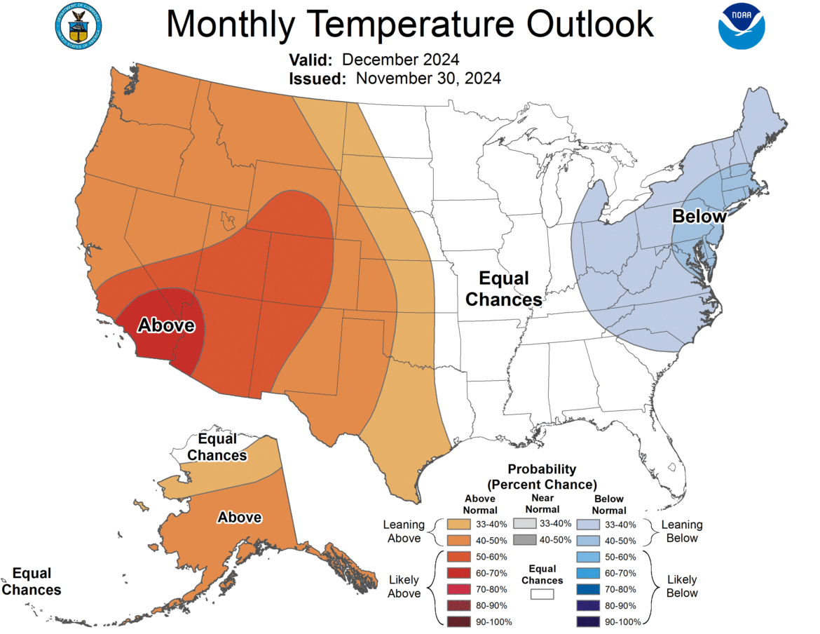
Temperatures are looking to run below normal and precipitation is looking to run above normal, especially downwind of the Great Lakes. That is amazing! We haven’t seen a December like this in several years. FINALLY! We are breaking the blowtorch warmth streak. With it continuing below normal for the next 6-14 days, expect more heavy lake effect snows to add up. And for the start of the season to be great!
WEAK LA NINA
It will definitely be a weak La Nina, if not a La Nada winter. Period. End of story. The weak La Nina conditions have favored the heavy lake effect snows and below normal temperatures. The lakes are still well into the 40s and will take time to cool off into the 30s. December should be a big month for lake effect. The rest of the winter? It should be normal at least. With the heavy lake effect we have had already, above normal snowfall is definitely more of a possibility.
FINAL WINTER WEATHER FORECAST FOR ROME, NY (Your area will vary)
Below normal snowfall (below 70″) – 20%
Normal snowfall (70″-117″) – 40%
Above normal snowfall (117″+) – 40%
This is my final winter weather forecast. Let it ride!
Zack and Rich Lupia
Upstate Snow
December 2, 2024
Please thank our advertisers on Upstate Snow for 2024-25
Banner Sponsorship
Enjem’s Flooring America
Ohio Ridge Riders
ilsnow.com
Southern Tug Hill Sno-Riders
Saratoga Snowmobile Association
Business Sponsorship
Paton & Son Excavating and Landscaping


