The Morning Blog 02.13.22
Sunday, 13 February 2022
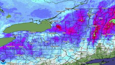
DA ROCK! That’s exactly what is left of the snowpack across Upstate NY. The pack has melted, quick froze and fused into one monolithic mass of ICE. Holy cow what a welcome back to NY! We arrive February 12-15 to conditions more reminiscent of March 12-15. We are so happy to be back and we
- Published in Weather
The Morning Blog 02.11.22
Friday, 11 February 2022
Warm and windy conditions today will mean melting and compaction. Bitter cold air coming in during the day tomorrow, lasting through Sunday, Monday and Tuesday, will return us, one more time, to decent conditions for riding and enjoying winter. Then after that, literally, the bottom falls out. I think I hear the Safari’s warming up
- Published in Weather
The Morning Blog 02.10.22
Thursday, 10 February 2022
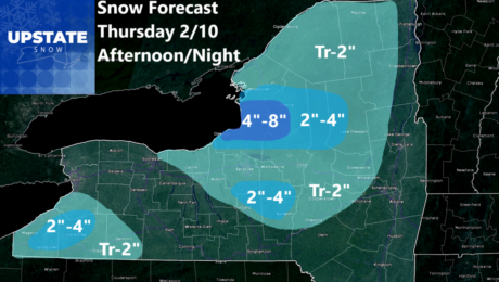
No changes made to the forecast for this afternoon and tonight. Light to occasionally moderate snows predicted, particularly downwind of Lake Ontario and Lake Erie. In particular, Tug Hill proper has the best chance of seeing in excess of 4″ of snow. This activity will clear out overnight tonight. Don’t blink tomorrow because the weather
- Published in Weather
The Morning Blog – 02.09.22
Wednesday, 09 February 2022
The snow overperformed yesterday, which I am sure given the milder temperatures, was a blessing to those that got it. We have to survive until sometime during the day on Saturday before the arctic cold front comes through and puts us back into the deep freeze for Super Bowl Sunday and Valentine’s Day. In the
- Published in Weather
The Morning Blog 02.08.22
Tuesday, 08 February 2022
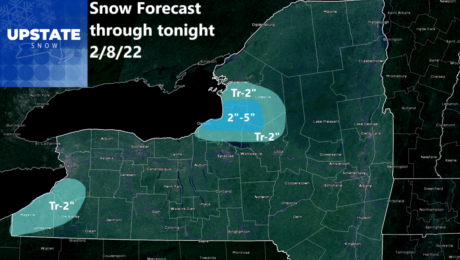
Lake Ontario and Lake Erie will sneeze later today and tonight and blow anywhere from a dusting to a few inches of snow inland. Areas with persistent flow, especially this afternoon and evening particularly Tug Hill proper, northern Oswego, northern Oneida and western Lewis Counties could see localized amounts of 2, 3, 4 inches, maybe
- Published in Weather
The Morning Blog 02.07.22
Monday, 07 February 2022
Before I start I wanted to say THANK YOU for all the love shown to Upstate Snow this past weekend, especially my video from Saturday Night. It was our plan to be there and to ride Tug Hill today and the Adirondacks tomorrow. Zack’s illness kept us from making the trip. He’s doing better and
- Published in Weather
The Morning Blog 02.03.22
Thursday, 03 February 2022
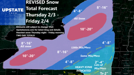
We are holding our forecast from yesterday. Short range models and current trends with rain changing to snow, show a sharpening line between heavy snow and heavy ice setting up along Interstate 88 from Binghamton to Oneonta to Albany. Get south of that line, a lot more ice and a lot less snow. Sorry Catskills
- Published in Weather
The Morning Blog 02.02.22
Tuesday, 01 February 2022
Revised forecast bringing heavier snows south and east over more of Upstate NY. Still a close call with mix/mess in the Capital Region, Catskills, and Hudson Valley. Areas to the north and west like WNY and NNY will be nearly all snow. A little mix/mess, especially at the start for the Finger Lakes, CNY and
- Published in Weather
The Morning Blog 02.01.22
Tuesday, 01 February 2022
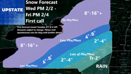
Most of the models continue to trend colder and farther south and east with the storm track and the area of mix/mess for our storm slated to hit us between Wednesday night and Friday afternoon. The NAM and GFS are among the more considerable models with snow, and a lot of it. If you look
- Published in Weather


