Enjoy your warm Thanksgiving and relatively quiet and mild weather for Black Friday and for Saturday. Sunday into Monday and Tuesday, the weather will turn very active.
What we know for sure: Next week will be stormy with lots of wind, especially Monday and Tuesday, with below normal temperatures, clouds and snow showers pretty much a lock for middle to end of next week. What we also know for sure is that a significant snow event will drill the central Great Lakes, Ohio Valley, central Appalachians and accumulating snows even into Kentucky and Tennessee. Yes, that’s not a misprint on the last two states. Confidence is high on that. Confidence is also high Upstate NY will be on the warm side of this big storm early next week, and largely miss that big snow event. Confidence is also high for strong winds across Upstate NY Monday 11/30 because of said storm with wind gusts of 40-60 MPH possible. Heads up on that. We know it will be cold enough after this storm on Tuesday 12/1 for the predominant precipitation type falling from the sky across Upstate NY to be snow instead of rain, and temps from Tuesday 12/1 to at least Sunday 12/6 will run below normal and generally below freezing a majority of the time.
What we don’t know yet: How much lake effect snow will be generated and where from Tuesday 12/1 to Sunday 12/6. Potential is there but the specific positioning of this storm track Monday 11/30 to Tuesday 12/1, and where the upper low stalls will have major implications on this. And what about the big potential Nor’easter that GFS was flashing for Friday 12/4? Well… the Euro, the more conservative wing of the model-ology court has some objections to that. This storm Monday 11/30 into Tuesday 12/1 is the main determining factor as to whether exciting weather (snow) happens in the days after that or not. The jury is still out on that.
So that’s the bottom line summary. The main course. If you want to geek out on the maps, models and details for dessert, keep reading…
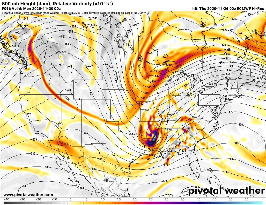
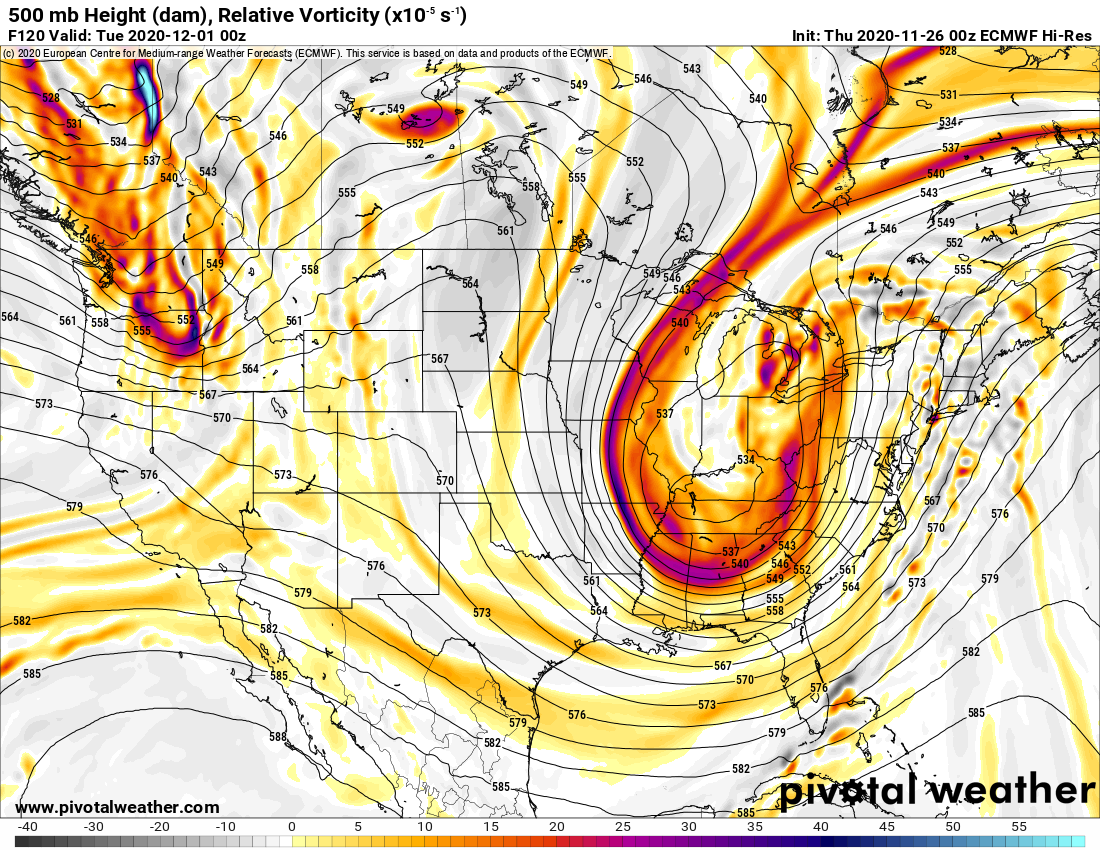
Here you see the upper air maps Sunday Night 11/29 showing the big circle and colors over the mid-south and the digging from Lake Superior, stretching SW back to Iowa that’s on its way to meet the storm over Arkansas near the Mississippi River. This is Meteorology, what’s about to happen, is what we call “phasing” or “phase in”, where two distinct storms in the jet stream, from two different regions (south and north in this case), combine or “phase” together into one large storm. You’ll see this happen on the next two maps, the upper air 24 hours later and the surface map showing the low pressure shooting into western NY around Buffalo, hence what generates the big winds across Upstate NY Monday 11/30, and with the storm track to the west, why Upstate is on the warm side and why snow gets way down into the Ohio Valley, KY, TN, WV and western VA on the cold side…
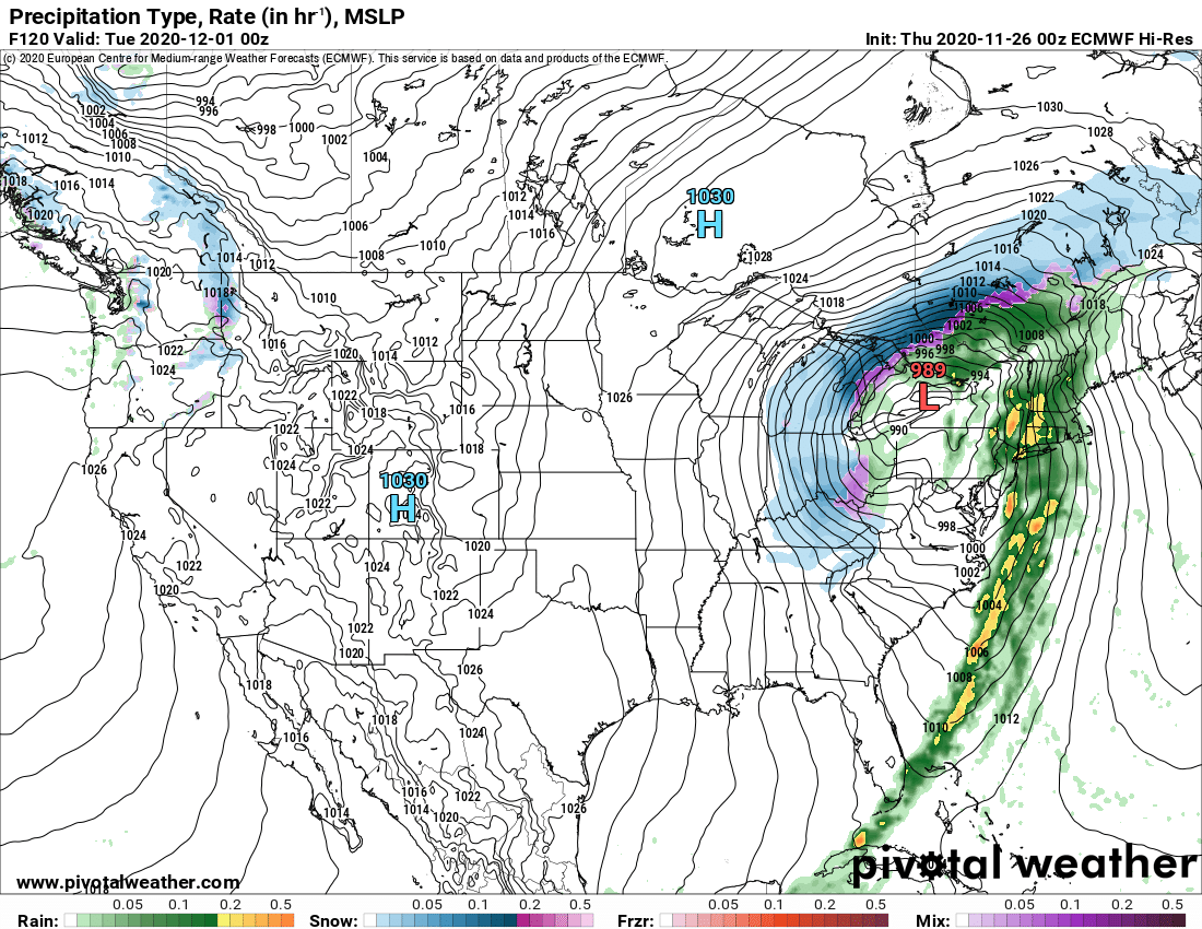
This storm stalls and weakens over the Great Lakes from Tuesday 12/1 into the rest of the week, through Friday 12/4. Depending on how fast it breaks down and where exactly it is positioned is KEY. The next storm for end of next week Friday 12/4 will be guided by this. If it breaks down more quickly and the trough position is to the west of Upstate NY, then it would open up the door for the GFS idea of a big Nor’easter to take shape as indicated below with lots of upslope mountain snow and lake effect behind it
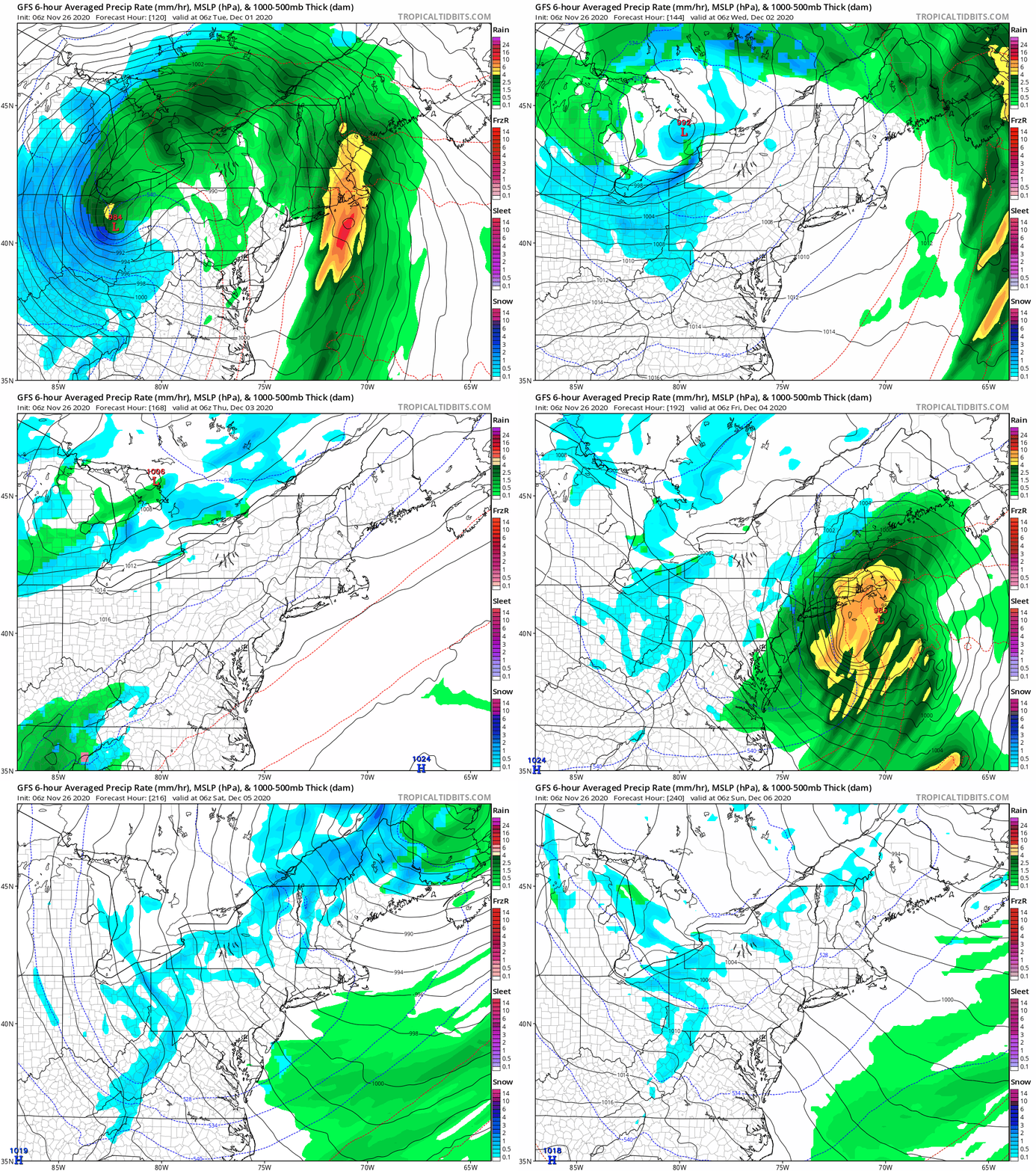
BUT just because the models show it doesn’t mean it can scientifically happen. IF the Euro idea of a stronger cut off low in the upper atmosphere, parked near or over Upstate NY does indeed happen, the approaching storm from the south will be pushed much farther off the coast than the GFS is showing. It’s also showing a much slower progression of that next storm, still holding it back by a day or so.
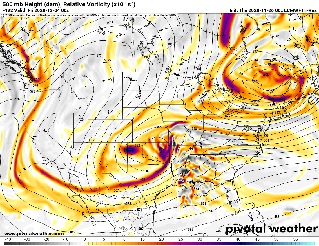
OK but Rich! Why can’t those two storms at the end of the week “phase in” and become one gigantic storm??? Bonus points if you can figure out the answer. It’s laid out clearly in the upper air maps I just showed you above earlier in the blog. If you have one “closed low”, meaning the circles around it and a weaker trough “digging” into it, like a wave, it is much easier to “phase” the two, take the energy from the trough, and make that existing closed low much more powerful. When you have two “closed lows”, two separate distinct areas of low pressure in the upper atmosphere, it is much more difficult to slam the two together and phase them into one huge storm. You can bully a weaker storm “trough” much more easily than you can a bigger storm already well developed.
Hope this was a welcome read and distraction for you today. Happy Thanksgiving. We hope you, your family, friends and loved ones stay safe and healthy in the days and weeks ahead.
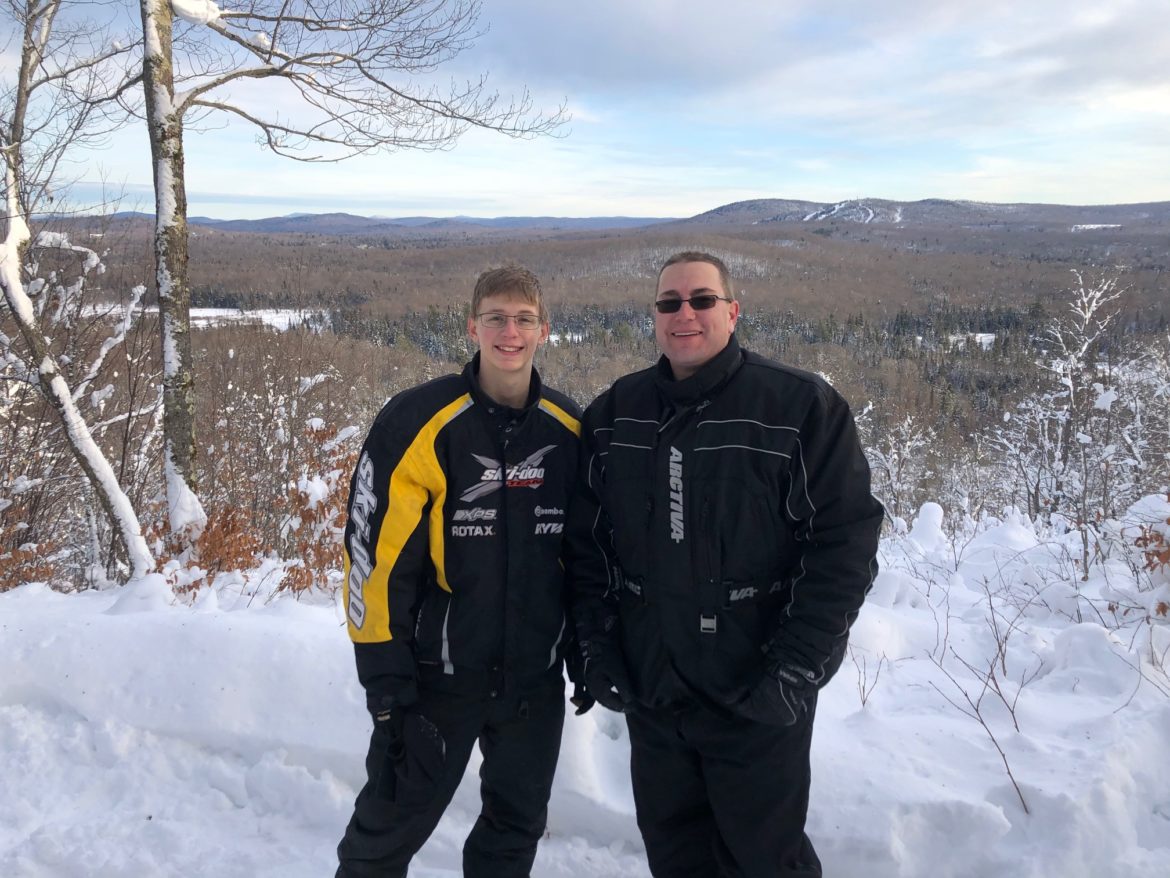
And finally, THANK YOU. I am so thankful not just for my son Zack, the best riding partner a father could ever ask for, but for my family, my friends, loved ones… AND ALL OF YOU! Because thousands upon thousands read these weather blogs, tens of thousands see the content on social media, snowmobile clubs and businesses generously give their support to this project started in 2012… this eight year ride continues to ride on. It’s a blessing to be able to inform and help all whom read this: snowmobilers, winter weather enthusiasts, others wanting good solid weather information.
I am thankful for you all.
Rich


