Yes good news heading into next week in the short term but indications are now very strong that this pattern change next week is not going to hold. It’s enough to make your stomach churn as you will see in the details. Mine has been literally the last 36 hours which had me wiped out and just starting to recover. And this report, well, may literally be that to you. This is particularly true for those waiting to ride near and south of the Thruway. Here i’m seeing less and less hope for the next few weeks 🙁
What is the good news if any?
We are still going to see rain change to snow Saturday during the day and especially Saturday night into Sunday. Modest accumulation of snow, mainly N of the Thruway, as you see in the snowmap.
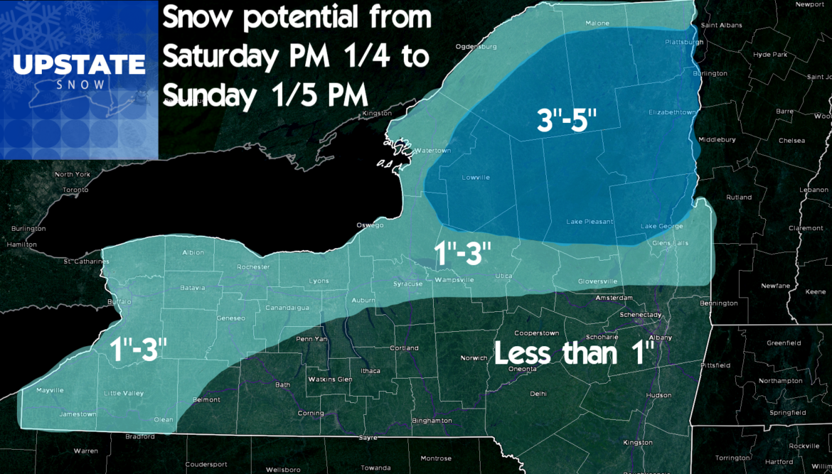
We still have a clipper coming Monday with colder temps, a few more inches of snow and some minor lake effect after that.
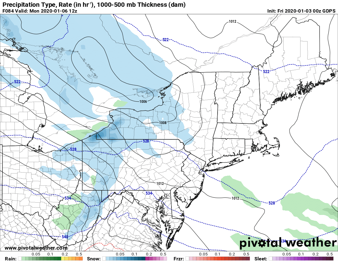
We still have strong indications of a general snow event later Tuesday into Wednesday from a low cutting south of us from the Ohio Valley through Pennsylvania off the Long Island coast. This could bring a moderate snowfall across most of Upstate (probably not double digit totals from what i’m seeing but shovelable/plowable accumulations if the models are correct).
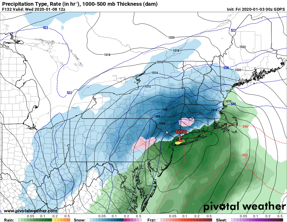
But after that all bets are off. I explained in previous blogs and live weather hits on FB live how the pattern change would not be perfect as things like the Newfoundland Low, Greenland Block, Western Ridge and Polar Vortex dropping south into Canada, are not lined up in the best spots. Yes better than the last 10 days of December, but not favorable for major cold and snow. A few days ago it appeared the pattern change would be full bore with major cold and potentially significant lake effect snows in the January 7-10 range. That’s simply not materializing. Look at Saturday morning 1/11 and it’s enough to give you the stomach bug…. UGH…
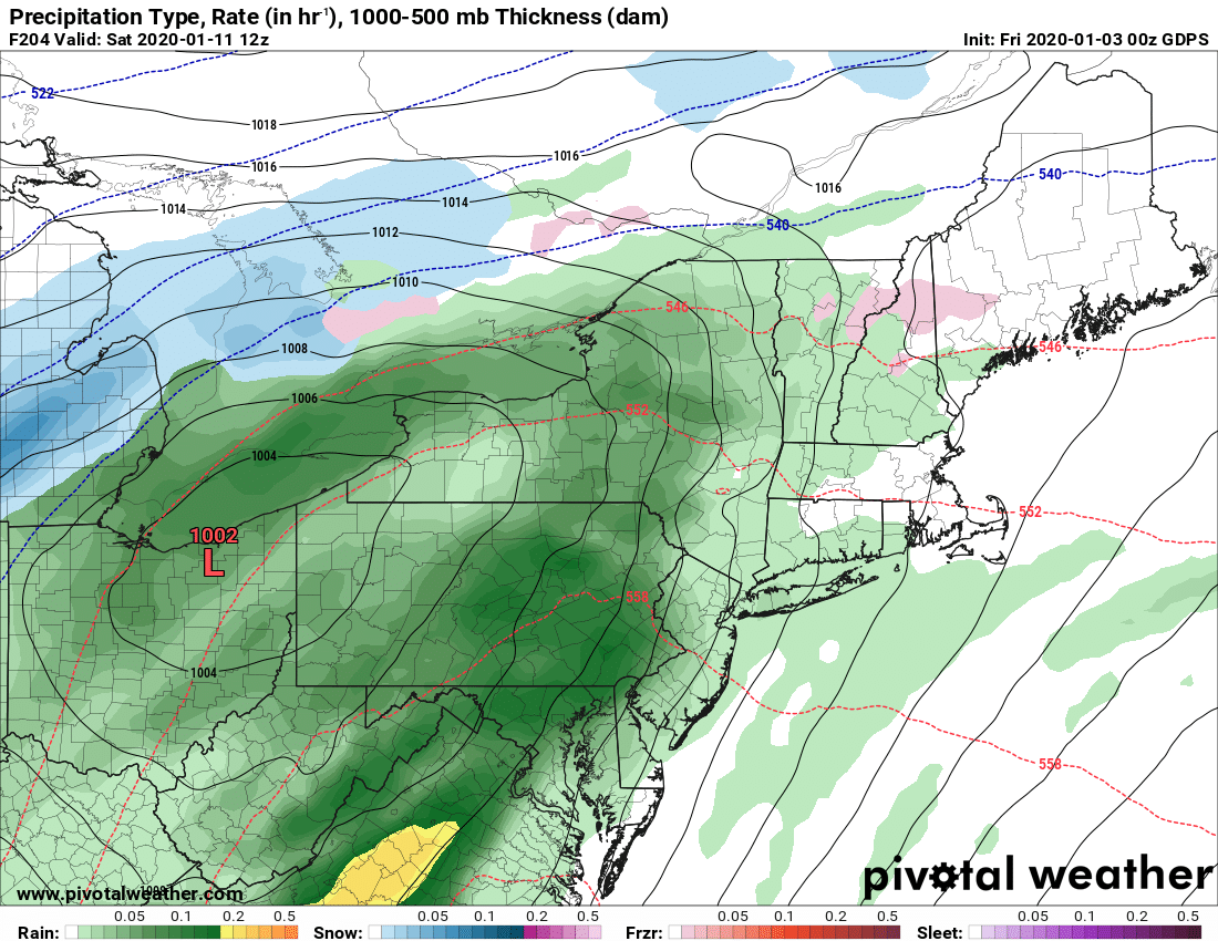
So why the changes?
When the weather patterns are not set up right for cold and snow across Upstate, when you have big time cold in Canada and big time warmth across the south and southeastern US (anyone notice 50s, 60s and even 70s more days than not south of the Mason/Dixon line??), the weather pattern is highly volatile. You have such a sharp change in temperatures over a smaller area, it can and does create a very fast and active jet stream. Any disturbances that hit this zone, things go nuts. That’s why Christmas travel and New Years travel in the Central and Western US was such a mess. Just like Thanksgiving was here in the east. The unfortunate reality is that the longer range models took some of these storms and altered the patterns in the 1-2 week range in a way it looked like the storm tracks would be a little farther south, cold would be just a little better established over Upstate with the coldest air just to our north in Canada, and the warmth would be pushed farther south. As things have actually happened, different that the projections a week ago were, the models are catching up with the fact this highly volatile weather pattern will continue now well into January.
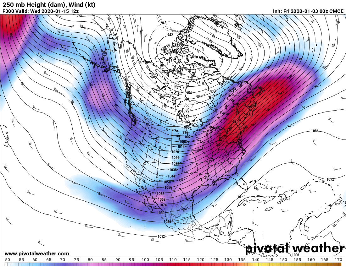
This first week of January will still be decent for cold and snow as well advertised for most of Upstate, especially along and N of the Thruway. Going into the weekend of the 11th-12th, it’s not looking good with a warm shot and rain now looking likely across Upstate. Second full week of January (13th-18th) looking very up and down with swings from 40s to 20s, rain to snow, and no long term sustained cold air settling in more than a few days. As you can see from the ensemble mean jet stream… things are not in a good place for sustained cold and snow for us. Polar vortex too far N, NO BLOCKING AT ALL, No Newfoundland low and a trough over the central US along with an almost Bermuda high off the SE coast is NOT GOOD. As you see jet stream winds going crazy over us. This means stormy weather is likely with wide swings in temperature from warm to cold and from rain to snow to rain in much shorter periods of time.
So what does this mean for my chances of riding across the state in the next few weeks?
In general, it does not mean all is lost for Upstate in this pattern next week and especially beyond. It means it’s now going to take longer to get where we want to be and a shorter season of “prime” conditions looking ahead. This is NOT 2011-12. This is NOT 2015-16. But at the moment, we have to play with the hand being dealt to us.
Tug Hill and Adirondacks – Since they are the coldest and snowiest places in the state, and because they’ll be just far enough north, most of the riding and pressure on the trails will continue to be here. Since these areas have whatever base was left, they will be in the best position to recover from the warm spells. If i’m planning rides through MLK weekend and beyond I’d be ready to go on a moment’s notice if you can to catch the best conditions, be flexible with where you go and set expectations reasonably conditions may be poor to fair at times with water hazards more likely than usual for January.
Approaches to Tug Hill and Adirondacks along & North of the Thruway and Western NY (south of Buffalo in the Lake Erie snowbelts): Catch as catch can. You may get chances to go if the snow is deep enough but clubs will not have sufficient cold or base the next few weeks to set things up the way they want. Since almost all the clubs in these areas are closed due to low/no snow now, please be patient and wait for clubs to say whether it’s good to go when snow does come. Don’t count on snow staying too long, expect early season and changeable conditions if these clubs are able to open for a bit to go out. And lend them a hand where you can with trail issues.
Areas South of the Thruway and near/east of I-81: Not looking good. This area I have the lowest confidence they will get enough snow and enough of a window to get out there and keep it based on the weather pattern. If you do get the chance and the clubs say it’s ok, take what you can when you can and set expectations reasonably.
ABOVE ALL ELSE… RIDE SAFE, RIDE RIGHT AND KEEP THE SPEEDS DOWN. With less than optimal conditions across the state where there is riding, more riding pressure on those trails, it’s critical to cut the speeds down, be extra vigilant to other riders and hazards. Please enjoy your rides with your friends and family, when you can, safely, to ride another day.
As for the weather, I’ll do my best to highlight the positives and be real about the negatives. With the highly changeable weather pattern currently, keeping up with the blogs, videos, trail talk podcast and the Guide to your ride podcast with STH’s Chris Rinck is important. If there are good opportunities and good snow that pop up, we’ll let you know so you can take advantage of it. That’s ultimately why we are here.
Thanks for your patience with the longer than normal blog, please support the clubs and businesses that support us, and best wishes for a great 2020 ahead.
Rich


