The models are drunk. This is about as stupid as I’ve seen all three major models I look at (American GFS, Euro, Canadian) be at the 5-10 day range. They all have their different scenarios. This is making any sensible projections for medium range planning in the 5-10 day range an exercise in madness. So why is that? Two things:
1) It’s because of how powerful and strong the jet streams are at this time, especially the southern branch of the jet stream. All models have a hard time with this, especially the American GFS. When the jet streams are phased (together) and/or the northern stream dominates, it tends to be more stable.
2) It’s a tribute to how far we’ve come in weather forecasting. For all the bashing us Meteorologists get, if you stop and think back 15-20 years, most only had a 5 day forecast and you were lucky if day 5 was 50/50. This was especially true when I worked in TV back in the late 90s and early 2000s. We now have 7 days, some stations up to 10, and we are better than a coin flip at day 7.
It was a miracle of science that 5 days, 120 hours out, in March 1993 we saw the Blizzard of 1993 coming and had the confidence to put the forecast out. Now think back to this past Thanksgiving weekend storm. We started talking about that on the 19th and had a solid idea of the travel issues by the 25th/26th prior to big storm on the 30th. While intensity and final snow totals at a point were a challenge (and always will be), we’ve got a clue it was going to storm big and have big travel impact. What was unheard of 25+ years ago is now commonplace… several days reliable warning to bigger storms.
At the end of the day weather is going to do what it’s going to do. In a spiritual sense as I personally look at it, God is God and I am not. We do our best to figure things out.
OK, so off the rabbit trail and back to the here and now… Based on my analysis for the three main models, what makes sense and what doesn’t?
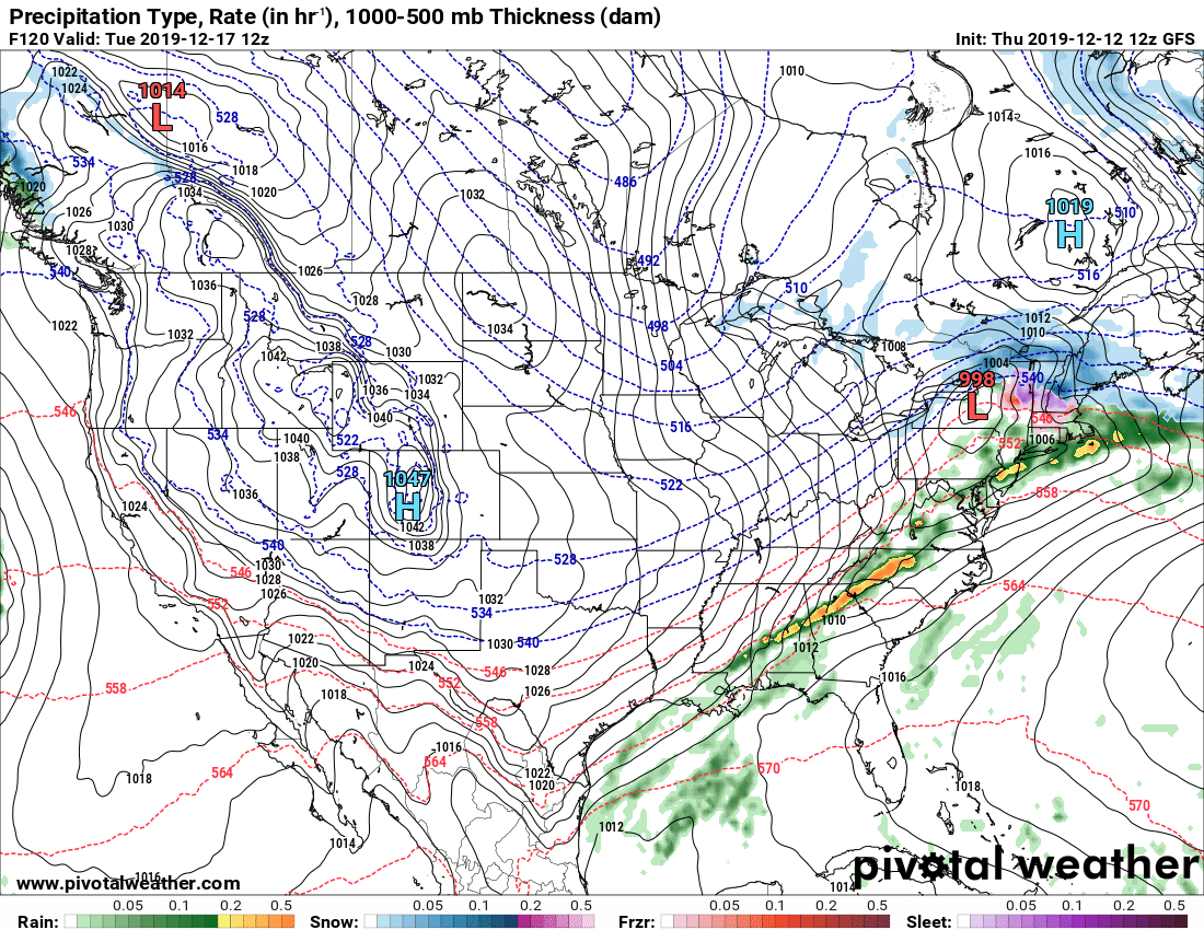
GFS – Ok out to 3-4 days then loses its mind. Because this model has a strong cold bias and gives to much credit to the northern branch of the jet stream, it causes solutions like this here. When you have a storm off Newfoundland, it usually produces a high to the W of that over Quebec and northern New England. Check. Because of the laws of motion, you cannot have a storm CRASH into a high and go up the St Lawrence Valley, to the NW of Upstate in this pattern. As you see from the GFS below, that’s EXACTLY what it does. This GFS idea of the Monday 12/16 to Tuesday 12/17 event going up the St Lawrence into the High over Quebec at the end of the same valley is IMPOSSIBLE. So based on the GFS bias, this model is OUT.
That leaves us with the Euro and Canadian to consider. They both are strong models and they have solid more reasonable ideas. Based on the fact the Euro has been the most consistent and reasonable with the forecast, I will lean heavy on the Euro.
So with that in mind, after all that setup… the forecast from now through the next bunch of days…
The storm approaching tonight into Saturday will have it’s advertised warmer air and rain overspreading Upstate, no change to that we’ve expected all week. I did note in my blog on Wednesday the fact the track now goes most S and E of Upstate, to over us, introduces a chance for a blessing on the back side of the storm. Some TV stations, especially in WNY, have pounced on this promising 6″ of heavy wet snow on the back side of this storm Saturday night into Sunday morning. Is this possible? Yes. Would I forecast it on TV with certainty as some have? No. Exact storm track and temp profiles plus where the precip goes in relation to it will make all the difference.
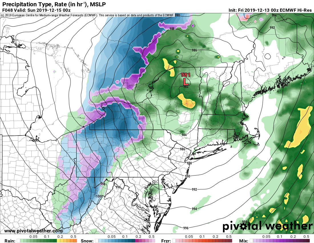
So the track on Euro hits the Adirondacks. This will not happen. It will go up the Hudson Valley. Yes there will be rain going to wet snow especially West of I-81. I think 2-4 of wet snow west of 81 with a dusting to 2″ from 81 east is a reasonable first call. I will do a snowmap on the next update video tonight with Zack.
This storm will go to Newfoundland by Monday and set us up for the next storm coming up the Ohio Valley. This could be a decent one. While not a perfect setup we will have the track be just far enough S to bring a mainly snow event late Monday into Tuesday along and N of the Thruway, snow to mix back to snow for areas S of the Thruway.

So the bottom line here is that, we have some hope to get some snow back for riding next week up north, and at least a small chance for some areas south as the rest of the state opens for snowmobiling, conditions permitting, December 17 Tuesday. There is hope. I’ll elaborate a little more in the video this evening and of course track through the weekend.
So as we always say, check with the clubs before you go or trailer up anywhere. Until these storms hit, there will not be any significant and/or safe and/or long distance riding available.
Be patient with the clubs and with mother nature. We all want to get out. We’ll get our chances, even if we have to run quick and take them in between storms.
See you soon,
Rich


