Before the snow gets here, heavy rains and warm temps will take a bite out of our snowpack Christmas Eve. The models are not in 100% agreement but closer than they were and I’m comfortable enough to take a shot at some details.
Please note: This forecast is very much subject to change. Timing of the rain and the cold changing it to snow, wrap around moisture, the evolution of the Lake Effect Snow, shifting of the bands, all of it could dramatically impact forecast amounts at a specific place. Even the NWS Buffalo whom issued the watch nearly two days ago is staying with the general “over a foot” for accumulations and saying “details need to be ironed out”. The only difference between us at this point is I am throwing the deep ball towards the end zone… but it’s only second down. If this forecast doesn’t connect, I have Christmas Eve and Christmas Morning to revise. This is most likely as of now.
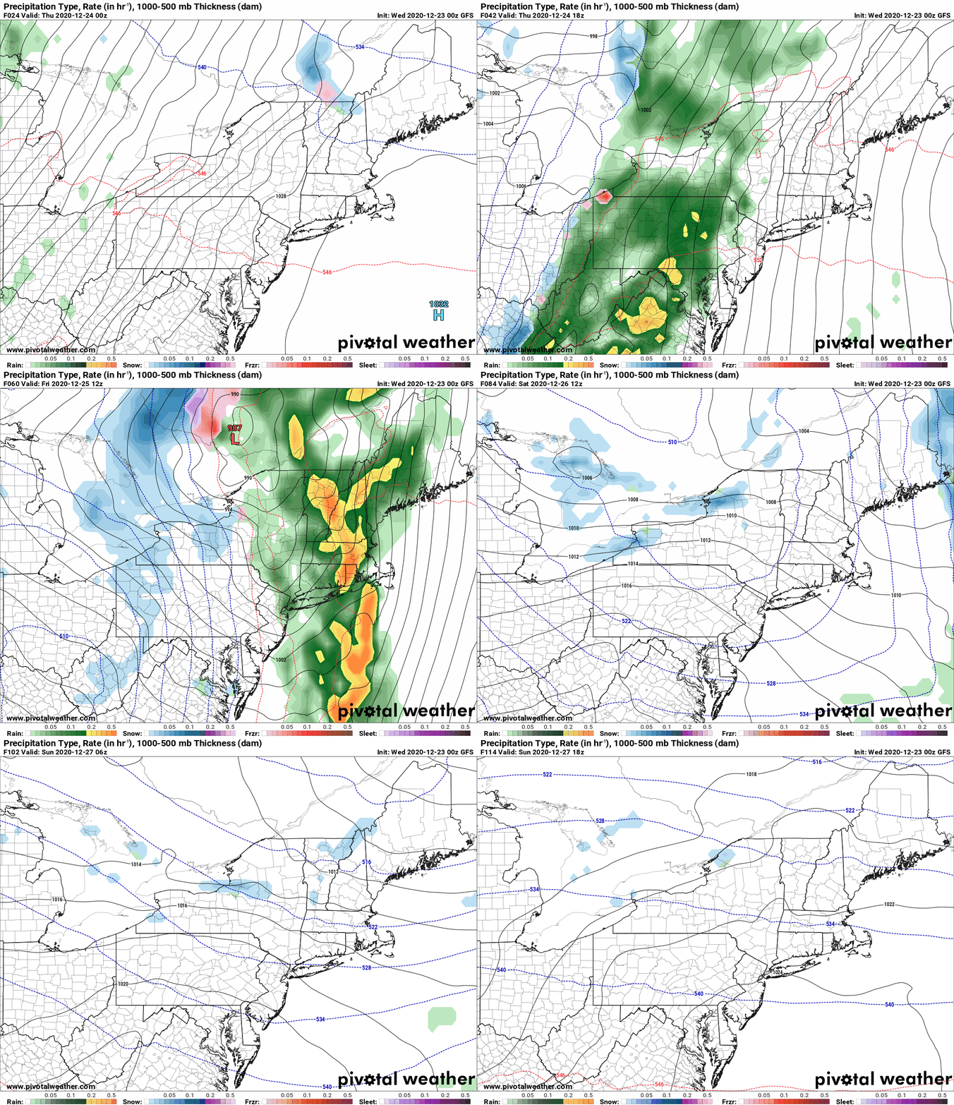
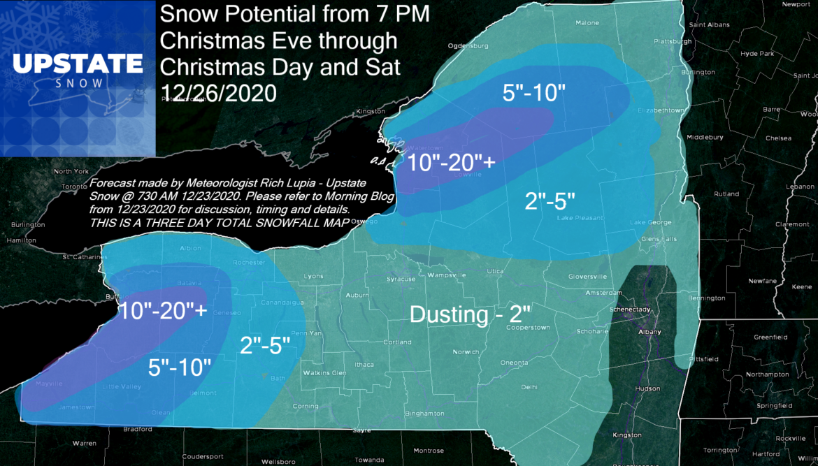
The model of choice this time around is the GFS. Say what? But Rich you hate the GFS. Well, most of the time I do. Sometimes it has good trends and good ideas. In this case I like it better than the NAM, RGEM and Euro (At the moment) because it’s doing these two things the best: 1) The quick drop in temps changing rain to snow. In all sharp cold fronts, it happens at a point anywhere from minutes to a few hours. The temp clash will be sharp. Once the cold front crosses, expect a 20-30 degree drop in just a few hours. Rain goes to snow. Flash freeze likely on the roads. Here is the GFS idea from tonight through Sunday… In slow motion… Discussion below to follow plus a repost of the snow map in the headline:

Today and tonight: Quiet, Mild but not super warm or windy. Yet.
Christmas Eve: During the day conditions go down hill gradually. Temps rise and winds pick up during the morning with scattered rain showers. Rain becomes more steady, temps in the 40s to low 50s from afternoon into the evening.
Christmas Eve Night: Rain heavy at times. Gusty south winds. Temps 45-55F. This is when the snowpack will seriously compact and deteriorate, especially where there isn’t much. Strong low pressure tracks west of 81 and over Lake Ontario overnight. AS SOON AS THE LOW PASSES, winds shift quick and hard to the west, and the cold air comes in WITH AUTHORITY. From Buffalo, westbound, it happens between 7 PM and Midnight. From Buffalo to Rochester, between Midnight and 4 AM. In Central NY from the Syracuse area to Utica/Rome, Binghamton and Watertown, between 4-8 AM. It takes until Midday to clear the state.
Christmas Day: In the morning steady and lake enhanced snows over WNY taper off, Snows get going for a few hours across CNY, Tug Hill, the Southern Tier and the Adirondacks. Temps fall well below freezing quickly. Untreated surfaces ice hard quickly and travel especially on secondary roads becomes very slick. In the afternoon snow showers linger across the state, but there will be a period the lake effect snow does not get rip roaring. That changes after the sun sets Christmas night.
Friday Night into Saturday Morning: This is when the lake snow bands will be their heaviest. I’m expecting (subject to change a 250 to 260 wind direction). This means city of Buffalo and the Southtowns get hammered. Even the Tonowandas to Lockport and Medina could get in on this. The band should stretch from Chautauqua County up through those Buffalo areas mentioned, Wyoming and Genesee Counties… Batavia area should take a good hit, and if should carry to the suburbs of Rochester. Most of the snow potential I have in this three day total will fall from late Friday PM through Saturday AM in these areas. The same will go off Lake Ontario. I expect at this time that line to bisect Tug Hill. North side of the line gets it good, south side not as much. In terms of placement, if you remember the epic lake effect “blizzard warning” from late February 2020, those places that got nailed, expect the same areas to get the worst. Jefferson County. Northern half of Lewis. St Lawrence County. Several inches will likely carry up to the Tri Lakes area, potentially as far as the high peaks. This should hit mostly NORTH of Big Moose, Old Forge and the MRP. Think Stillwater to Norridgewock, Sabbatis, Star Lake, Harrisville, Cranberry Lake to Tupper Lake.
During the day Saturday: A trough will swing by in the afternoon and may give a quick burst of snow over a lot of Upstate NY, just a dusting to an inch for most, and the lake bands begin their shift south Saturday PM into Sunday AM. Off Lake Erie, Chautauqua, Cattaraugus, Allegeny, will get the most as bands come south on a 270 to 280 wind flow. Off Lake Ontario, it gets over Tug Hill proper then hits the southern half of the hill and makes a run towards the Mohawk Valley and the Thruway but should stay mainly north. It’s the southern half of Tug Hill, northern Oneida and Herkimer Counties, Hamilton County and points east, most of the snow on the snow map, outside the few inches after FROPA Christmas morning, falls Saturday PM 12/26 into Sunday morning 12/27.

During the day Sunday, lake snow tapers off. Next clipper Monday/Tuesday. Models want to take this N again and cut down snow. I hope this new trend is only an anomaly and not the breakdown of the good pattern I was eyeing. We shall see in the coming days.
This information, again, not set in stone, but a good guide to go by for now. I do expect to make another snow map for Christmas Eve and yes, I will give the gift of a blog on Christmas Day… not sure when… like you I will be with my family for our annual traditions and giving thanks to God for his son Jesus on his birthday.
Merry Christmas,
Rich


