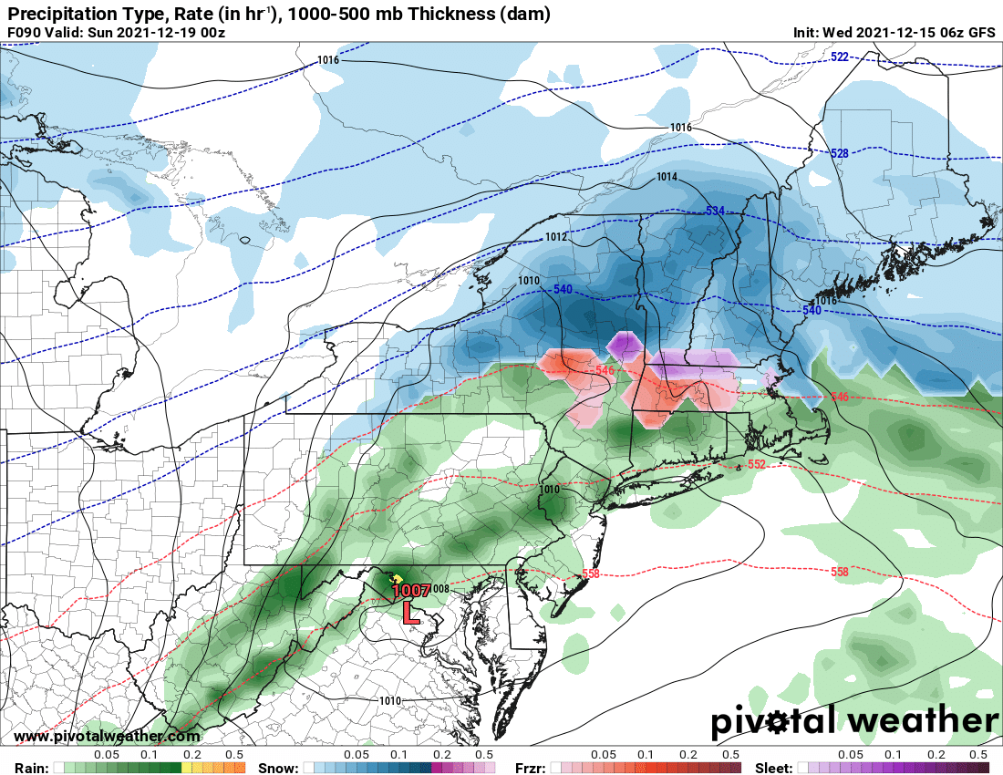
Odds are increasing quickly for a snow event, especially along and north of the Thruway developing Saturday and tapering off on Sunday with a little additional lake effect. It won’t be what we need to ride. But it is snow. And it is a start. And with this being the 5th model run in a row showing this scenario, the GFS and Euro are now almost identical, we are getting down to the details here for snow’s return to Upstate NY.
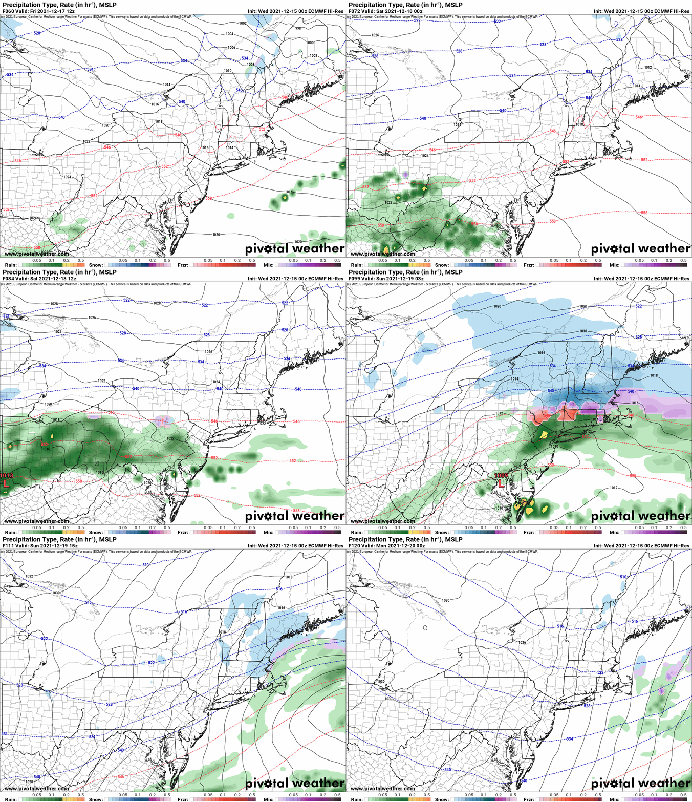
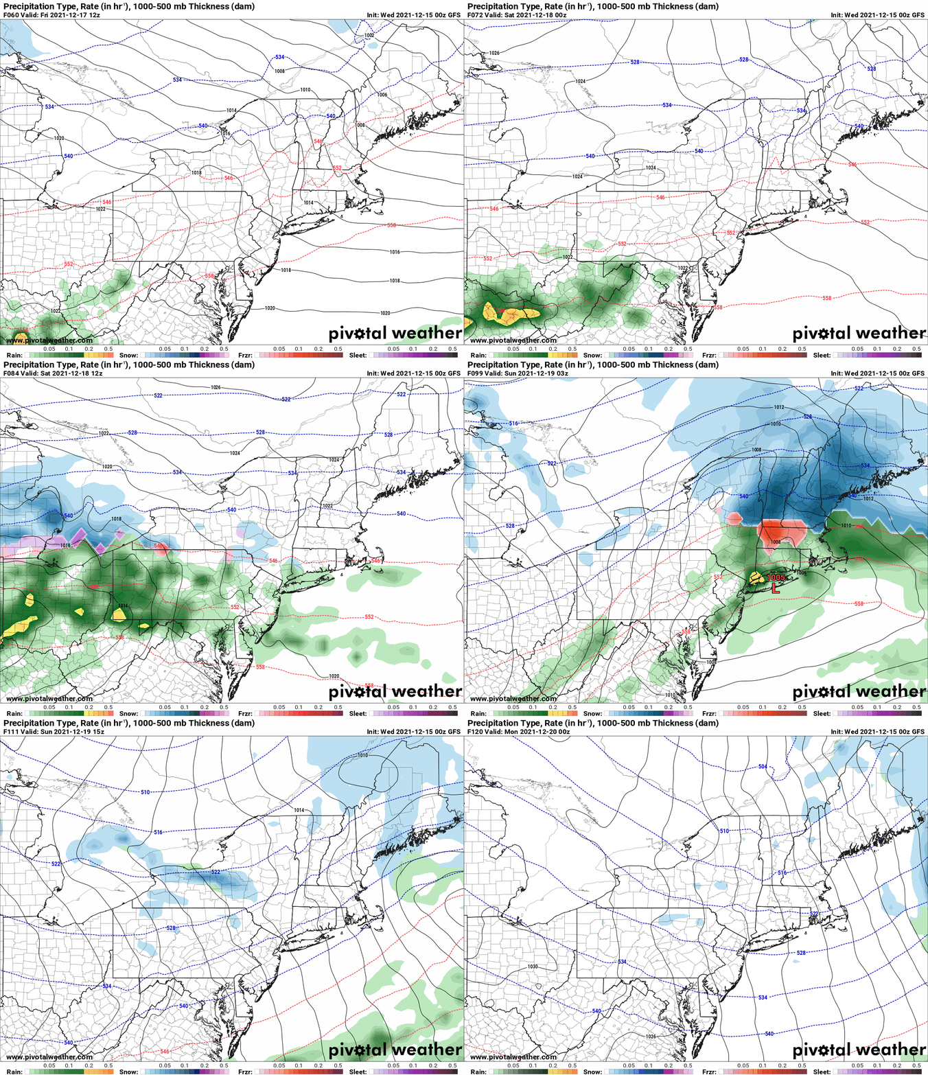
We all know about the record warmth rain and 60s coming tomorrow. Enough of that. Cold front moves through and Friday is a much closer to normal day, but still tacking above by a few degrees. Most likely 30s with some 40s leftover in the lower elevations, especially south of the Thruway. As I mentioned yesterday the front that goes through Thursday, stalls to the south of Upstate NY across the Virginia’s on Friday, then attempts to lift back north as a warm front on Saturday with a new developing low pressure system riding along it. It’s track has been insistent by the Euro for the 5th run in a row now, and over the last 3 runs, the GFS, now getting out of its longer range biases, gets within 120 hours, and especially 96 hours and goes, whomp there it is! Both models are choosing southern PA and Maryland as the track.
This is a “cutter” track for Upstate NY. Cutters are generally the easiest snowfalls to predict because there is usually no changeover, it’s a set amount of time, and a set amount of precip, just do the ratios and you are done. Not in the winter of 2021-22. It’s in the 70s on the south side of the front. And the north side is not as cold as it should be plus, hardly any snow cover to help hold the cold air. Keep it from modifying too fast. This is going to set up the mix areas, the rain snow line much farther north than the actual low track. That mix/mess will make it into the Southern Tier and the Catskills. Some may even try getting into CNY and the Thruway corridor. North of the Thruway looks safe at this time. Here are the Euro and GFS runs of this system running through the storm period.
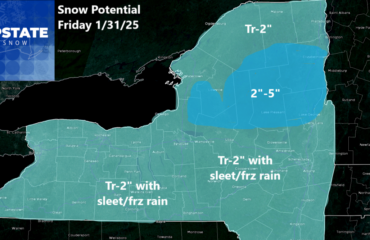
Saturday starts off closer to seasonably cold with 20s and 30s widespread. Increasing clouds and precipitation developing during the day, especially in the afternoon. High building to the north is the cold air supply, record warmth trying to come back from the south overrunning the colder air trying to come in. This will be a general, synoptic snowfall event Saturday afternoon, Saturday night, tapering off Sunday morning. Based off of the models only (not and official forecast), these are the snowfall amounts being put out by the Euro and GFS.
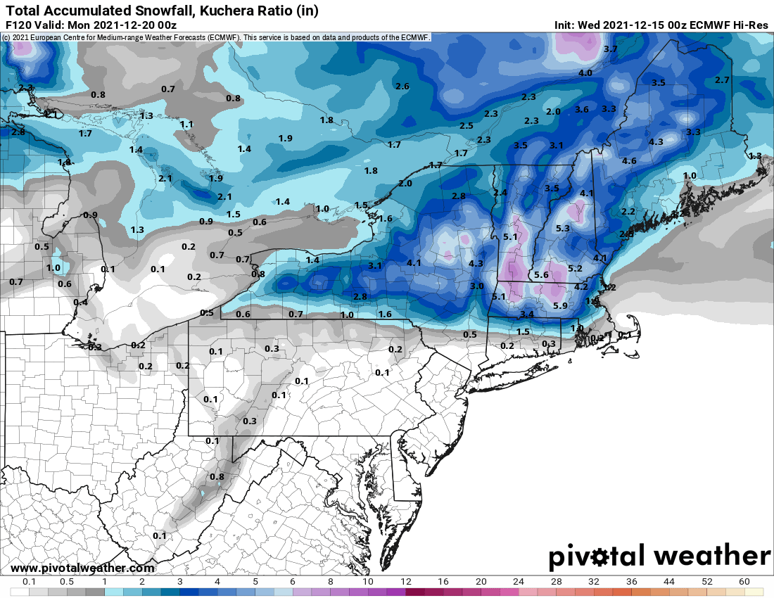
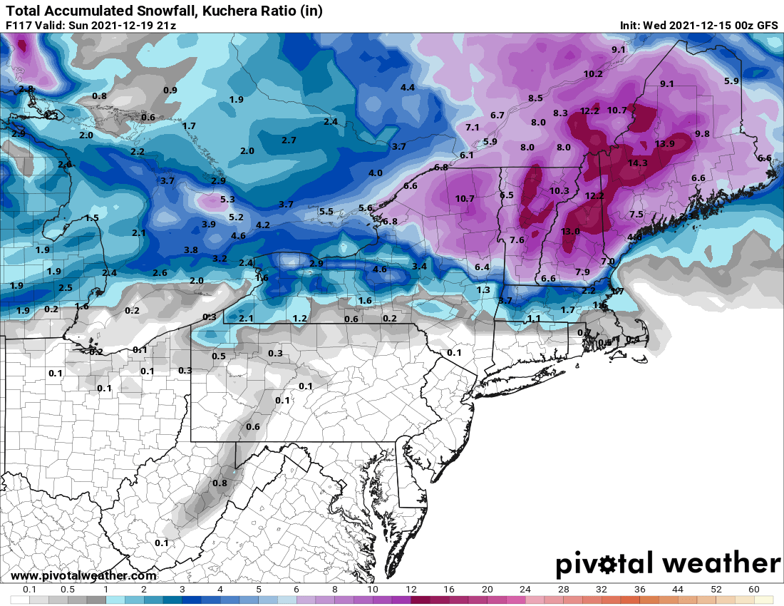
So what will we do? Tomorrow we put out a first call snowfall map. Since most of the event will be in our 72-84 hour window by that time, we make our first bet. Any revisions come Friday and/or Saturday based on mesoscale modeling and changes to where that rain/snow line or transition zone set up. If that zone moves north, it’s mainly just a Tug Hill/Adirondack storm. The more it moves south, the more of Upstate NY gets painted WHITE.
So what about after Sunday Rich? Well I’m glad you asked. It stays seasonably cold. No widespread single digit temperatures yet. It’s a good start. High pressure ensures Monday is a sunny and dry day. Models still going crazy with yet another storm developing along that zone, but the next one comes much farther south of Upstate NY. Much more back and forth on that one. Towards the middle to end of next week, Christmas Eve and Christmas Day, it is starting to trend COLDER. Enough to where I can start to say temps at or below normal from Christmas Eve/Day and beyond. Not enough to go hogwild with cold, snow and lake effect yet. But enough to where I can say with at least a little confidence it won’t be 68 on Christmas Eve like it was in 2015. The teleconnections we look at here, PNA, NAO and AO are starting to become better positioned around and after Christmas. NAO and AO start diving into the negative. That is GOOD for winter weather lovers in Upstate NY. The PNA… ehh… not so much. So the teleconnections we want, the perfect winter weather pattern we want will not be there. But by Christmas Eve/Day, it will look a lot more like it should for this time of year. And that’s a start from where we are right now.
Special thanks to our newest members and sponsors of Upstate Snow! Just want to take a moment to say THANK YOU for your support and encouragement, even when we don’t have a whole lot of snow outside. If you enjoy our weather reports, podcasts, videos, and features, here is how you can help out! For just $60, sponsors receive a hyperlink to your business or social media page on every morning blog and podcast post on upstatesnow.com for the season (until 8/31/22). For just $10, members get name recognition, or if you wish not to use your name, recognition to your favorite snowmobile club or where you live.
Click below to get started
paypal.me/lupiallc
www.venmo.com/u/Richard-Lupia
THANK YOU to our faithful sponsors and members!
SPONSORS
Southern Tug Hill SnoRiders
Saratoga Snowmobile Association
Ohio Ridge Riders
ILSNOW.com
Enjem’s Flooring America
Water’s Edge Inn – Old Forge
Adirondacks Speculator Chamber of Commerce
White Lake Inn
Toads LLC Fisher and Snow Dog Plows, Cairo, NY
John Schoff Memorial Vintage Ride – January 15, 2022
Lincoln Mountain Gansevoort Snowmobile Club
MEMBERS
Chris Rinck
Charles Klesse
Chaz Albertson
Dave Gleasman
John Bates
Darrin Harr
Mark Enjem
Matthew Pistner
Eric Vilovchik
Brian & Paula Bedell
Robert G. Gartley
Chris Higgins
Nathan DeMarco
Frank Presky
Chris Schoff
Richard Keller
Mark Spano
Paul Marconi
Michael Schrader
Chris Skipper
Frank Sansone
Mercy Board LLC
John Scalora

