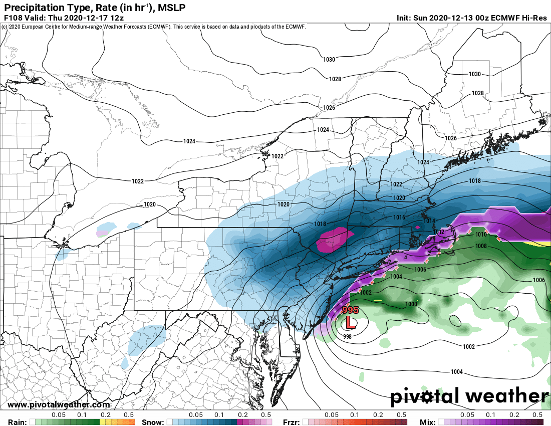
It’s going to be a close call on tomorrow/Tuesday and Wednesday/Thursday storm systems. The models are agreeing much more on the overall pattern at the jet stream level but still are having a spirited discussion on the details of the surface low pressure and associated snowfall across Upstate NY.
If you are a fan of ours in the NYC area, Long Island, southern New England, NJ, PA and farther south to Virginia, no doubt your local TV Mets have been screaming red alert about both systems with significant impacts in your local area in the days to come.
It’s a general rule, but not every time, that when these afore mentioned areas are under alert (Mid Atlantic States and the Megalopolis), these storms generally do not hit interior Northeast and Upstate NY, especially CNY, WNY, and the Tug Hill, major focuses for our coverage on this site because these are the more popular snowmobile areas. Again, general rule, there are exceptions.
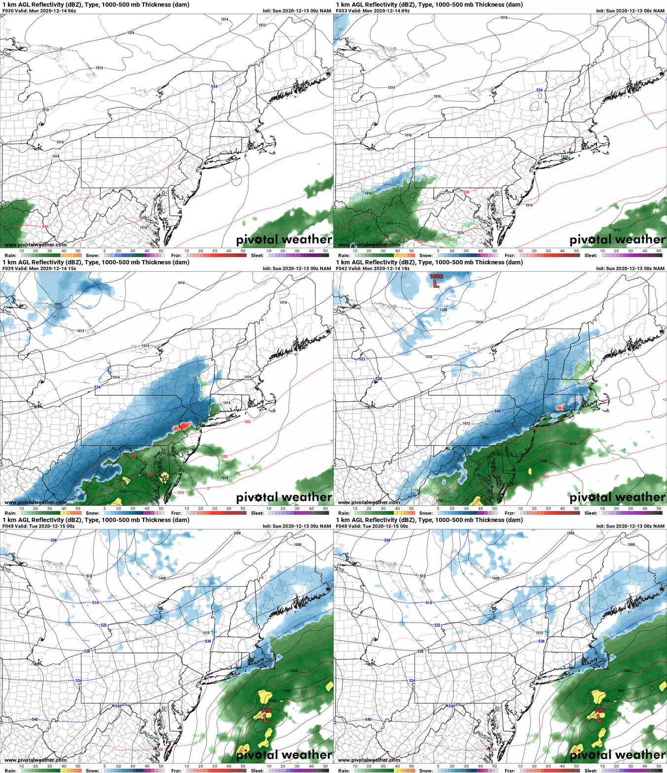
Lets deal with storm #1 tomorrow and remind you of the significance of this setting up Wednesday/Thursday for the bigger storm. The NAM below shows PA, downstate NY and southern New England getting the brunt of it. This first storm is becoming stronger and more energetic with heavier precip. I was even tempted to do a snowmap for tomorrow afternoon/evening but because most of it would be SE of I-88 and south of Albany, and with the Wed/Thu event looming I didn’t want to cause confusion. Just know if you are from the Catskills and Mid-Hudson Valley, southbound, expect accumulating snows and slick travel conditions for PM commute Monday PM. This will largely avoid Upstate NY outside of snow showers with little to no accumulations for the Binghamton area to the Capital Region.
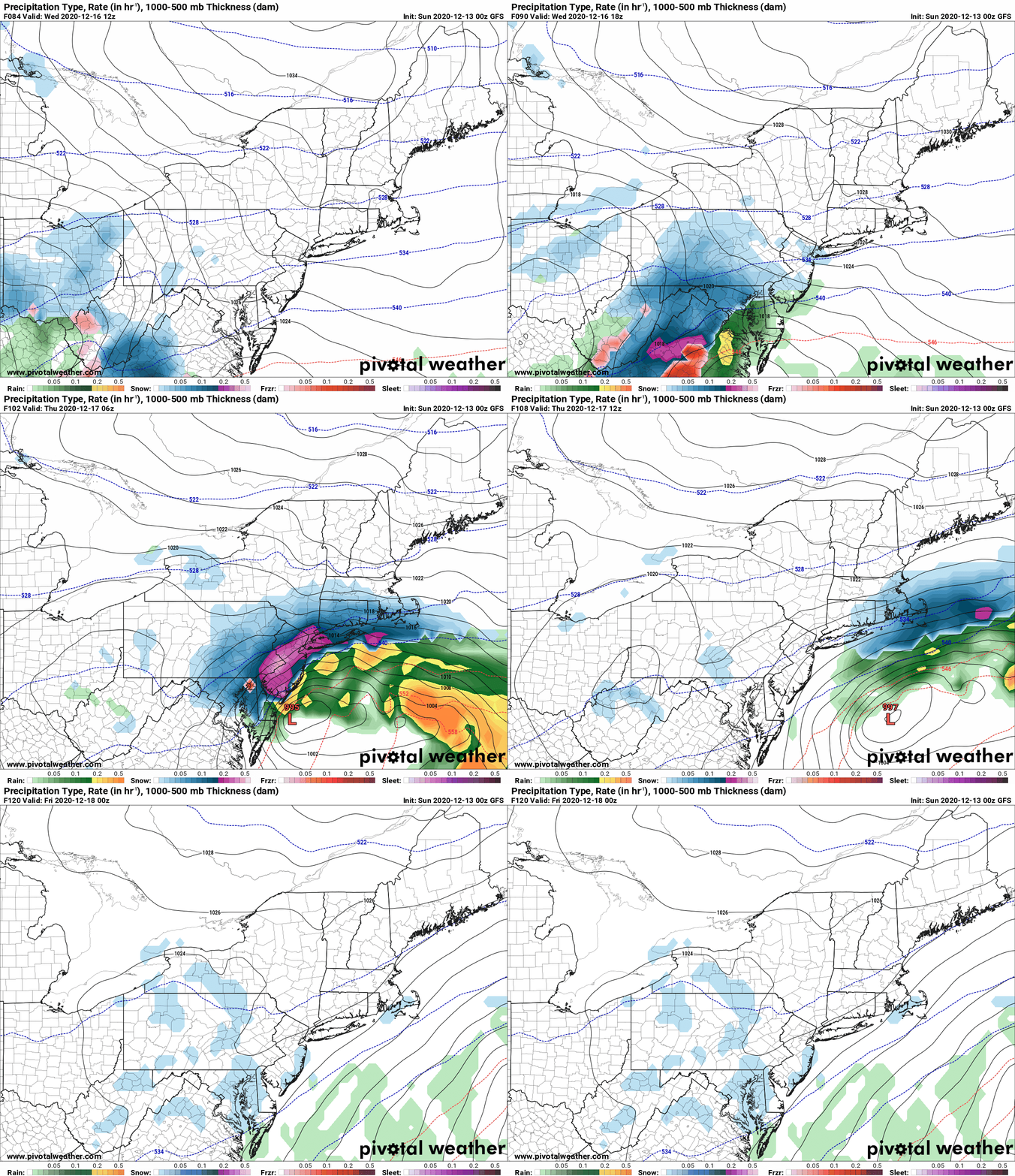
Now to the big show… The upper air maps at 84 hours out, Wednesday morning, both Mesoscale and GFS and Euro showing almost exactly the same pattern, which bodes well for a significant storm on the east coast to develop. Big trough over the OH/TN Valleys swinging east, NW flow to the NE of Upstate NY locking the Arctic High in place (and why you will be VERY cold and dry Tuesday, into Wednesday across Upstate NY), big ridge rolling into the West Coast of the US. From a basic Meteorology pattern, this screams clearly a storm will be coming. That’s no longer up for debate. What’s still the big question mark for Upstate NY: How much and where???
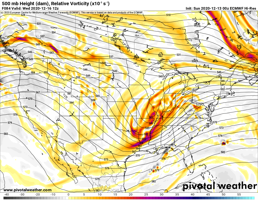
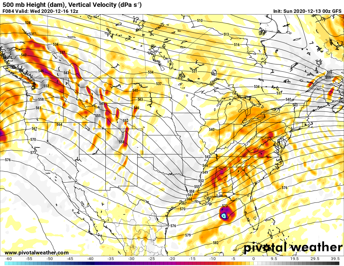
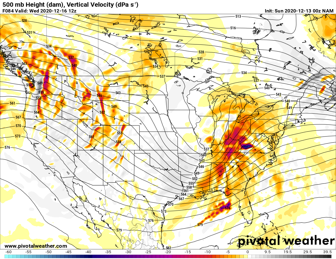
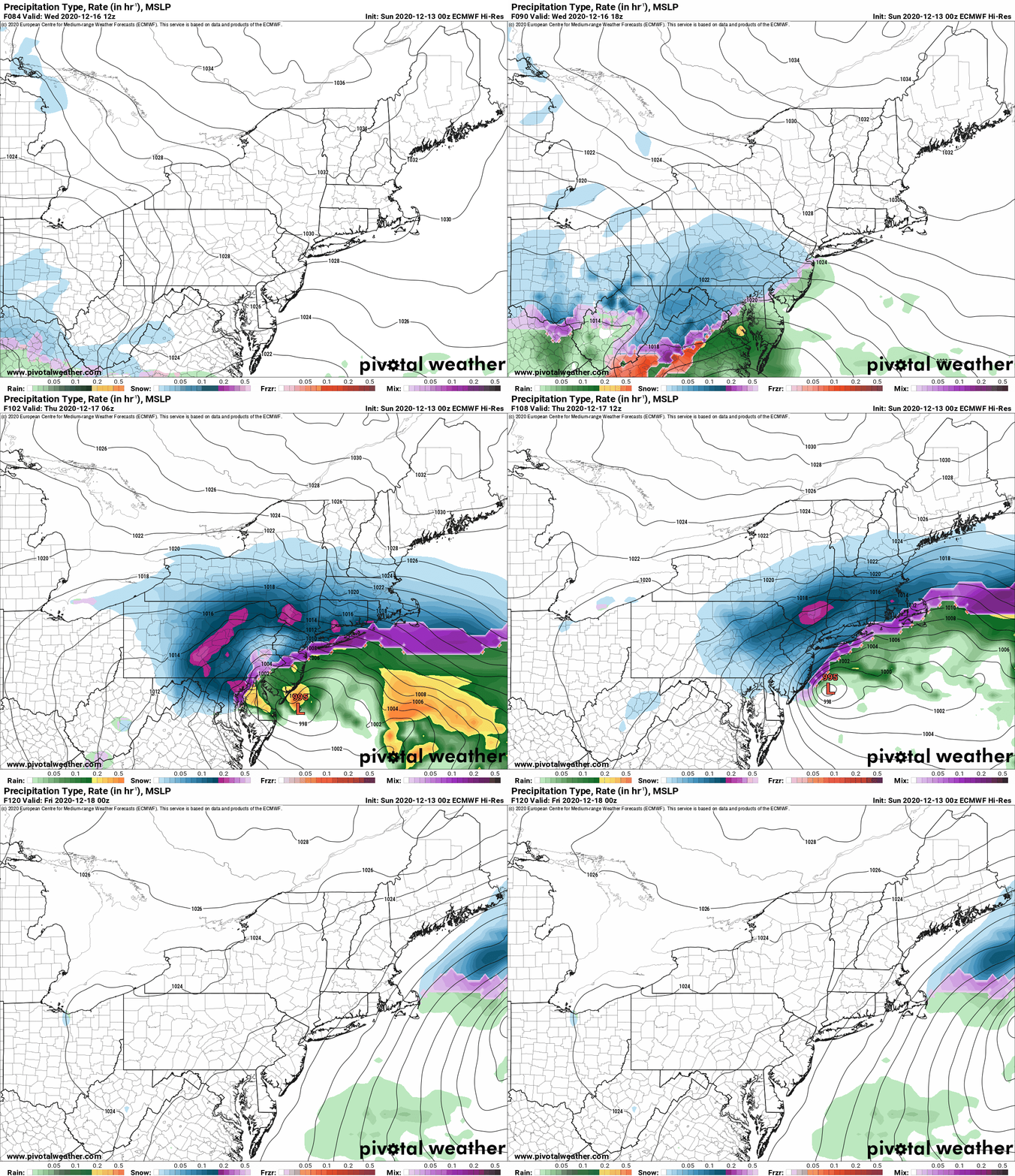
The Euro and NAM are sharper with the trough. The sharper it is, the better it is for Upstate NY. GFS still more progressive as you’ll see below in the Surface and Precip maps.
There looks to be a sharp cutoff to the precip. How far north does she get??? I have enough confidence to say that significant snows are LIKELY Wednesday PM to Thursday AM for the Southern Tier, Catskills, Hudson Valley and most of the Capital Region, especially SOUTH of Albany. Amounts still TBD but I think it’s likely you will need to shovel, plow and/or snowblow this one. The big question area looks to be Finger Lakes, to CNY, to the Southern Adirondacks and Saratoga/Lk George. WNY, Tug Hill, and Adirondacks, especially from Old Forge, MRP, ilsnow land and points N it looks like it could be largely a miss. It still could hit but these areas I would not bet on a lot of snow… yet… still possible but not as likely as points south.
What would make it change to the heavier snows hitting more of Upstate NY???
Where the Monday PM storm ultimately tracks. If it becomes stronger and places itself off the Canadian Maritimes Tuesday into Wednesday, it would force the big Wednesday/Thursday storm to come more up the coast more into Upstate NY. That is what the upper air maps for the Euro and NAM may be hinting at…
If the Monday PM storm moves more quickly off the Canadian Maritimes, that means a better chance the high to our NE becomes the blocker and keeps the storm just far enough SE of Upstate NY to drill PA, NYC area and southern New England with the heaviest snows.
So we wait for more to actually happen and more data before we launch snow maps and start making calls on details.
Upstate Snow Update Schedule:
Tomorrow 12/14 – Morning Blog, if we do a snowmap it will be because of updated snow forecast for the storm hitting later tomorrow afternoon/evening. No snow map for the Wed/Thu storm.
Tuesday 12/15 – First Call snow map
Wednesday 12/16 – Final Call snow map
Thursday 12/17 – Real time analysis/verification of forecast, look ahead to weekend and Christmas week, plus outlook for POSSIBLE first snowmobile rides of the season
*** Please note I am on the road away from Upstate Snow Headquarters through Tuesday PM… so the snow maps may look different as I will be using a different program to make them ***
Podcast Schedule
Tuesday Night – Dave Gleasman is our next Trail Talk Podcast guest.
Next Tuesday – Jim Rolf, Trail Coordinator for NYSSA
Tuesday 12/30 – Special holiday Trail Talk with me and Zack
If we do get rideable snow Wednesday/Thursday, Chris Rinck and I will fire up the “Guide to your Ride” podcast series (remember that focuses on real time snowmobile club reports and weather conditions, different from Trail Talk), and Guide to your Ride runs every Thursday during the snowmobile season to help you plan your weekend snowmobile rides.
Find all current and historical podcasts on the Trail Talk Podcast page on upstatesnow.com
Rich

