Everyone please remain calm. It’s December. It snows. I know it hasn’t snowed much yet this winter and we are all waiting for it now more than usual. Thoughts about what’s out there so far followed by my current analysis…
First of all there is definite potential, no doubt. And the GFS is trending more towards the Euro, which is a good sign… But remember we are 4-5 days out. If the Euro from 10 days ago was right, Upstate would still have snow cover on the ground because many places would have been hit with 6-18 inches. We got a skiff of snow to nothing. The evolution and timing of these storms is critical and what happens with the first storm Monday, will play a key role in the Wednesday-Thursday potential storm. And as always it’s all about that track. I preach this basic Meteorology all the time. I don’t give a crap what any model says… if the surface low pressure doesn’t track in a certain place… the 850mb low, the 700mb low and the 500mb low especially, and if the temp profiles through the atmosphere are not right… you’re not going to get the snow you want, where you want.
I realize 2020 is an alternate reality resembling something like the middle of “Back to the Future 2” but I can assure you, if this Wednesday-Thursday storm is not a Miller B (low coming up Ohio Valley then transfers to coast and develops into a Nor’easter), the snow maps shared online are just fantasy. Take it with a grain of salt until we get within 72 hours… and I also find it ironic that at least a few TV Mets put out model maps like this on the air and/or online 5-6 days out knowing they will be shared like wildfire… they usually complain about such maps being shared hampering their own forecasts and credibility. Model maps are not a forecast! It’s one educated guess on what could happen. Hey it could be right, could be wrong, but I’m not changing how I play. You get snow forecast maps from me at Day 3 at the earliest, which means in The Morning Blog on Monday 12/14 Bro… I will not put anything out until enough model runs, trends show themselves and our mesoscale models (which go out to 84 hours) have a chance to make their case to me. Then I’ll give it my best shot. And it’s my forecast based on expert analysis and experience, not one model.
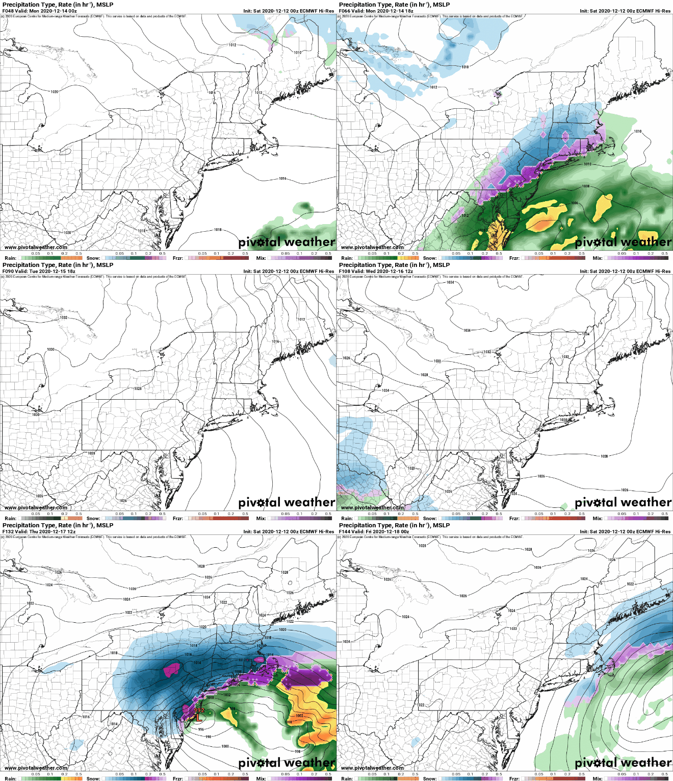
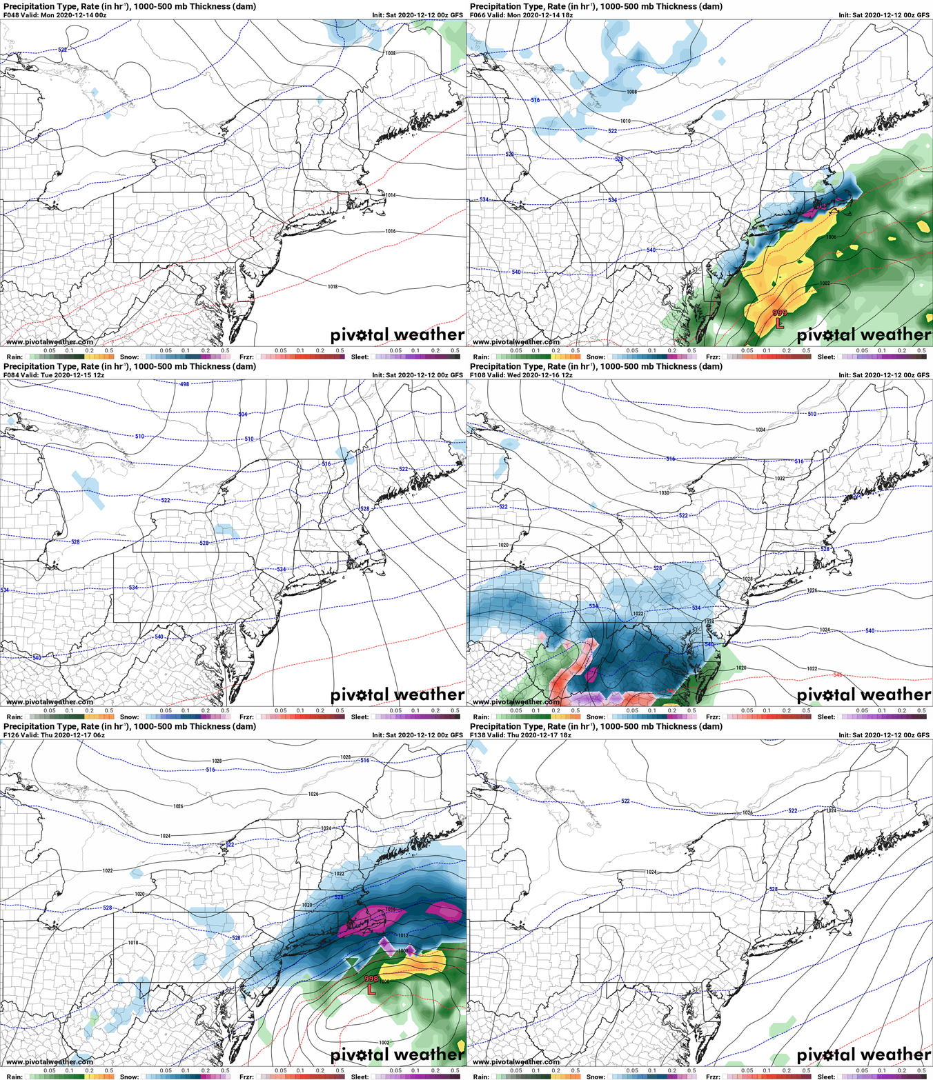
OK so what are the maps showing right now? Euro First then the GFS.

The Euro is farther north than what you will see with the GFS below. But the storm track itself will not result in the widely shared snow map from the Euro on other social media sites especially over the Tug Hill, one of the key areas we cover. Still this is a respectable and very possible scenario. But the timing is off from GFS below… still a lot of things to iron out… and I am suspect with the Low track in a progressive pattern going off the coast, suddenly going back west to touch the Jersey shore, then head east. That’s odd…

GFS is slower and farther south than Euro. Even though solutions are converging, they are converging on a lot less snow N of the Thruway and this being more of a Southern Tier, Catskills, Southern New England hit. We have got to get storm number one from Monday down because it will impact the track and intensity of storm number two. Timing is critical.
Potential yes. Certainty no. Some could get hit big. Other places may not get much. This is time to “stay tuned” rather than panic, celebrate or give specifics. WAY TOO EARLY.
So that’s what I know right now. Sunday morning blogs are always short, and especially since I’m on the road tomorrow. Monday will be first call. Tuesday will be the revision. We’ll see what Wednesday and Thursday bring. Do the snowdance… and BTW… we need SUSTAINED COLD AND A PATTERN CHANGE OR THIS SNOW IS NOT GOING TO HELP. We need both cold and snow for several days to a week plus otherwise any potential riding conditions around the holidays could look more like the Tug Hill SNIRT run, especially with heavy traffic.
Keep Calm. Carry On. Think Snow. Don’t Panic!
Rich


