The most important thing you need to know is this: If you need to travel today in Upstate NY, especially west of I-81, and you haven’t started yet: Drop what you are doing and get started NOW. By this afternoon rain and higher elevation snows shall take over WNY. After sunset tonight it spreads quickly across CNY, NNY and into ENY and the Capital Region. For the lower elevations it should mainly be rain but with so many people on the roads looking to get home, better to get home ahead of them. Above 1000′, the threat for snow becomes much larger tonight but this is not the main event. Yet.
Getting home overnight and getting out Monday Morning will be tricky, especially in WNY as winds there begin to increase quickly. The wind increases hit CNY and ENY midday and into the afternoon on Monday. Our highs which are in the mid 30s up higher to around 40 in the lower elevations actually peak late morning and midday. Later in the afternoon and evening tomorrow, clouds, winds, and snow showers begin to get going.
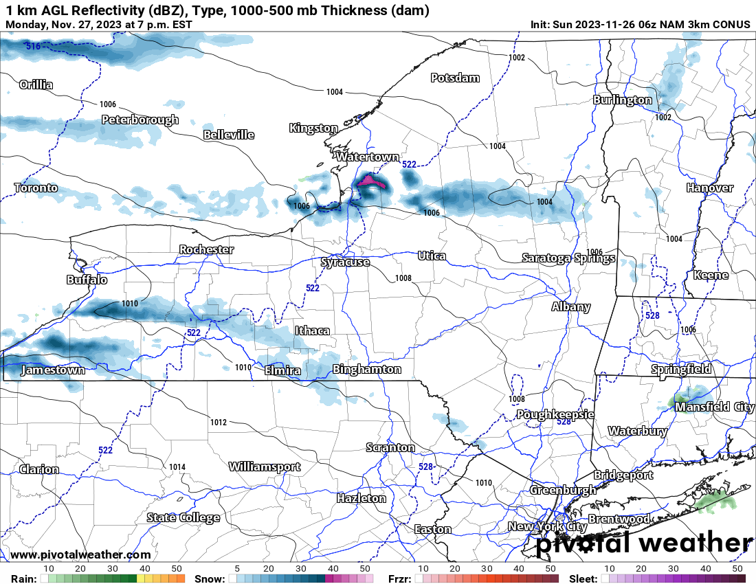
After the sun goes down on Monday Night, it’s PRIMETIME. Over the next 24 hours, the heaviest snows you all have seen since last winter will raid lake effect areas south of Buffalo and especially east of Lake Ontario. Over the Tug Hill, about dead middle to 2/3 of the way N between Syracuse and Watertown, along the Oswego/Jefferson County line, eastbound through Lewis County into Northern Herkimer and Hamilton Counties, the Lake Effect will begin to come down. With authority.
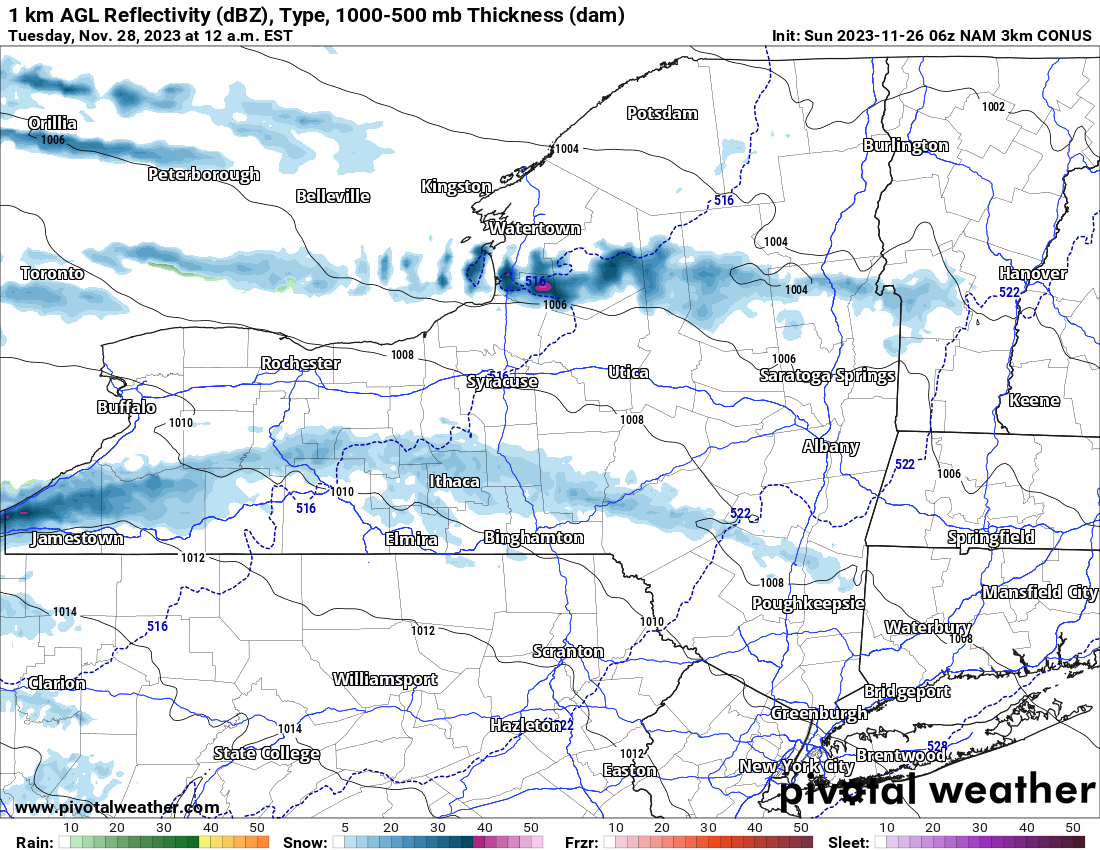
This point I am finding it difficult to believe but all the short range models are going with this. So with that being the case, and with it being 48 hours away, perhaps I should too? Heavy lake effect going south of Buffalo and it goes into major extend mode. Like east of I-81 extend mode. All the way to the Catskills! As for off of Lake Ontario, heavy snows from the Tug Hill through the Adirondacks. If you believe this map, the snow not only reaches the Hudson Valley but goes east into the state of Vermont into the Green Mountains! Not often we say that.
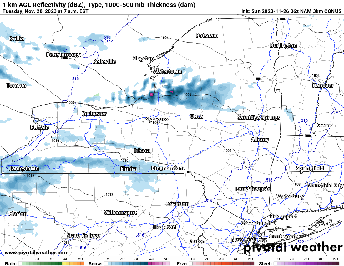
By Tuesday Morning the Lake Effect weakens but with plenty of cold air in place, does not go away. The winds begin to slack off their perfect trajectory and go back W of 81 off Lake Erie and back to Hamilton County, westbound. While snowfall amounts will be decreasing, with the impact of shoveling and snow blowing in lake effect zones in full effect, I would expect the first school delays and/or cancellations of the 2023-24 season to hit on Tuesday.
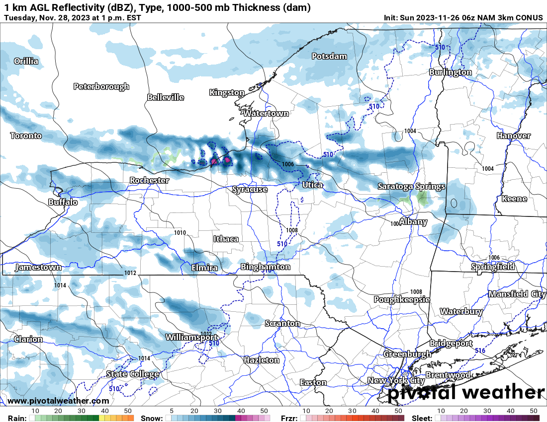
By midday and going into the afternoon on Tuesday, the lake effect is pushing southward. It’s breaking up and not as much off of Lake Erie. Off Lake Ontario, it’s dropping into the Utica/Rome area, down the Mohawk Valley to the Capital Region, and knocking on the door of the Syracuse area.
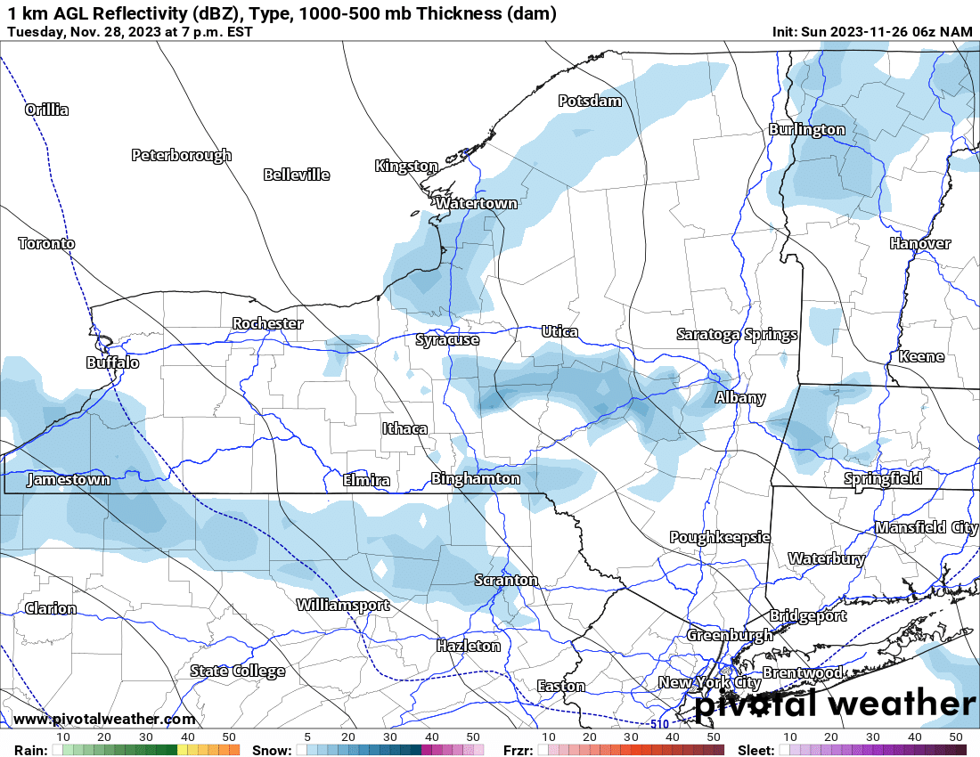
And finally on Tuesday Night with the bands weakening, they are stretched well south of Buffalo into northern Pennsylvania, and through the Syracuse area, south of Utica/Rome back down into the Capital Region, particularly the Albany area. I don’t expect a whole lot of accumulations in these far off places but closer to the lake effect zones, we expect there to be good accumulations. Based off of all the data I have come across, especially since yesterday afternoon, I have made the following updates to the snowfall map:
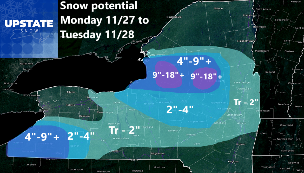
I upped the amounts slightly on the higher end. I went up to 9″ with locally higher amounts south of Buffalo and also off Lake Ontario. In both locations, I see double digit snowfall as an inevitability right now. This particularly off Lake Ontario. Pretty much anywhere east of 81, in Jefferson, Oswego, Lewis, extreme N Oneida, N Herkimer and Hamilton Counties, I expect double digit snowfall out of this lake effect event. While I don’t expect snow totals to get into the 20’s (I still have that out there locally), snowfall totals locally in the teens, particularly between 12 and 18 inches seem fair given all the stuff I am looking at here. Farther to the south over the Syracuse area, Utica/Rome Region and into the Mohawk Valley, we will not be looking at those numbers. 2 to 3 inches, perhaps 4 inches will be the rule. These shall depend mainly on elevation. Towards the Capital Region and Glens Falls, just a trace with locally an inch or two.
This is my forecast set for the storm tomorrow and Tuesday. Sit back, enjoy, and good luck!
Rich


