After heavy rain, thunderstorms and gusty winds today, snow re-enters the forecast starting Saturday PM and goes through Sunday PM. There will also be another period of snowfall, a better period of snowfall developing Sunday evening/night lasting through the day on Monday and into Tuesday as well. The air coming in is the coldest of the season so far, and the devil is always in the details of the interactions. Had I gone for the snow map yesterday it would have been drawn differently. I like waiting that extra day, a few more model runs, especially the mesoscale ones, just to make sure I’m good with the scenario. It paid off. So here we go.
If you are reading on or before Friday afternoon, heavy rain, thunderstorms and wind with the strong cold front is what you are seeing now. It will blow over by tonight. Expect gusts to exceed 40 MPH, especially in the higher elevations. Temperatures will fall during this afternoon and evening quickly. By tomorrow morning (Saturday) we should be close to freezing.
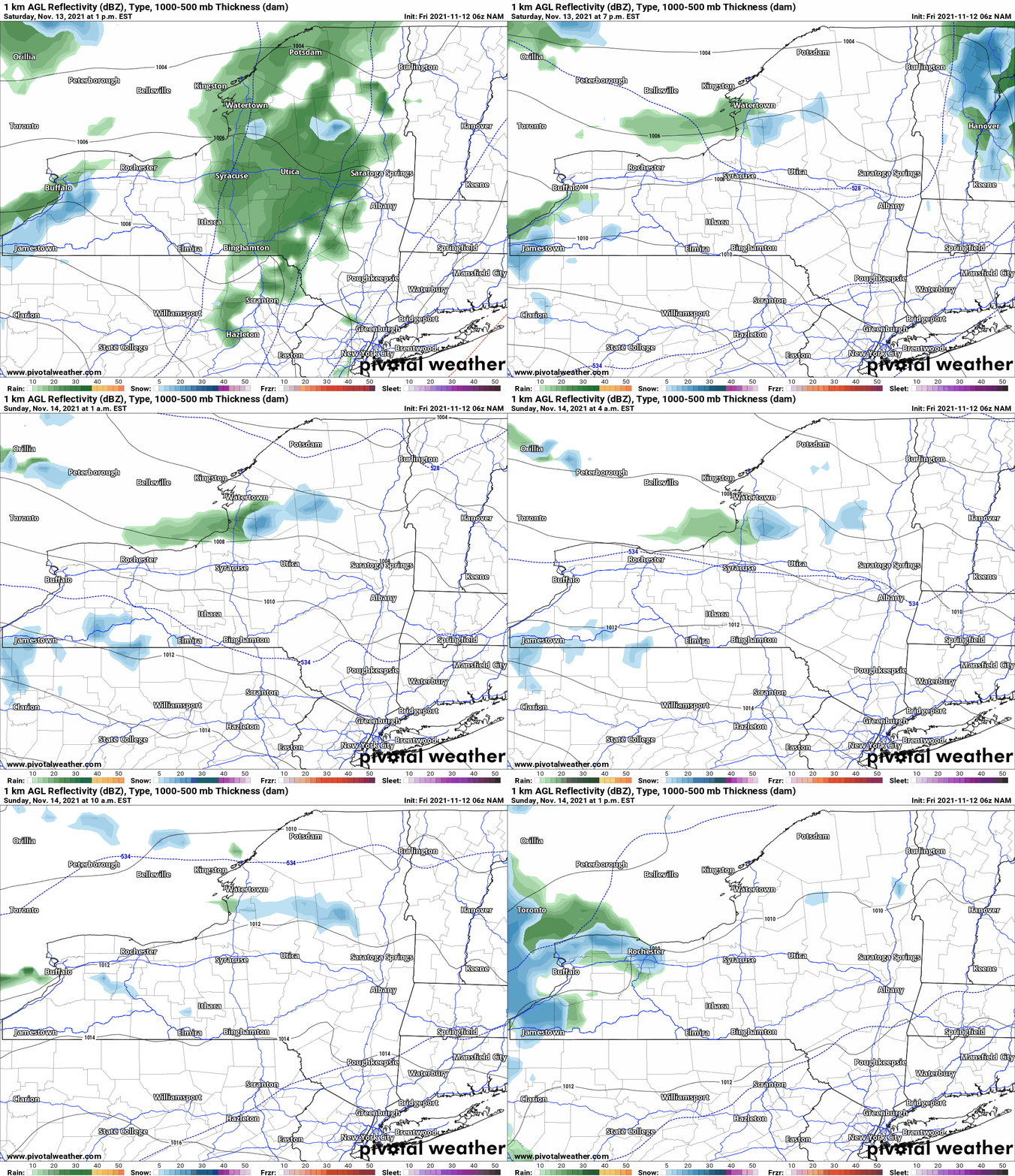
Temperatures do not go up all that much on Saturday as clouds increase and the next system comes through. But the temperatures go just high enough, to kick mainly the lower elevations over to a rain/snow mix or just plain rain. Just 1-2 degrees is all the difference here. Yesterday the air was just cold enough. This morning, not enough. That’s why the snow map is the way it is. This event Saturday PM through Sunday PM will be mainly a higher elevation and lake effect event.
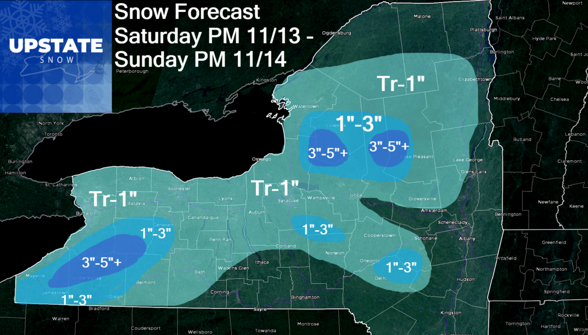
As the colder air pours in behind the next system Saturday night into Sunday morning, this is when most of the accumulations will be. Based on a wind between 260-280, most of Tug Hill Proper, northern Herkimer and western Hamilton Counties (the “snow bowls”), the “south towns” and southern tier ski country south of Buffalo will be in for it on this round. Most of this falls between dark Saturday night and by the time you head to church on Sunday morning. Accumulations of snow are mainly higher elevations and are light. With the fact temps are borderline, I’m still leaving the possibility of up to an inch even in the lower elevations of WNY, the Finger Lakes, CNY and NNY. In all likelihood, probably just flakes at best.
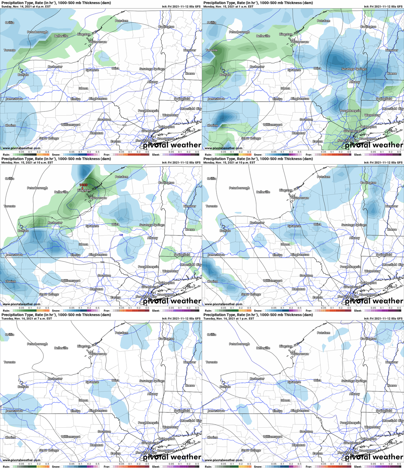
BUT WAIT, THERE IS MORE. The main upper level storm, the actual trough in the jet stream itself AND the heart of the cold air. Cold enough not just to generate additional lake effect snows, but also to produce more general precipitation, mainly SNOW since it will be cold enough not just upstairs but at ground level too, even at the lower elevations. This activity starts Sunday evening, goes through Sunday night and through most of the day Monday. Monday afternoon through Tuesday afternoon, the activity becomes more lake effect in nature. With this being a day 4 going into day 5 event at this time, it violates my 3-4 day snowfall map rule. And for the same reasons I didn’t put out a snowfall map yesterday for this Sunday PM to Tuesday PM event, I will hold this off until TOMORROW. Need to get this all into the mesoscale model ranges and see where the winds will direct the lake effect snow better.
Both events, the snow you’ll see between Saturday PM and Tuesday PM, with that short break during the late morning/afternoon on Sunday between the systems, will not be out of the ordinary for Upstate NY for the middle of November. We are not talking record snowfall, not even close, but enough to where it will make it white, make roads slick and impact travel plans. For the snowmobile clubs, this is more of a nuisance and most of this will not stick around in the long term and build a base, especially on Tug Hill and south of Buffalo.
In tomorrow’s morning blog, I will update (if necessary) today’s forecast for Saturday PM to Sunday PM. I will also put out the next snowfall map for Sunday night through Tuesday for the state. I’ll be within the 84 hour window I like to be in with these snowfall forecasts. Appreciate your understanding and patience with me on this! After doing this for nearly 25 years, no one takes bad forecasts worse than ME, and I just know how much thinking can change when you get too far out. It’s the balance between letting you know (especially because other yahoos put out BIG snow maps WAYYYY in advance), and forecasting off of the best possible information. At this time in 2021, it’s within 84 hours or 3 1/2 days time. That’s the edge of the comfort zone.
Do you like our weather reports, podcasts, videos, and features? Say thank you by becoming a SPONSOR or MEMBER of Upstate Snow! For just $60, sponsors receive a hyperlink to your business or social media page on every morning blog and podcast post on upstatesnow.com for the season (until 8/31/22). For just $10, members get name recognition, or if you wish not to use your name, recognition to your favorite snowmobile club or where you live.
Click below to get started
paypal.me/lupiallc
www.venmo.com/u/Richard-Lupia
THANK YOU to our faithful sponsors and members!
SPONSORS
Southern Tug Hill SnoRiders
Saratoga Snowmobile Association
Ohio Ridge Riders
ILSNOW.com
Enjem’s Flooring America
Water’s Edge Inn – Old Forge
Adirondacks Speculator Chamber of Commerce
White Lake Inn
Toads LLC Fisher and Snow Dog Plows, Cairo, NY
MEMBERS
Chris Rinck
Charles Kleese
Chaz Albertson
Dave Gleasman
John Bates
Darrin Harr
Mark Enjem
Matthew Pistner
Eric Vilovchik
Brian & Paula Bedell
Robert G. Gartley
Chris Higgins
Nathan DeMarco


