March is coming in like a Lion across Upstate NY today, putting an end to the rain and the thaw… but also bringing high winds back to the state with widespread 40-60+ MPH gusts anticipated through tonight, especially across the higher elevations. We will update the thaw coming to an end, the wind and cold returning, where snow chances are best this week ahead, the long range outlook into March, and finally an update about this site and what’s to come for the rest of the season…
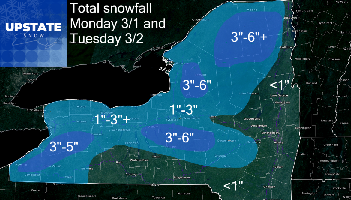
The meltdown ends today as a strong cold front blows through. Literally. Temps will gradually fall below freezing by this evening in most areas, even the lower elevations. As precipitation changes from rain to snow with the colder air, expect icy conditions in many areas late today and tonight. Also expect areas of low visibility with the combination of snow and wind. Expect localized whiteout conditions late today and tonight. Precipitation will be lake effect snow, some wrap around moisture and upslope or orographic snow. Because this is cold dry air coming in from Canada, and very high winds reducing residence time over the lakes, amounts will not be significant, but enough for one more snow map. Adirondacks, Tug Hill, the hills south of the Thruway along route 20 and south of Rochester/Buffalo should get at least a few inches of snow, locally higher amounts especially N of the Thruway in the colder air and greater upslope potential.
Winds calm down tomorrow but still breezy with lingering lake effect snow showers. Localized squalls still possible downwind of the lakes. Temperature staying below freezing will give groomers and clubs tomorrow a chance to clean downed branches off the trails, work in any new snow, and repair damage done by the thaw this past weekend. Always check with clubs first as we say, but it’s a given with the recent thaw, weather changes and winds, riding either today or tomorrow will be challenging and conditions nowhere what they were. Heads up on that.
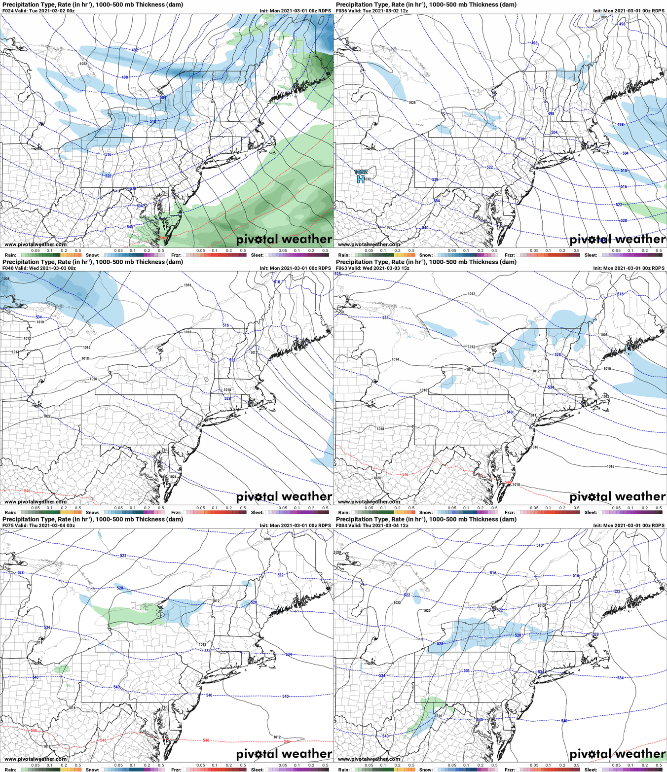
Another weak clipper zips through Tuesday Night through Wednesday with additional snows mainly focused north of the Thruway. A general few additional inches of snow is likely for the Tug Hill, Adirondacks and North Country, with several inches where any lake squalls and upslope flow establishes itself. More snow showers may continue N of the Thruway on Thursday, but the trend over the second half of the week and towards next weekend will be for fair skies, quiet weather and not just below normal temperatures but below freezing temperatures. This is great news for sustaining the remaining snow pack we have, and giving clubs a chance to make one more nice late week/weekend ride in areas that do have sufficient snow left to groom and whip back into shape. Unlike the last six weeks where conditions have been amazing across most of Upstate NY, as we like to say, the playground is shrinking. Epic cross state rides we haven’t had for years are going to be very difficult, if not impossible, to accomplish now after the damage assessment from this thaw and any blowdown. From this point forward, you can still rip off a few hundred miles a day, but you are likely to be more limited to North of the Thruway. From this point forward, check with clubs, plan rides carefully, and beware conditions will not be as amazing as they have been.
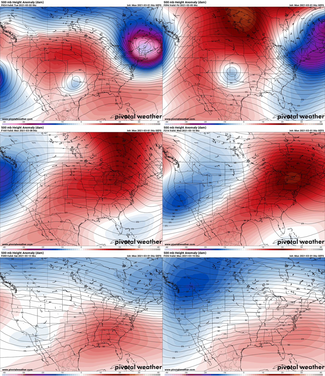
The great Yogi Berra said it ain’t over until it’s over. But I am just telling you it’s the 9th inning, we’re down several runs, facing Rivera as the closer, and the bottom of the lineup is up to bat. Translation – Our miracle run of truly awesome winter weather is coming to an end. The weather pattern for the first two weeks of March bares very little chance of any big storms or Nor’easters to save us. No huge cold blasts coming after this week. Odds are high the springtime warmth that will take over much of the central US late this week and this weekend will head its way towards the east coast and northeast in the second week of March. The ensembles are clear the upper level low to our east off the Canadian Maritimes, responsible for the NW flow and constant below freezing temps this week, will eventually weaken and give up. With no cold air left in Canada to unload and a big central US ridge, odds are high next week will switch back to above normal temperatures. All ensembles are indicating this, not just the GFS. Given the long range, I say next weekend is your best chance for longer rides N of the Thruway, and as we approach mid-March riding will continue to go down across the state with the usual hideaways on Tug Hill and in the North Country and Adirondacks hanging on to localized areas to ride through the middle of the month. Based on this pattern, chances are better than 50/50, all riding in the state, even in die hard areas up north should conclude by third week of March. But it’s still the 9th inning. The game isn’t over yet. Yes things may change and we get something mid to late month that gives us one last hurrah. It’s always possible in March. I’m saying while possible, not likely. Get your last good rides in between Wednesday and Sunday. Anything after that is gravy.
I’ve mentioned in previous blogs and FB posts that I’ve been dealing with some health issues that have kept me from regular updates. I’m very sorry to all of you I have not been able to update as I planned. This winter has been difficult for me personally on many levels. While my health is on the road to recovery, I still have several weeks to go before I’m back to what you would call 100%. Obviously by that point, the season is over. So I wanted to let you know now, this is likely to be the last formal “Morning Blog” of this season. If I’m able to do another, I will. But don’t count on it. From this point forward, updates will continue on the Upstate Snow Facebook page. If you have not liked or followed it, please do. I have enlisted Chris Rinck President of Southern Tug Hill to make sure any major weather information of note is shared to the site from sources we mutually trust. I encourage you to also follow Darrin at ilsnow.com, Bill Kardas at WKTV and Jeremy Kappell at WxLive. All three are excellent Meteorologists and close, trusted friends.
Thank you to all of the snowmobile clubs and NYSSA for your support of the podcasts and weather updates this past season. As I have stated to them privately, and to all of you publicly, this platform is dedicated to serve winter weather lovers from (or visiting) Upstate NY. This platform has been and will be about giving honest weather forecasting, giving a positive media voice to the snowmobile community, and promoting all that is good about winter and snowmobiling in Upstate NY. This would not have been possible these last 9 years without YOU. I can never thank you all enough for this project to come to life and blossom these last 9 years. You are what drives me and makes this site what it is. THANK YOU!
Next season will be out 10th and will be by far our best ever.
I AM NOT GOING ANYWHERE. NEITHER IS UPSTATE SNOW. PRESS ON AND PERSEVERE!
Rich Lupia
Owner/Operator
Upstate Snow
March 1, 2021


