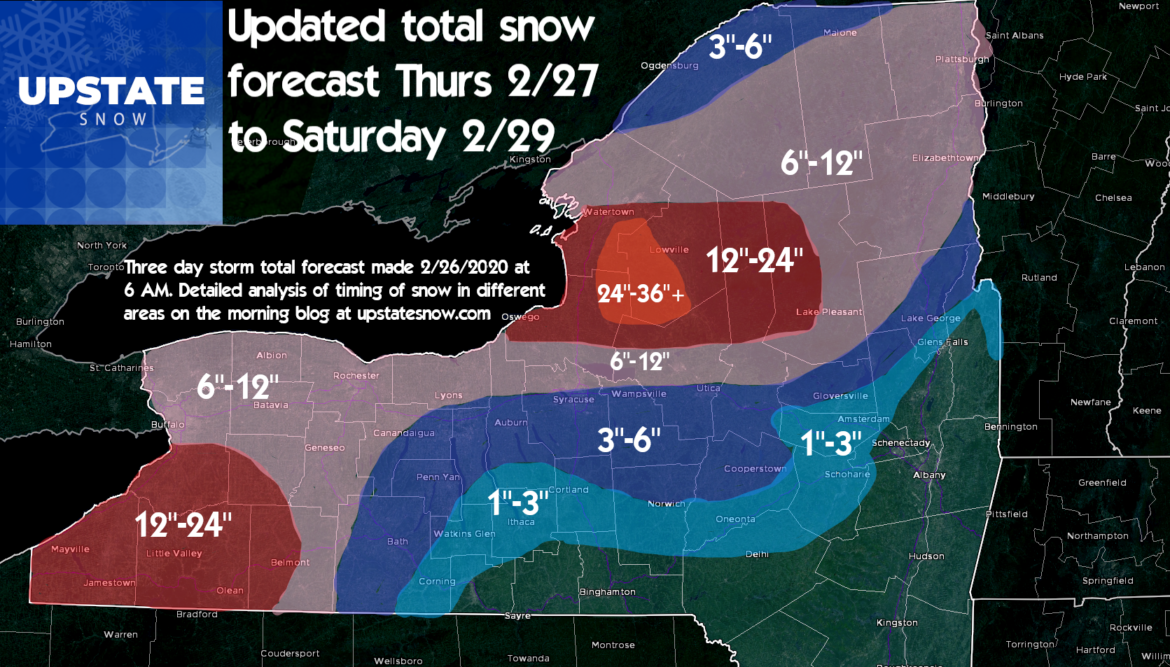
We can now give a little more detail on what we think will happen with the initial storm and significant lake effect snow to follow. This is not the final call… still 48-72 hours out on the heaviest lake effect snows (as of this 6 AM 2/26/20 blog time) and slight changes in the storm track and wind could decrease or increase totals for certain areas.
What has changed: Greater confidence in storm track and quicker switch over to snow for areas of Western NY, driving up snowfall totals from yesterday’s first call. Also, greater confidence in the strength of lake effect snowfall bands Thursday PM through Friday PM in the Southtowns S of Buffalo and over the Tug Hill and Adirondacks. Confident enough now to put the Old Forge area, western Adirondacks, Moose River Plains and Perkins Clearing areas (Generally N of route 8 and W of Route 30) into the 1 to 2 foot storm total range.
Important note for travelers: Wind threat and threat for blowing and drifting snow INCREASING. In some circles the “B” word has been thrown around. That B word (Blizzard) has nothing to do with intensity of snowfall or snow amounts. For “Blizzard Conditions” winds must be sustained 35 MPH or greater with less than 1/4 mile visibility for at least three consecutive hours. While I don’t think it will be seen on a widespread basis, there will be some areas, especially more wind prone and open fields, that may experience near blizzard conditions. This is especially important for those traveling Thursday and/or Friday. Thursday the greatest threat for this is anywhere west of I-81 and around the Tug Hill. On Friday during the height of the lake effect snows, anywhere downwind of Lake Erie or Lake Ontario within the snow bands.
Since we cover Upstate New York and there are so many areas of interest to this audience, I will give you my best analysis on what to expect where and when by area/region. In no particular order:
Tug Hill: Ground zero. Heavy snow Thursday AM, winds kick up quickly during the day. Transitions to heavy lake effect squalls Thursday night through Saturday. Winds may change from time to time so different areas of the hill will get hit harder than others. Those minor changes are too hard to call this far in advance, but in general, the hill proper should have no trouble between the initial storm and lake effect squalls to follow hitting 2 to 3 feet. My thought yesterday of one location possibly breaking 40″ is still very much possible for one lucky hamlet on the hill. Use extreme caution if you try to ride during the storm.
Old Forge/Boonville/Forestport/Brantingham/Big Moose/Stillwater/Inlet/Moose River Plains/Perkins: Initial shot of snow thursday AM will be respectable at a half foot or more. The lake effect here looks to be most intense Thursday Night and Friday Night. Again the band will move a little so not all areas will get hit hard at the same time. Those that get hit, will be hit hard at 1-2 inches per hour. Strong gusty winds as well. Use extreme caution if you try to ride during the storm.
City of Buffalo, Northtowns, Orleans, Genesee Counties, Greater Rochester area: Most of your snow will hit overnight tonight and Thursday during the day. Expect snow to taper off during afternoon. While some lake effect is possible in these areas, most of your 3 day snow total will be done by dinnertime Thursday. Winds will be STRONG, 40-50 MPH at times, blowing and drifting snow will be a major issue.
Southtowns (S Erie County), Chautauqua, Cattaraugus, Allegheny, Wyoming Counties: Everything Buffalo/Rochester gets hit with plus another round of lake effect snow, locally heavy at times, with gusty winds and blowing and drifting snow. Best window for the additional lake effect snow that will push your three day total into the 12″-24″ range, will be Thursday PM through Friday PM.
Finger Lakes region (S of I-90), Southern Tier, Catskills: Most of your snow hits with the main storm overnight and into Thursday. Tapering off by afternoon. In these areas accumulations will not be as much (see map) but the snow combined with wind will make travel difficult on Thursday. Most of Friday and Saturday quiet although snow showers on the edges of these lake bands can’t be ruled out.
Thruway Corridor from Auburn to Syracuse to Utica and Little Falls: This area has the highest bust potential on the forecast. Why? As the rain changes to snow early Thursday AM, it will be just enough for a few inches of snow to mess up the Thursday AM commute. Winds will cause issues too. There will be a break Thursday PM and into Friday most of the snow will stay just to the N. Rome will get more than Oneida and Utica. Central Square will get more than Fayetteville, etc. Some lake snows will make it here, and I think the best chance will be Friday Night into Saturday as winds shift more NW as the storm departs. Snow totals will vary locally. This zone within 10-15 miles north or south of the Thruway could see anywhere from several inches if the changeover happens quickly and lake snows come farther south, to barely enough to shovel if it stays rain and doesn’t change quick enough Thursday AM while lake bands stay N through Saturday AM.
Mohawk Valley Little Falls to Amsterdam and foothills to the NE of there into the Eastern Adirondacks. Most of the snow will hit Thursday AM although the lake bands could touch here briefly. Again this is on the edges.
Capital Region and south: Sorry. Game over is you like snow.
Stay tuned for more updates!
Rich Lupia
Meteorologist and owner of Upstate Snow


