
Holy cow! Holy ice! Holy wind! Holy snow! Holy holy!!! Winter has gone NUTS over Upstate NY and will continue to do so over the next several days. If you haven’t already, today would be a good day to make sure that you have all portable electronic devices fully charged, batteries for devices that can run on them if the power goes out, and extra tons of blankets in case the power does go out for days 🙁
This is not the opening paragraph I wanted to write today. But it is one that I must. A very strong storm will be approaching and will make its way basically over the state tomorrow. As it leaves, very strong winds will follow behind it along with rapidly falling temperatures and tens of thousands, if not more, likely to lose power. For several hours to a few days with temperatures in the single digits and teens. This is not cool. Get ready!

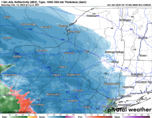
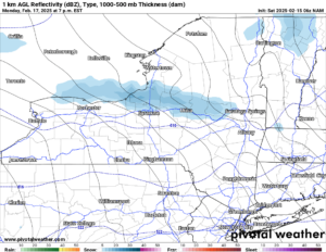
2 PM Saturday
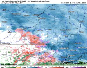
8 PM Saturday
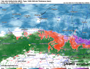
5 AM Sunday
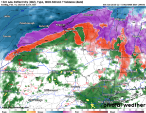
2 PM Sunday
SNOW MAP
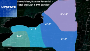
Here is how the storm goes: It starts as all snow in the coming hours. In fact when you are reading this it will probably be snowing if not accumulating already. Steady light snows, to at times moderate snow, hit this afternoon and tonight. During the night is when sleet begins to move into areas south of the Thruway. After a time of sleet, freezing rain will move on in by daybreak Sunday morning for areas south of the Thruway. Along and north of the Thruway it will be a mix of snow and/or sleet. For now.
Sunday morning it turns to all sleet and freezing rain, with the exception of the North Country and Adirondacks that stay mainly snow with just a little sleet at times. Freezing rain mainly with some changing to rain for a time from the Mohawk Valley and the Thruway corridor and points south. This should definitely keep the accumulations lower in this part of the system. For now. Sunday afternoon the 980 something low approaches and then moves right over Upstate NY. This is when the system is about to rear it’s ugly head. Because once the low moves to your east Sunday afternoon and into Sunday evening across the state, it’s GAME OVER.
8 PM Sunday
8 AM Monday
1 PM Monday
7 PM Monday
SNOW MAP 2
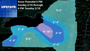
Now we have reached part 2 of the storm. This is the bad one. The mad one. This is the type of storm we don’t like to talk about or live through. This is when the strong winds come in, the temperatures plummet, and snow takes over with blowing snow and additional accumulations. The biggest thing is the winds from Sunday Night and into Monday, President’s Day. These winds will be STRONG. Steady 20-40 MPH winds are imminent for about 24 hours. Gusts of these winds will be at least 50 MPH or more. Top wind gusts could reach 60 MPH. This will take a lot of limbs and branches down all across the trail systems. Seriously. If you wanted to ride Sunday Night and on President’s Day, DON’T. There will be tree limbs and branches down EVERYWHERE. There will be all kinds of power lines down. All kinds of people will be without power. With the winds being how they are, it will take potentially a few days to get most everyone back up.
Now as for the weather itself, it’s brutal. Snow and blowing snow. Accumulations as you see will be on the order from a few inches to several additional inches, especially downwind of Lake Ontario. It falls into the teens quickly by Monday morning then generally stays in the single digits and teens for the next 48 to 72 hours after that. At times the lows will dip below zero especially north of the Thruway. At times it may get into the 20s but low 20s at that and at the lower elevations. Windchills most of the time from overnight Sunday, through Monday and Tuesday will be BELOW ZERO. Please folks, bear this in mind with anything you are planning on doing. It will be rough. We haven’t seen weather like this in a decade. Since February 2015 was the last time we saw weather like this on this scale. Get ready for it!
7 AM Thursday 2/20
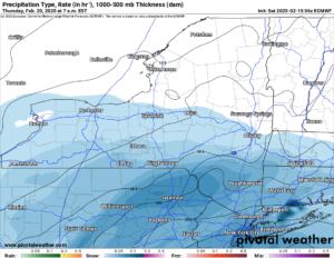
1 PM Thursday 2/20
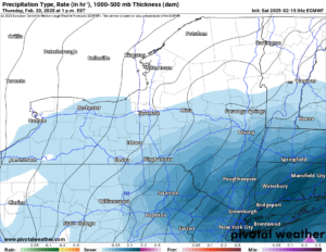
By the middle of next week things dry out and the winds calm down, at least for a time. Then Wednesday Night and into Thursday, the next storm system comes running up the coast. This will likely be a big storm. If you are to the south and east of Upstate NY, particularly in Pennsylvania, Maryland, Virginia, New Jersey, NYC area and Connecticut, you will see much different weather than we will here. You could potentially see the biggest storm you have seen in 10-15 years! We are talking a serious Nor’easter with the potential for FEET of snow. Not inches… FEET! Like 1-2 feet on average with some areas pushing 3 FEET. We are into that rare air here too! What about it’s impacts on Upstate NY? Nowhere near as bad. We will be on the edge. At this time, Binghamton to Albany and points south and east of there will get accumulating snow as in shovelable and snow plowable snow. Even at that we are only talking inches, not feet up where we are.
After that storm goes by, at the end of next week, things actually turn QUIET. FOR A CHANGE! The sun actually breaks out. Temperatures and winds don’t go crazy, if anything remaining below normal but not as bad as it could be. And we can actually take a break. For a few days. From one of the craziest weather patterns we have been in, for a long time.
SNOW COVER WILL NOT BE A PROBLEM. PRETTY MUCH OVER MUCH OF NY.
We will still have low snow cover issues mainly over the Hudson Valley, Southern Tier, Finger Lakes, Genesee Valley and into parts of Western NY. From Central NY and the Capital Region and points north into the Tug Hill, Adirondacks and the North Country, the snow cover will be DEEP. Snow packs will be measured in FEET like 1-2 feet for many areas with up to 4 to 5 feet in the heaviest snows in the Tug Hill and Adirondacks. We have not been able to dream like this for a long time.
SO WHAT ARE YOU WAITING FOR? RIDE RIDE RIDE!
Because at some point, mother nature will turn. Temperatures will warm up. Snow will start to melt. And eventually all of this will melt away. It will take awhile, and if it melts too fast, we could be talking about serious flooding issues. Just pray that doesn’t happen.
Zack and Rich Lupia
Upstate Snow
February 15, 2025
Please thank our advertisers on Upstate Snow for 2024-25
Banner Sponsorship
Great Lakes Equipment
Enjem’s Flooring America
Ohio Ridge Riders
ilsnow.com
Southern Tug Hill Sno-Riders
Saratoga Snowmobile Association
Business Sponsorship
Wedge Life
Paton & Son Excavating and Landscaping
Personal Sponsorship
Jim and Colleen Andre


