Hey there everyone! I am BACK!!!
I know these weeks have been difficult for you. You have not known where I have been. Taking off after my best 3 month swing in history. The weather turned warm. Again. Then warmer and warmer. By the end of last week, we were not only in record territory, but record smashing territory. How the heck do you keep snow around when temps are in the 50s to even 60 degrees? Any time of year?
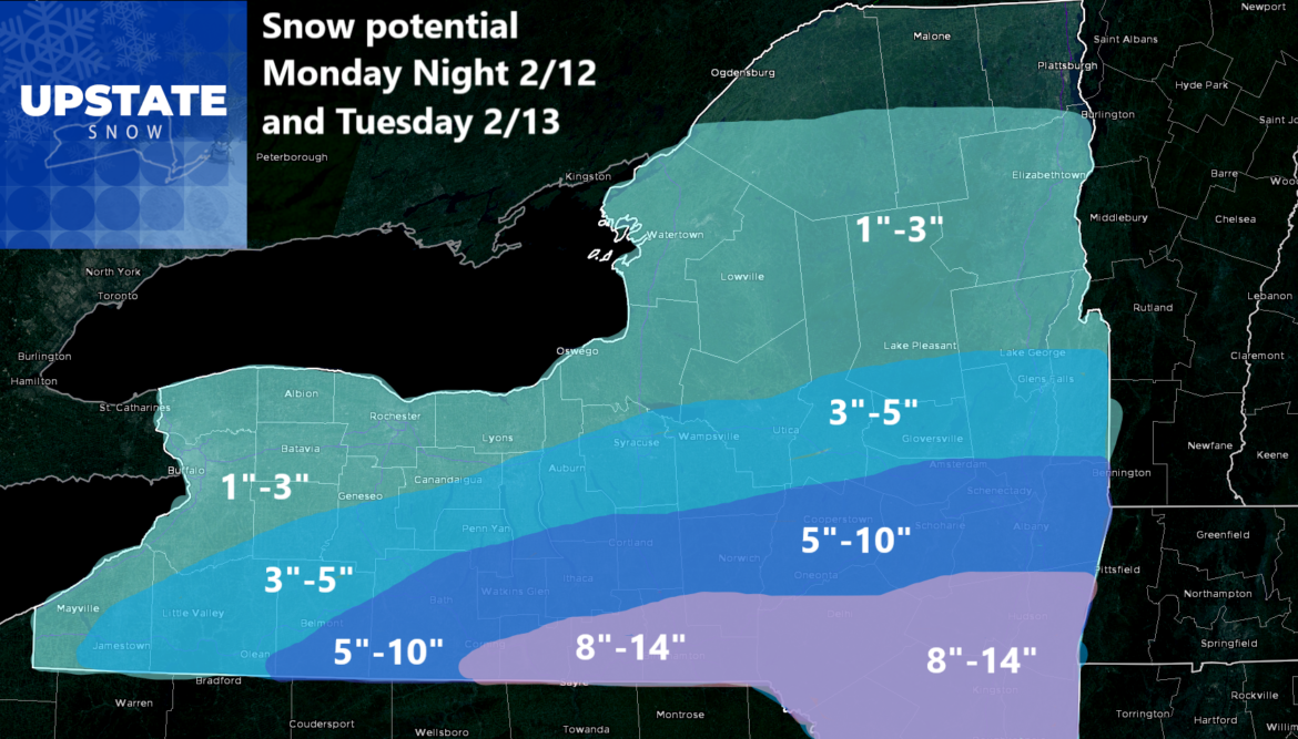
Well I have some good news. After three straight days of record smashing temperatures. After thunderstorms with widespread reports of hail around Upstate NY yesterday, a near unprecedented event for February, we have passed the pinnacle and are starting to come down the other side of the mountain. Yes it will still be above normal today and tomorrow, but tomorrow night and into Tuesday, for the first time in nearly a month, we actually have an accumulating snowfall event to talk about. Then it’s around normal temperatures the rest of the week. Given that “normal” is the new “below normal” we will take that.
So lets start with the clouds now. For the next 36 hours, expect clouds with little to no sunshine or breaks in the clouds. It will continue to be above normal but nowhere near where it was in the days before this.

The Monday Night into Tuesday comes along. And the first snow event in nearly a month. This one has been altering almost on every single run over the last several days. On some runs, barely any snow hits the Southern Tier and Catskills. On some runs, the heaviest snow gets draped across Central NY through the Capital Region and into the Southern Adirondacks. It is looking like at Day 2-3 time frame, the snow will fall in between there. So for the Southern Tier, Catskills, Hudson Valley and up to the Albany area, you will have the best chance at a decent snowfall out of this. What do I mean by decent? Over 6 inches. Which puts us into Winter Storm Watch territory. Which is where we are right now. Farther to the north over the I-90 corridor, especially from Syracuse to Utica/Rome, less snow will fall. Farther north into the Tug Hill and Adirondacks, light snow will fall. For these particularly heavy snowfall and heavy snowmobile areas, this is not good. And this should pretty much wipe out any recovery in time for President’s Day Weekend.
After this storm passes, two days of sunshine follows for Valentine’s Day and for Thursday as well. Temperatures will finally correct to around NORMAL which is 20’s in the Adirondacks and Catskills to near freezing across the lower elevations of Upstate NY
The next system approaches on Friday and into President’s Day Weekend. This is traditionally one of the biggest weekends to ride all year long. It also has the most ice on the lakes. Neither will be true this weekend. Stay off the lakes and treat any snow you have left around you gingerly with great care. If you have enough to ride, please don’t brap going 0-80 in 4 seconds and wiping out what little if any snow we will have. Gently. Gently. Gently. That’s the way to go when the snow is low.
Below normal temperatures are expected beyond President’s Day through the end of February. Does that mean 20’s? Does it mean much colder? Does it mean the back 9 of winter finally comes about? Well, we will just have to wait and see in the coming days shall we?
To all those who look at the site and normally follow this page: THANK YOU SO MUCH for these past 3 1/2 weeks I have been able to take a break and time out here. It has been welcomed and treated with great respect, but I also want to get back on here and get whatever is left of the season done. Strong El Nino’s always win. They always bring below average snowfall and above average temperatures. Always. It happened in 2015-16. It happened again in 2023-24. 5 years running for low snow winters. My gosh! Someday we will come back to the heavy snows and bitter cold we once knew. It hasn’t been in the 2020’s. Yet.
Rich Lupia
Upstate Snow
February 11, 2024
BTW – Chiefs for the Super Bowl tonight 🙂


