
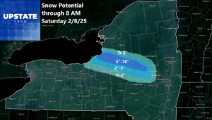
Snow and wind continue today and tonight downwind of Lake Ontario across Oswego, Oneida, Herkimer, Fulton and Montgomery Counties. Not much elsewhere. Tomorrow night and into early Sunday Morning, snow, heavy at times, hits all of Upstate NY with decent accumulations.
Part one was done yesterday and we got the amounts about where we needed them. Today is more difficult as we are dealing with snows downwind of Lake Ontario with stiff winds of 30-50 MPH. When winds get to this range, it has a tendency to help shear apart and break apart the snow bands so they are not as heavy. That is indeed what we are seeing today as we are looking at the doppler radars across Upstate NY, particularly the Binghamton and Montague sites.

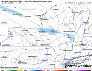
The snow will continue down this 280 degree path that has been set up. It will be steady. As the winds start to die off some this afternoon and especially this evening, we may get a few really good bursts of snow. But these snows will be localized within the lake effect snow bands. And limited to within 5-10 miles of where the center of this line is. Again, I hate putting up tight maps like this because one false slip or “the wind shifted” can blow the whole thing up! In any case, the forecast numbers through the overnight tonight and into early Saturday Morning.
During the day on Saturday it will be a cloudy day. Nowhere near as breezy to windy as it is now. That’s a positive! But with hardly any sun, Saturday will be just a grey day. Visibility will be good. It should be a great day to ride anywhere you can across Upstate NY where riding is available. Some of the best trail conditions of the year. Get out there early!
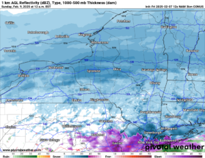
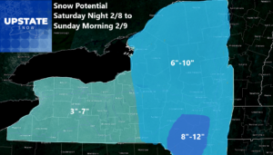
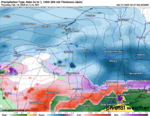
Then Saturday Night and into early Sunday Morning, the next storm rolls in. This one is a good one. This is a very strong clipper to Saskatchewan Screamer! This will bring snow, heavy at times, for several hours! An average of 1″ per hour is the expected rate, especially east of I-81 where I have the higher snow totals by Sunday Morning. And in the Catskills, this is where the new BULLSEYE is looking to take shape with some areas approaching a foot of snow!
After that heading through the rest of Super Bowl Sunday it remains cold and dry with just scattered snow showers with little to no additional accumulation. It remains the same Sunday Night, through Monday, through Tuesday, and through most of Wednesday as well. But late Wednesday, especially Wednesday Night and through the day on Thursday, that is when the next storm will move on in with more snows and with additional accumulations.
And there is even more after this storm. Since we get this into Day 7-10 range, I don’t like to show maps that far out. Just because it can show big snows or big things and gets tons of views, shares, and create all kinds of commotion. That is not how I play. All I can say is from Valentine’s Day through President’s Day Weekend, expect more snows, more potential accumulations, and the big snowbanks that you have outside to get even bigger! Are you wondering if we will just keep contributing to the snowpack until we are all iced in for eternity? NO. March is coming with its higher sun angles. And once we break this crazy snowy weather pattern we are in and things turn, the snows will wind down fast. I have seen this over my decade plus at Upstate Snow. Trust me, when that day comes, it is a sad day for everyone who loves to ride snowmobiles. It is when we all get our last rides in, then pack everything away for “summer sucks” season.
Zack and Rich Lupia
Upstate Snow
February 7, 2025
Please thank our advertisers on Upstate Snow for 2024-25
Banner Sponsorship
Great Lakes Equipment
Enjem’s Flooring America
Ohio Ridge Riders
ilsnow.com
Southern Tug Hill Sno-Riders
Saratoga Snowmobile Association
Business Sponsorship
Wedge Life
Paton & Son Excavating and Landscaping
Personal Sponsorship
Jim and Colleen Andre


