
Good morning. I am here. I am sorry I was not around during the decent snow event we had Tuesday Night and through Wednesday. It was a difficult time for me and I am sorry I was not there for you.
It always figures that during one of the bigger snow events of the year, something like that would happen. And it did. But I am here today and will report on what actually happened, where we are now, and where we are going from here.

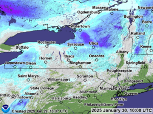
Snowfalls pushed 1/2 foot (6 inches) or more to the north of the Mohawk Valley, mainly over the Tug Hill, the Western Adirondacks, and the higher elevations of the North Country. Also some areas south of Syracuse, particularly Cortland and Chenango Counties got in on the near to over 6″ sweepstakes. This will help the going snowpack across the state.
Where are we now? We are doing well between I-81 and the Capital Region/Hudson Valley. Snowfalls of feet in depth are still very much common place across Oswego, Oneida, Herkimer, Lewis, Jefferson, Hamilton, St Lawrence, Franklin, Essex, Fulton and Montgomery Counties. Not over all of them but over a lot of those counties. In the lower elevations of those counties, the snowfall amounts are lower but it would still be rideable. The next tier is in the 6-12 range of snow with areas up to 18 inches, which includes Onondaga, Cortland, Madison, Chenango and Otsego Counties. There are some low snowpack challenges in spots on these trails. Looking west of I-81 into the Finger Lakes and the Genesee Valley, where is the snow? Seriously! Every time it is predicted it seems to pass by. Western NY, especially south of Buffalo is doing well with Lake Effect especially with Lake Erie having gone from near record warmth 60 days ago, to frozen today.
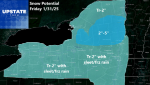
Here is what is coming up next: After todays sunshine and increasing clouds this evening, snow develops overnight. It will be a light snow, not a heavy snow like in previous events this month. To the south of the Thruway tomorrow morning, it will mix in with sleet and/or freezing rain. Will it be a lot of it? No. Will it be enough to cause problems and slick spots on your Friday commute? Probably. Just bear that in mind. It gets warm enough to turn this to rain for a few hours in the afternoon, especially in the lower elevations, before the cold changes it back to snow Friday evening then it ends overnight and by dawn on Saturday. During the day on Saturday, expect a partly sunny but very cold day.
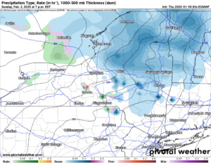
Sunday, especially in the afternoon and evening is when the next snow event comes about. Just in time for Groundhog Day! And just a hair too far for forecast numbers here for now. We will update you on this as we get closer. The snow changes to rain heading into Monday as (believe it or not), A THAW comes about! Highs reach into the 40s across most of the state with above freezing temperatures everywhere, even the Tug Hill and Adirondacks. This happens. Even in the middle of winter.
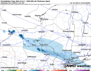
Tuesday it gets much colder as below freezing air sweeps back into Upstate NY, not just during the night but during the daytime as well. Then the next system to enter Upstate NY moves in on Wednesday. Since we are in Day 7 at this time, I don’t want to give too many specifics on this particular system, other that to say it is a snow event at this time. It will in all likelihood be a minor event.
THANK YOU FOR YOUR CONTINUED SUPPORT OF UPSTATE SNOW! PLEASE LIKE AND SHARE OUR PAGE! PLEASE THANK OUR SPONSORS FOR THEIR CONTINUED SUPPORT OF SNOWMOBILING!
Zack and Rich Lupia
Upstate Snow
January 30, 2025
Please thank our advertisers on Upstate Snow for 2024-25
Banner Sponsorship
Great Lakes Equipment
Enjem’s Flooring America
Ohio Ridge Riders
ilsnow.com
Southern Tug Hill Sno-Riders
Saratoga Snowmobile Association
Business Sponsorship
Wedge Life
Paton & Son Excavating and Landscaping
Personal Sponsorship
Jim and Colleen Andre


