Good morning again Upstate Snow Nation! So what the heck happened yesterday to me?
My system went down. It was down for at least several hours if not more than 1/2 day. If you were looking for information during this time I am very sorry to have upset you. Once service was restored yesterday afternoon, I needed time to be able to update the site, especially considering the big storm and big changes that are coming to the region tonight and into this weekend. Get ready! It’s gonna be FUN..
And thanks again for your extra dose of patience with me over the last week. I don’t mean to be like this in mid-season. Not at all.
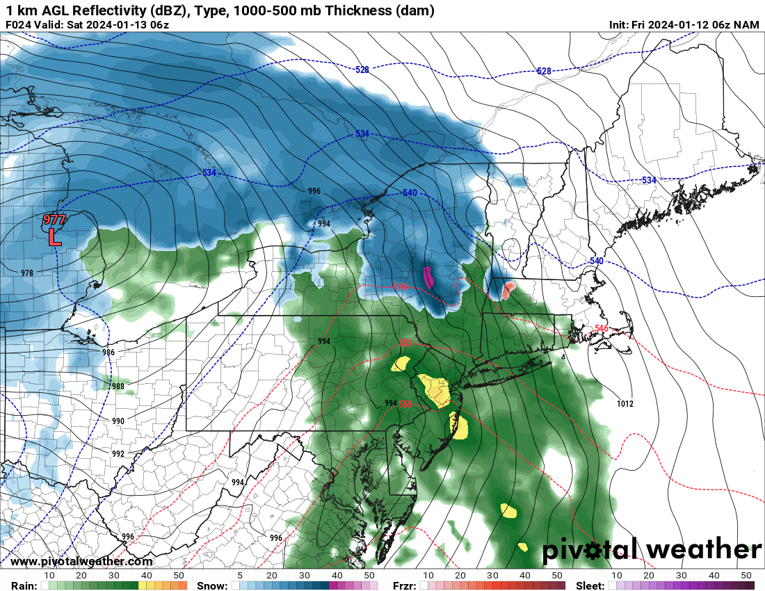
Strong storm system will approach the area again today. What’s now a 996 low over the Mississippi River will become a 978 low by tonight just west of Detroit. Once again, we are dealing with at or near bombocyclogenesis levels here. This is the reason wind advisories are in effect for pretty much the entire state. High Wind Warnings downwind of Lakes Erie and Ontario for more damaging winds in excess of 60 MPH are expected. So what about precipitation? It starts off a a mix of snow and rain, but later tonight as the low bombs out to our west and the southeast winds get fierce, it changes to rain.
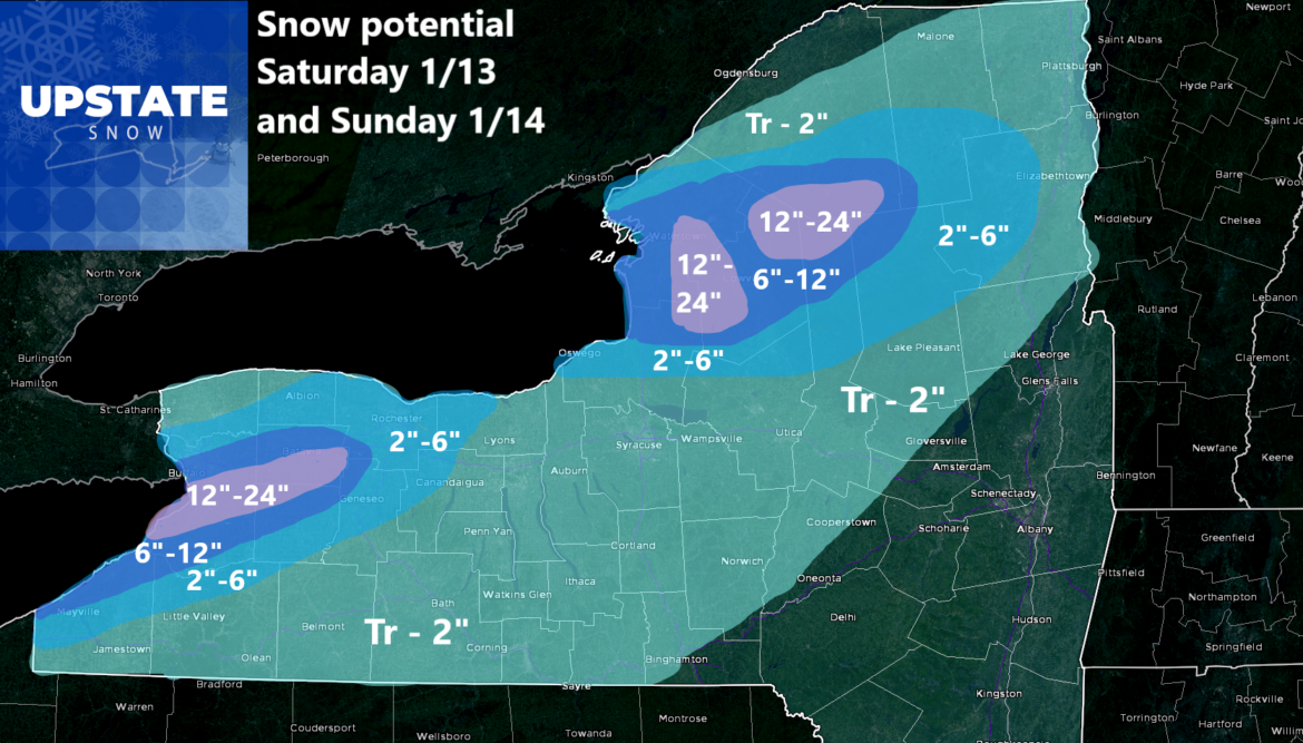
Saturday morning our arctic cold front comes crashing through the state. This will mean a temporary break in the winds. That is until the WSW winds get roaring later in the day on Saturday from west to east, reaching Central NY and areas east of Lake Ontario Saturday afternoon. During the day, highs will be in the morning, especially in Central and Western NY. Then temperatures fall in the afternoon as the west to southwest winds get roaring. Rain changes to snow. Most areas of Upstate NY should see a trace to an inch or two of snow out of this on Saturday and/or Sunday.
But the areas of Lake Effect… That will be… A much different story…
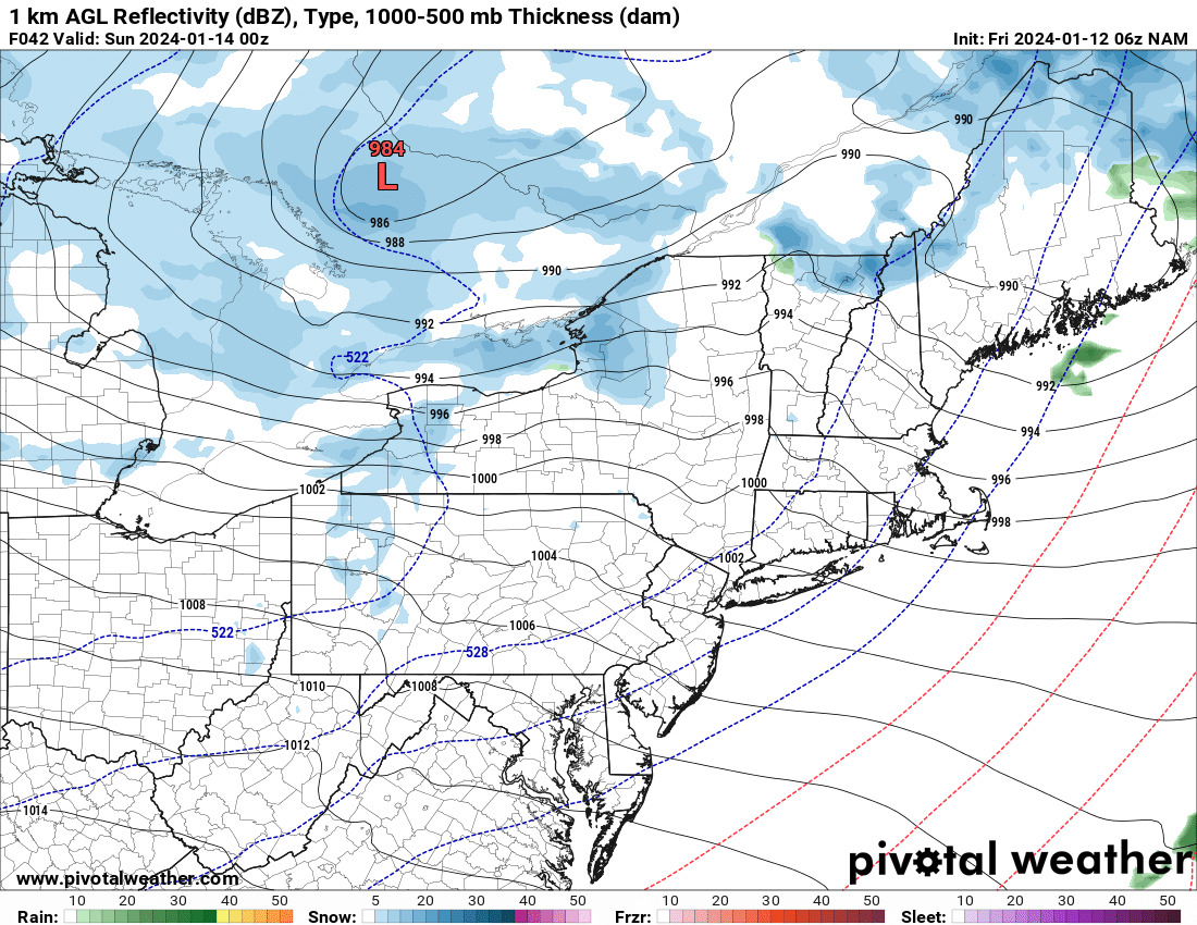
The warnings are not up for this yet and won’t be until later today. When they do come out, please heed them. This lake effect event with +4 to +6 lake water temperatures, steamy for January, and air temperatures at 850 ranging -13 to -17, will make this a moderate to an extreme lake effect event. This lake effect event will last well beyond Sunday as well. I’m just counting on the first 36-48 hours of this event here.
Winds shall be WSW. General direction off Lake Erie should be 250, which will just miss Downtown Buffalo and points north to the Tonowanda’s, but south of Downtown Buffalo of West Seneca, East Aurora, Hamburg, and to the biggest place of them all: ORCHARD PARK. This is the bullseye zone. With the Steelers and Bills playing in the NFL Playoffs Sunday Afternoon at 1 PM, this is going to be one hell of an adventure for the Bills Mafia. 70,000 screaming fans with inches of heavy lake effect snow expected to fall around and during the game. It’s going to be insane. It could be a game for the record books. We shall see.
Off of Lake Ontario, late Saturday through Sunday night shall be prime time here. With heavy lake effect squalls from a 260/270 to a 240/250 direction, it looks like the northern 1/2 of the hill gets it way worse than the southern 1/2 of the hill. The snow bands here will be moderate to heavy as well, with up to a few feet of accumulations in 36 hours. And with a lot more cold expected from MLK Day going through next week, expect big snows up here for next week.
Again I talked a lot more about Buffalo because of the playoff game there on Sunday. Just beware the heavy lake effect snows will be downwind of the lakes this weekend, especially Saturday PM through all day Sunday.
We have spent so much time looking at the short term, I have not even told you about the longer term: Tuesday and Wednesday. The potential Nor’easter then. There is still a lot up for debate about this. The storm that would cause that Nor’easter to form has not yet entered the US, so figuring this out is a lot more difficult. Once it gets onshore and moves into the western US over the weekend and into MLK Day, I will be able to give much better details on it. You want a 1-2 feet forecast? You’ve got it! You want a NO SNOW forecast? You’ve got that too! Seriously there is a lot of debate on this one. Better to plan on this NOT happening at this time, especially with us being within 7 days now.
And it stays cold for awhile longer. Wow man I never thought I would see this in the middle of winter being how mild it had been but it is so refreshing and so much fun to see! So the bottom line is this: GET READY TO RIDE! WHEREVER YOU CAN. WHENEVER YOU CAN.
Period. End of story. Enjoy!
Rich Lupia
Upstate Snow


