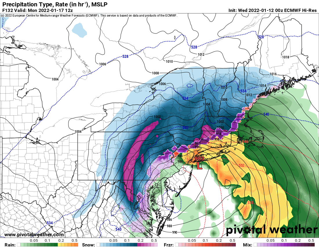
Well that changed fast! 24 hours ago both long range models shot the monster Nor’easter for Sunday and MLK Day (Monday) off the coast and was ready to bomb Nova Scotia with a Category 2 hurricane, like 964 mb! Shortly after yesterday’s blog was posted, the 12Z run came down and everything changed. All of the sudden the hinted possibility of a southeastern US snowstorm started moving the needle towards LIKELY. And the storm, instead of going out to sea, would come up the coast to the Northeast.
There are GREAT differences within the GFS and the Euro. This scenario, which is still day 5-6 at the moment, is by no means set in stone. But the odds are increasing for an MLK Day storm across the Northeast, that just like last year, could send the snowmobile season from eh, to AWESOME in a flipping hurry.
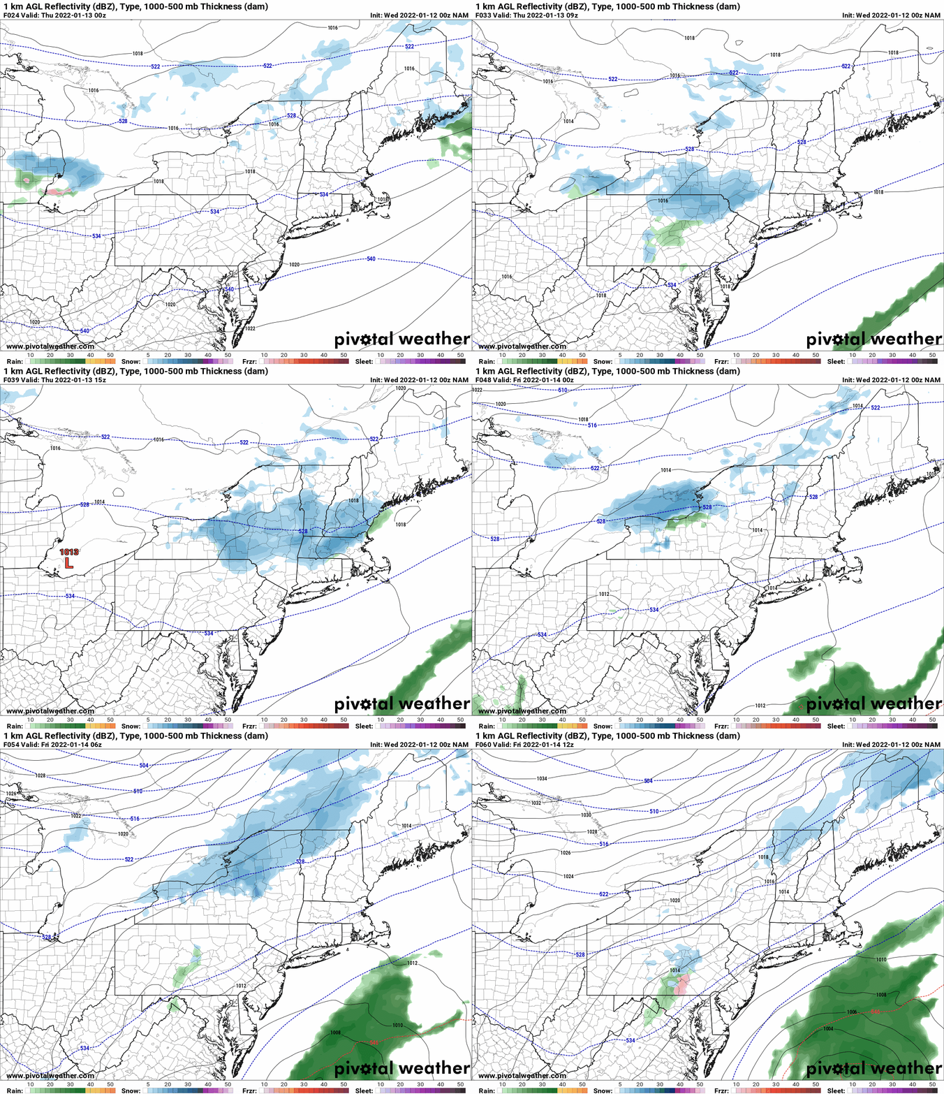
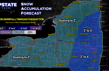
But first, the here and now. It’s still bitter cold this morning but this arctic blast is about to run out of gas. Temperatures this afternoon will shoot skyward, and hit if not break freezing today for lower elevation locations across Upstate NY. Adirondacks and Tug Hill, especially areas with deeper snowpack from the recent lake effect snow should stay in the 20s today. Overnight tonight and tomorrow morning our next system drops into the area and gives us some light snow. This will be dusting to an inch or two stuff, not worthy of a map. Thursday night into Friday morning, with the front lingering overhead, another weak wave goes by with more light snow, another dusting to an inch or two. But this second wave, also give the high sign for the arctic front to head south again. This time, it’s a north to northeast wind that kicks in Friday, holding temps steady if not dropping them during the day.
This is the beginning of the setup for the possible MLK day storm.
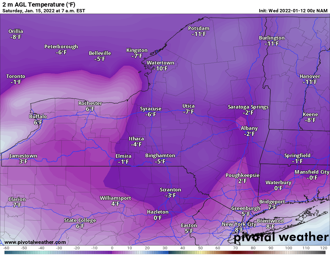
Saturday gets BITTER COLD. Same level as what we just went through yesterday. If not, maybe a few degrees worse? Plan on freezing your butt off to start the weekend. If you choose to go out and ride Friday PM or anytime Saturday, BUNDLE UP! At least these conditions are continuing to stop the water from running underneath, freezing things down and making ice on the lakes for snowmobile connections.
Sunday is when things start to come together with our approaching storm. The question is: how will it approach? Will it be snow, or will a mix play into this somewhere at some point? To answer those questions, we need to go back to the whole path of the storm. To do that, lets head to the Saskatchewan Screamer!
What the hell is that anyway? There is a rule in meteorology where systems diving into the Great Lakes and Northeast out of Canada, will have an impact. Most of the time, by far, 3/4 of the time, these systems we refer to as “Alberta Clippers”. These systems come across the US/Canadian border near Alberta, then rocket their way across the northern US, through the Great Lakes and into the Northeastern US. These systems are dry, coming over the Canadian Rockies, but have a lot of “spin” with them. It’s that “spin” that squeezes out the few inches of snow here and there. Most of the time that’s all these “clippers” thrown down as they race through on fast jet stream winds. So if 3/4 of the systems are Alberta Clippers, what about the rest? Well, this is where out Saskatchewan Screamer comes in. These systems, about 3/4 of the 1/4 of the systems left (approximately 20% of the systems), cross the US/Canadian border in Saskatchewan, usually coming across in North Dakota. This is key because these systems have even more spin than Alberta Clippers, tend to be stronger, and dive more southeasterly rather than east southeast. As these systems dive to the south into the warmer and more moist air, they can turn into bigger systems. This is exactly what this one is doing. It’s going to dive from North Dakota tomorrow, all the way to Louisiana on Saturday. So with all that spin in the atmosphere, going that far south, something will happen. For sure. Only question now is what and where.
Digressing for a moment, if 3/4 are Alberta Clippers, and 3/4 of the 1/4 left (around 20%%) are Saskatchewan Screamers, what’s the other 5% left? MANITOBA MAULERS. These are rare, but if they pop up, guaranteed storm. These are the strongest of all. Some of our biggest Nor’easters started off as MANITOBA MAULERS. For now, this is not the scenario. Back to the storm.
We’ve established for sure a SASKATCHEWAN SCREAMER will dive south from North Dakota to Louisiana on Saturday. That part of the forecast is nearly poured into concrete… the 72-84 hours that are so critical to me in winter weather forecasting. Nearly all models agree on this general motion. But after 84 hours? Where the hell does this thing go?
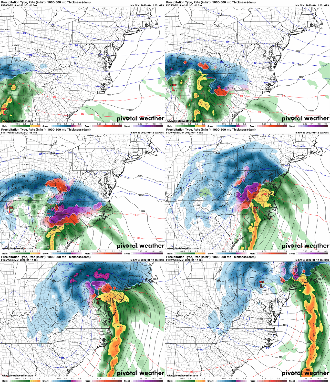
If you believe the GFS, which is notorious for losing southern stream systems, underestimating their development and strength beyond 84 hours, the storm hits northern Louisiana then makes a sharp right turn and tracks across Tennessee, then jumps a secondary low to Cape Hatteras. Then the low comes up the coast. Literally. Mix mess gets well into NY, even farther west than SYRACUSE.
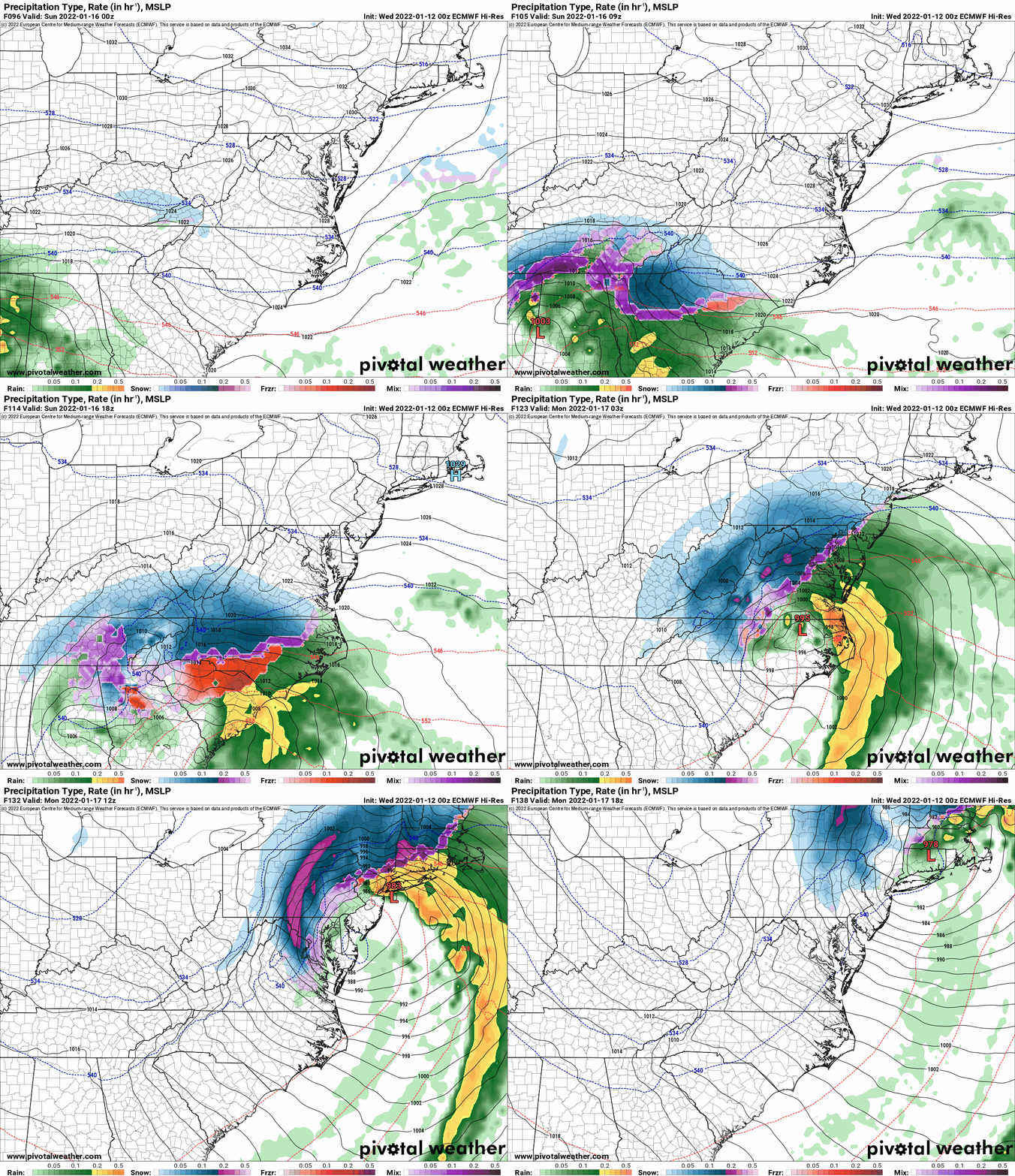
If you believe the EURO, it brings it FARTHER SOUTH. Because the southern storm is more developed and the EURO holds on to this system better, bringing a SNOWSTORM to places like Atlanta, Greenville and Charlotte, places that have not seen a snowstorm in YEARS. Then tracks it up the coast into the Northeastern US.
As always, I like the Euro scenario at the moment, but am not 100% sold on it. Yet. Tomorrow the models get the critical 84 hour window into the Southeastern US. Based upon that information, I will be able to say for sure, if Upstate NY is likely to get hit, when with a little bit more specificity, and potentially how much snow. With the low tracking inland a bit, this is a scenario for snow to mix mess for the Hudson Valley, Catskills, and potentially CNY and the Mohawk Valley, placing the heaviest snows along and west of Interstate 81. A slight shift can bring this storm farther east and bring the heaviest snows EAST of I-81. Every winter storm is different. We’ve got time. Just keep watching.
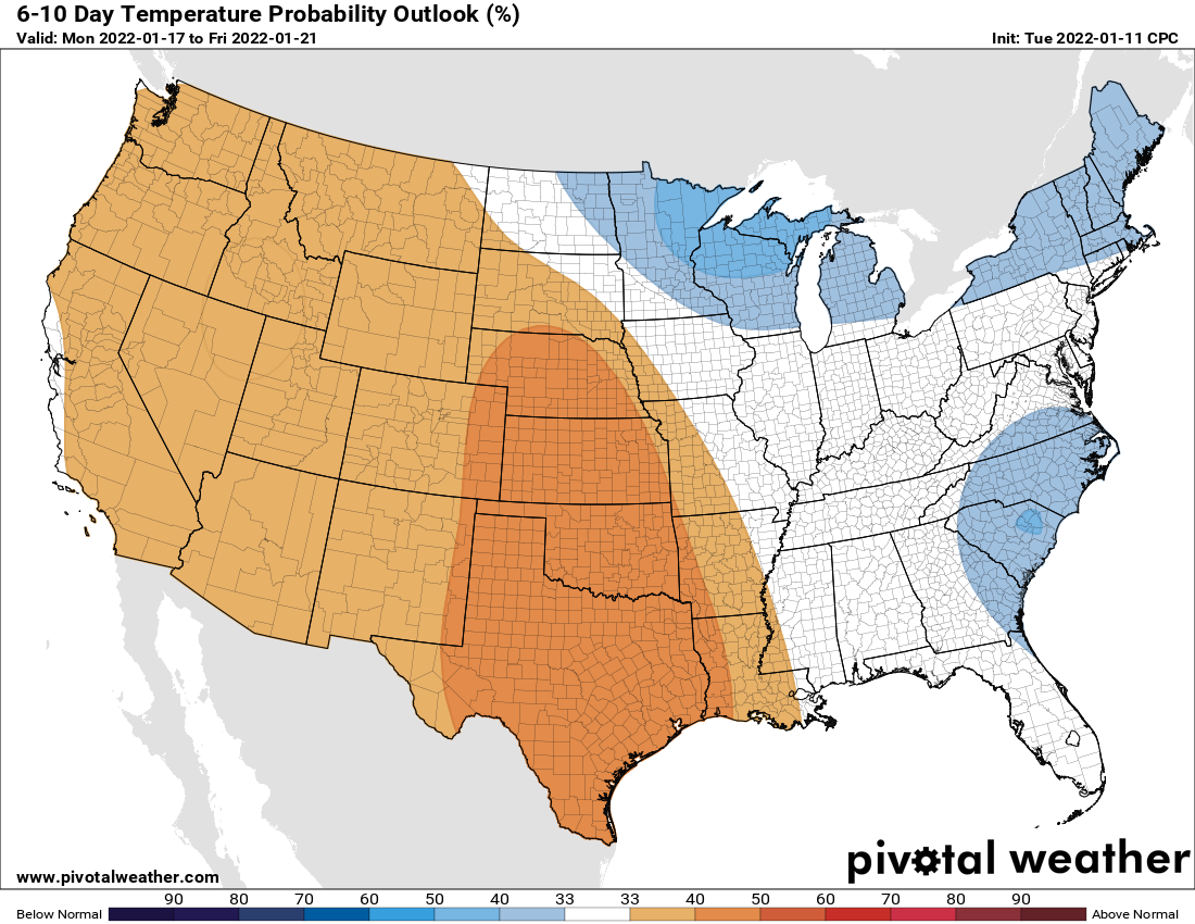
Oh, and is winter going to go away anytime soon? NOPE. 6-10 and 8-14 days paint Upstate NY squarely in the BELOW NORMAL category. So count on winter and whatever snow we get to stick around. What we have been praying for all winter! The prayers, are being answered.

THANK YOU for the folks that continue to bless Upstate Snow with membership and sponsorships including our newest business, EnergyMark LLC from Western NY! The list literally keeps growing by the day! Thank you for the blessing.
To become a MEMBER, drop me $10, and you’ll get name recognition, or if you wish not to use your name, recognition to your favorite snowmobile club or where you live. To become a SPONSOR, drop me $60 and I’ll put up a link to your business, Facebook page or snowmobile club!
Click below to get started
paypal.me/lupiallc
www.venmo.com/u/Richard-Lupia
THANK YOU to our faithful sponsors and members!
SPONSORS
Southern Tug Hill SnoRiders
Saratoga Snowmobile Association
Ohio Ridge Riders
ILSNOW.com
Enjem’s Flooring America
Water’s Edge Inn – Old Forge
Adirondacks Speculator Chamber of Commerce
White Lake Inn
Toads LLC Fisher and Snow Dog Plows, Cairo, NY
John Schoff Memorial Vintage Ride – January 15, 2022
Lincoln Mountain Gansevoort Snowmobile Club
ATV Tractor
Foley’s Lawn Care and Gardening
Better Homes and Gardens Pristine Real Estate – Cape Coral, FL
North Country Market – Thendara, NY
PR Plus Small Engine Repair – Sherrill, NY
EnergyMark LLC
MEMBERS
Chris Rinck
Charles Klesse
Chaz Albertson
Dave Gleasman
John Bates
Darrin Harr
Mark Enjem
Matthew Pistner
Eric Vilovchik
Brian & Paula Bedell
Robert G. Gartley
Chris Higgins
Nathan DeMarco
Frank Presky
Chris Schoff
Richard Keller
Mark Spano
Paul Marconi
Michael Schrader
Chris Skipper
Frank Sansone
Mercy Board LLC
John Scalora
Tom & Alis Vincent
Angelina Gogola
Cricket Corelli
Russ Lamoy
Jeff Greene
Chaz Albertson Jr.
John Bossolt
John Foley
Andy Artessa
Jenny & Ron Tyre
Mark Finkbiner
Christopher Cawley
Darren Bryant
M&M, SnoChic and SnoL!fe
Doug Wasiura
Devon Senecal
Billy & Millie McLaughlin
Rachelle Gross
Marc Mellaly
DV
Vicki Muehleck
Gertude Corelli
Brian Shoemaker
Brian Salamone
Tom Sylvia
Tom Robinson
Eric Olofson
Gill Benedek
Ron Linich
Debra Hubbard
Dennia Sullivan
JAYSOS!

