Holy cow! The generational event (once every decade to several decades) hit Central New York, especially the Utica/Rome area WITH AUTHORITY! And there is more yet to come! So far…
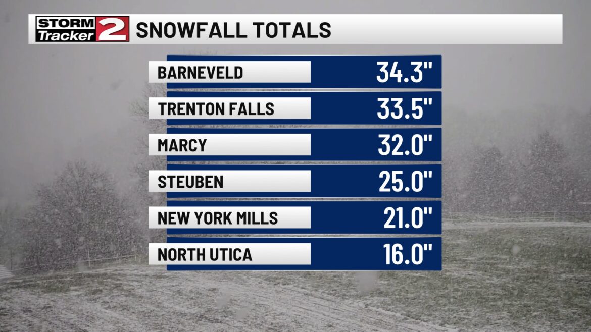
That was just as of 3 PM Friday afternoon. There were more reports and higher reports that came in after that. It wasn’t until sometime last night that band dropped south and is hitting the Syracuse area into the Binghamton area and even into Northern PA early this morning. So what happens when the wind shifts during the day today?
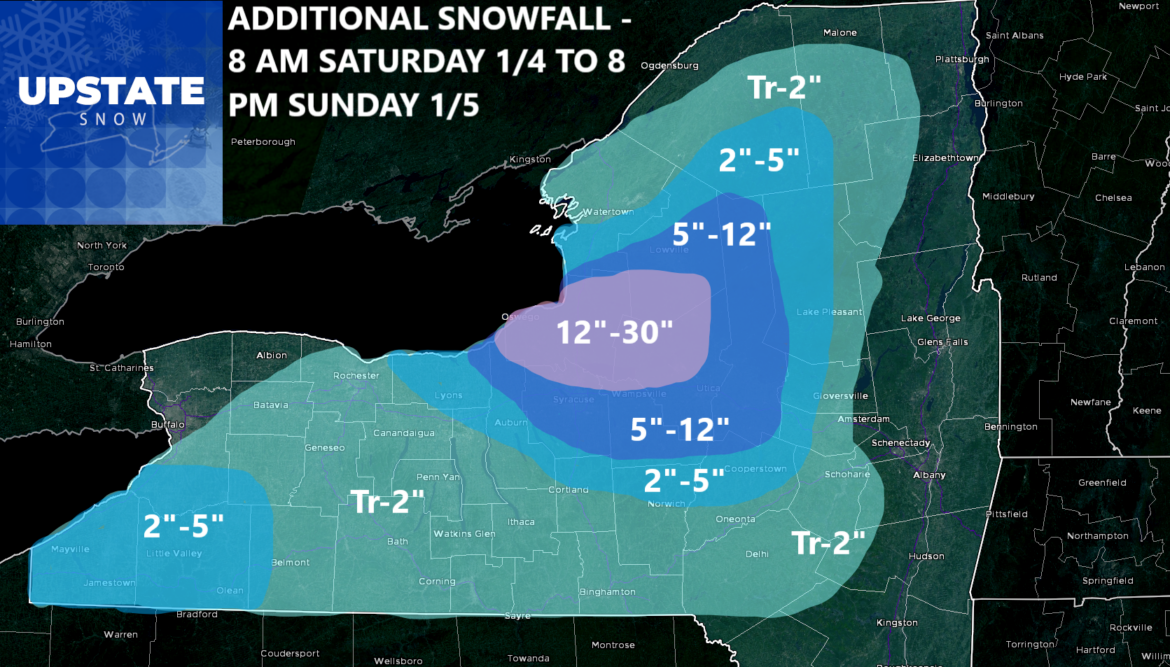
This. The winds shift back to a 280 to 290 direction. This should keep the heaviest snows just north of the NYS Thruway. Areas north and west of Utica up into the Southern Tug Hill and Oswego County still have another few feet of snow to go before tomorrow night. Other areas surrounding it drop off quickly. Here is what the models are showing as of now:
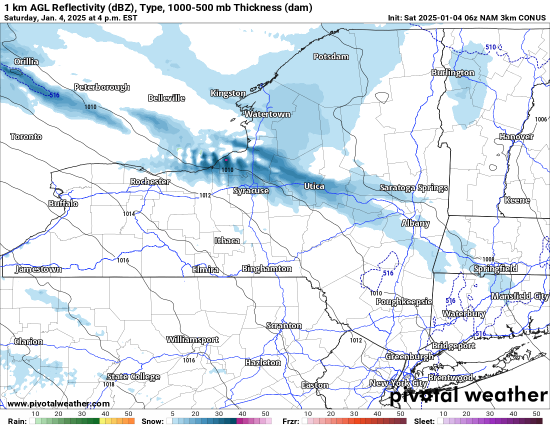
The snow returns to the north this afternoon and into this evening. It becomes heavy this evening with 1 to 2 inch per hour. Tonight should be the heaviest snow with whiteout conditions at times north of Syracuse, from the Utica/Rome area and points north into the southern parts of the Tug Hill, however, central and northern parts of the Tug Hill will miss out on most of the heavy snows this time.
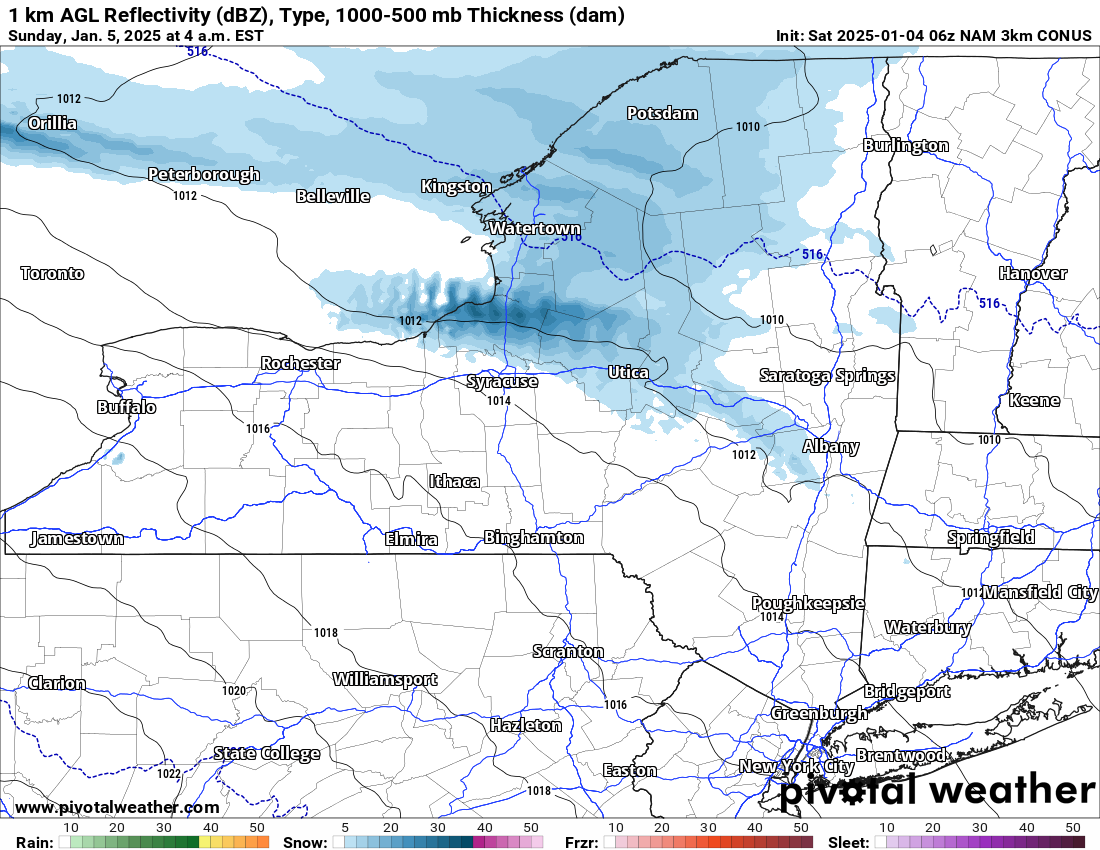
Sunday morning the snow is continuing heavy at times in that 280 direction. That keeps it over Oswego County into northern Oneida County, central Herkimer County and into Fulton County. At least the heaviest snows with the whiteout conditions at times. If you are thinking of church Sunday Morning in these areas getting hit, you may want to reconsider.

By Sunday evening, the snows begin to finally die down as the winds shift more towards the north and west, giving one last spritz of a dusting to an inch or two. Then finally, after five days, the lake effect finally STOPS!
GENERATIONAL EVENT
Folks, this storm will go down in the Utica/Rome area, Mohawk Valley and the western Capital Region as a generational lake effect snow storm. This type of storm we have just seen and will see through tomorrow night only occurs once every few decades. 2007 was the last time we had lake effect like this. Before this was 1993, 1977 and the Blizzard of 1966.
Thank you for hanging around with me and for your understanding. The fact the area of Upstate NY I cover the most, got hit the most and in some cases, the most ever just strictly from lake effect, was amazing. It is an honor to be with you!
Zack and Rich Lupia
Upstate Snow
January 4, 2025
Please thank our advertisers on Upstate Snow for 2024-25
Banner Sponsorship
Great Lakes Equipment
Enjem’s Flooring America
Ohio Ridge Riders
ilsnow.com
Southern Tug Hill Sno-Riders
Saratoga Snowmobile Association
Business Sponsorship
Wedge Life
Paton & Son Excavating and Landscaping
Personal Sponsorship
Jim and Colleen Andre
Chris Schoff Memorial Vintage Ride – January 11, 2025


