
It’s time to write another blog. So here I go. Deep snow cover continues across Central NY, The Tug Hill, Adirondacks and North Country. Some areas have all time record high snowfall on the ground, especially Oswego, Oneida, Lewis and Herkimer Counties. There will be some melting of the snow next week, but not a whole lot of it before cold and snow return in time for March.
Hey! There will not be a whole lot of snow to talk about over the next week. Seriously there will not be. A few inches here, an inch there, and some rain over here. It’s a short term pattern change that we have FINALLY received after being BURIED up here! So many roof collapses, other places closed out of caution, others being dug out as quick as possible.

At least the weather will be helping! Somewhat. Again, not much going on here. Some snow continues off of NW winds off of Lake Ontario and whatever breaks are left in Lake Erie. A few inches are expected. In a few counties, it increased to a winter weather advisory. Based on how this year is going I would be careful with that!
Saturday is dry and partly sunny with highs reaching the 20s with lower elevation locations actually approaching freezing. Amazing! Then after sunset Saturday, the next clipper moves in. This one is brief.
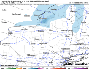
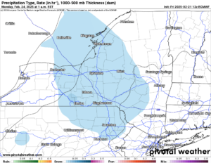
Some light lake effect is possible Saturday Night through part of Sunday. Mainly over the Tug Hill but with less across the Adirondacks and North Country. Another weak wave moves in Sunday Night and into early Monday Morning.
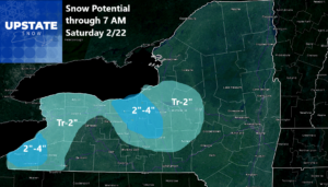
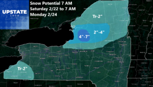
Here is how the snowfall forecast is looking this weekend. Again it’s NOTHING for a lot of the state. For some parts of the state maybe a few inches. Best chance is over Tug Hill.
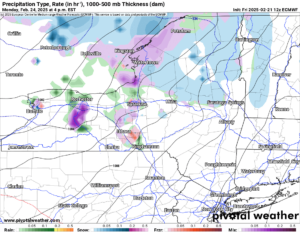
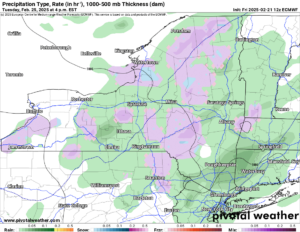
Monday the next storm system moves in. We have several of these things lined up, one after the other. Later Monday Afternoon and Evening, snow showers stay north of the Thruway. From the Thruway and south, a mix of rain and snow will be expected. This will continue into Tuesday with it getting warm enough to keep any snow or mixed precipitation to the higher elevations. The lower elevations shall turn to a cold rain. YUK!
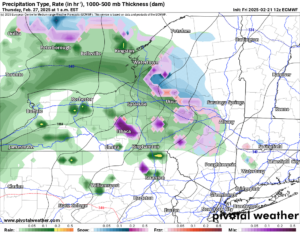
We catch another brief break on Wednesday. A brief one. Temperatures are above freezing during the day and not much below it at night. Conditions definitely by this point on the snowmobile trails will be changing. Then the next system works in on Thursday. This one is looking like rain, especially in the lower elevations.
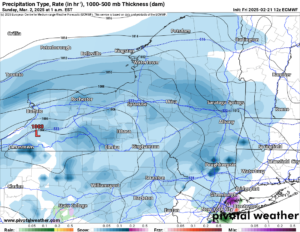
Remember the bigger snow event I showed you on my last blog? Well that is now delayed basically until next weekend. March 1-2. Still just over a week out. Still a maybe or maybe not scenario. I honestly don’t know at this point other than to say “heads up” for not this weekend but next weekend.
Well that’s all I have for now. Have a great weekend. And thank you so much for your support!
Zack and Rich Lupia
Upstate Snow
February 21, 2025
Please thank our advertisers on Upstate Snow for 2024-25
Banner Sponsorship
Great Lakes Equipment
Enjem’s Flooring America
Ohio Ridge Riders
ilsnow.com
Southern Tug Hill Sno-Riders
Saratoga Snowmobile Association
Business Sponsorship
Wedge Life
Paton & Son Excavating and Landscaping
Personal Sponsorship
Jim and Colleen Andre


