
Power outages. Lots of them. High winds. 60 MPH gusts, if not higher. Heavy lake effect snows downwind of Lake Erie (mostly frozen) but especially downwind of Lake Ontario (unfrozen). That is the way it looks for the next two days. Wednesday is a break day. Thursday is another snow day, this one mainly for areas in southern and eastern Upstate NY. Then actually, A BREAK.
Welcome! Glad we made it through the snow, sleet, freezing rain and rain. The freezing rain was intense with up to 1/2 of ice in some areas. Power outages already. Holy cow! And we are just getting started with the high winds. I also hate to sy it but with the high winds and consistent lake effect… I must mention this… NEAR BLIZZARD CONDITIONS! 🙁

POWER OUTAGE MAP
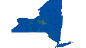
Here is the latest power outage map as of 7 PM Sunday Night. I am sure it will be a lot worse tomorrow. We are at over 11,000 people without power, a majority of them in Central NY.
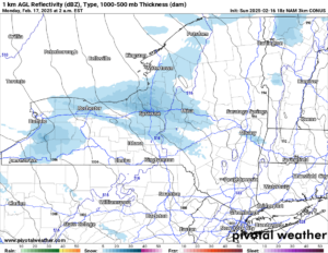
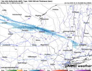
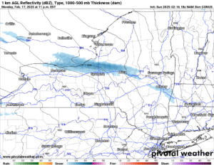
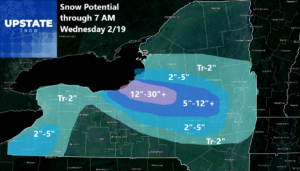
Here are the bands of heavy lake effect snow. By far the heaviest off of Lake Ontario with near blizzard to blizzard conditions! Snowfall accumulations will also pile up quickly. In some areas, it will be measured not in inches but in more like feet! The snow is heavy this evening, tapers some overnight and early tomorrow, then gets going big time later tomorrow, tomorrow night before gradually calming down on Tuesday. Here are the snowfall numbers for it:
SNOWFALL MAP
Then as we get to Wednesday, it is a very cold day but it is QUIET! This is definitely the day to DIG OUT! If you are falling behind and you need help to shovel or dig someone out of all this snowfall and all this mess, Wednesday is your day. But this is for ONE DAY ONLY at participating locations. Void where prohibited!!! Because the next storm rolls in Thursday.
The snowfall come up from the south and east. It has been this way for several days. It was absolutely clear that from the NYC area and points south are going to get CRUSHED by this storm. Now some uncertainty has come into this as this storm is now looking to shoot straight off the coast, rather than ride up it. If I had to give an idea right now I would say a few inches at best for some, ZERO for others. We are about 24-36 hours before this storm reaches inside 84 hours, within our high resolution models, where we can give somewhat of a decent call on snow totals.
From model to model run as we have gotten closer there has been some variance to it. For a few runs it was borderline historic. Now it’s just another snowfall. And it’s fading each model run as we get closer. At least for Upstate NY it is.
THE LONGER RANGE
6-10 Day

8-14 Day

3-4 Week

Well it’s a good old fashioned winter. It truly has been. Way below normal this week. A brief reprieve next week with temperatures back near normal, then heading into March, the thermometer heads back down. Again. Wow!
We have definitely seen a better winter than 2018-19 and 2017-18. This is at the level of 2014-15, one of the coldest and snowier winters we have experienced over the last 30 to 50 years. Only a few winters like 2003-04, 2002-03, 1995-96, 1993-94 then going into the 1970’s rank in these terms. When this winter is done in the spring and we look back over the tallies for everything, if it is not a TOP 10 winter for snowfall, it will likely end up in the TOP 20 of the last 100 years. At the rate we are racking it up, especially in Central NY, the Tug Hill and the Adirondacks, it could be deep into April before the snow finally melts, and into May before all ice is gone.
ENJOY YOUR WEEK! BE SAFE! DON’T GO CRAZY WITH THE POWER OUTAGES.
Zack and Rich Lupia
Upstate Snow
February 16, 2025
Please thank our advertisers on Upstate Snow for 2024-25
Banner Sponsorship
Great Lakes Equipment
Enjem’s Flooring America
Ohio Ridge Riders
ilsnow.com
Southern Tug Hill Sno-Riders
Saratoga Snowmobile Association
Business Sponsorship
Wedge Life
Paton & Son Excavating and Landscaping
Personal Sponsorship
Jim and Colleen Andre


