
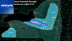
Lake effect snows will hit tonight and tomorrow for Valentine’s Day. They give out by tomorrow night. Ready for a rest? FUGEDABOUDIT! Steady snows with several inches across all of Upstate NY move in Saturday, particularly in the afternoon and Saturday Night. Sunday is a wildcard. Could be a continuation of heavy snows with a foot or more in the best areas. Sleet/freezing rain and/or rain move in Sunday, but how far and how much??? Once this storm moves out later Sunday… BAM! A serious cold blast comes in with more heavy lake effect snow for days afterwards. WHEN DOES IT END???
Well it will end. At some point. It may take several more weeks for it too, but it will end eventually. For many years just getting one storm was a big deal. LIKE LAST YEAR! But in a winter like this, the worst in a decade, we get pounded, then pounded again, then pounded AGAIN! So many things to sort out. Let’s take this one thing at a time:

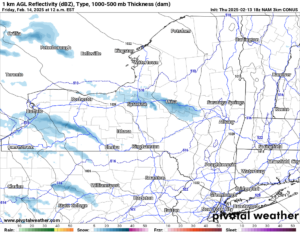
LAKE EFFECT SNOW WARNINGS THROUGH TOMORROW NIGHT
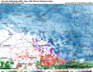
The lake effect snow will wind up in a hurry. It will be mainly on a 290 to 300 wind field. This favors areas east of Rochester like Wayne County, Oswego County, northern Cayuga County, Onondaga County, Madison, Oneida and Herkimer Counties. These areas in general will be under fire for the most snow. Several inches will come in a short time. The heaviest bands will be narrow so not everyone will get the same amount. This band of snow gets going quickly tonight (may already be going when you read this post) and continuing through the day on Valentine’s Day, especially during the day. Give yourself plenty of extra time when dealing with this lake effect snow. And this isn’t the only area to talk about. Even though Lake Erie is basically frozen over, the lower levels are about saturated, so any rise in the elevation off of the Lake will generate snow. That’s what will happen in Chautauqua, Cattaraugus and southern Erie Counties (the south towns of Buffalo). Several inches of snow are possible here too. After all that is said, here is my updated forecast:
SATURDAY
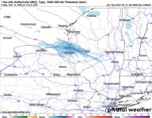
After a brief break in the snows Friday Night and into Saturday Morning, that is when the snow will reorganize quickly and get heading out over all of Upstate NY as a good storm system deepens to our south and west. Expect steady snows over Upstate NY during Saturday Afternoon and Saturday Night. Generally looking at about 1/2 inch per hour on the snows but would not be surprised if some areas get up to 1″ per hour.
SATURDAY NIGHT
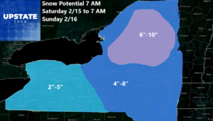
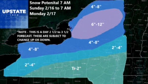
This is where out low pressure approaches the state, warmer air starts mixing in especially aloft, and snow starts to go to at least sleet, if not freezing rain. The best chance of this is along and south of the NYS Thruway. North of the Thruway should stay mainly snow and you will see healthy snow totals from this storm as a result of that! Here is our map for Saturday 2/15 into Sunday Morning 2/16
SUNDAY
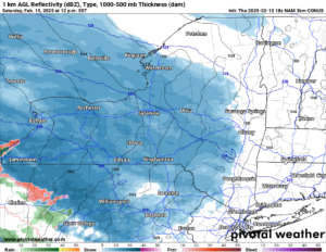
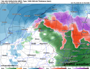
This is where our sub 990 low comes by Upstate NY. Previously it was shown as far north as Syracuse, changing it to all rain over a good part of the state except the Adirondacks and North Country. It has not changed much from that and if anything, it has delayed that low passing by from late morning to sometime in the afternoon. It’s about a 4-6 hour delay as this is coming in line into our short term higher resolution models. I would expect snow to continue to hit north of the Thruway, which is also north of the low. Along and south of the Thruway, which is along and south of where this deep low pressure will be, that means sleet and freezing rain change to rain for a time, and turn everything into a mix/mess! Again!
SUNDAY NIGHT
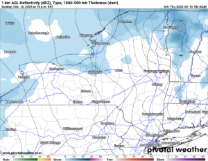
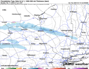
The deep low moves east into New England, the winds come around to the northwest, and yet another FLASH FREEZE takes place just like what is taking place now tonight in the same areas. Any precipitation changes to snow, and we get a minor accumulation before it switches to more of a lake effect band of snow. That’s for President’s Day and for Tuesday as well. In the meantime, since it is at the edge of my range, the forecast for snow, sleet, freezing rain on Sunday and Sunday Night across Upstate NY.
PRESIDENT’S DAY & TUESDAY
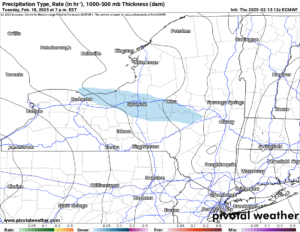
Snow, heavy at times develops once again in the same 280 to 300 window, putting the more populated areas of Utica/Rome, Syracuse, Oswego, Auburn and into the towns between Syracuse and Rochester more into the bullseye. Again. Since this is beyond my 84 hours at this point, I will not detail a specific map for this. All I know is this: Several more inches of snow is at least possible to likely, in the same areas getting hit tonight and Valentine’s Day (tomorrow).
NEXT WEEK
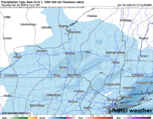
After we get through the lake effect, everyone in Upstate NY will be shaking in the COLD. The BITTER COLD! Temperatures will be single digits and teens. Lows will be from the single digits in the lower elevations to BELOW ZERO in the rural areas and the higher elevations. For several days. The last map is for Thursday next week, one week from today, with another general snowfall moving through Upstate NY. Again!
Not saying this hasn’t happened before. Just reminding you cold and snow like this has not been around for a long time. And it doesn’t seem like it will end anytime soon either. I am waiting on the new 3-4 weeks and the new monthly outlooks tomorrow or over the weekend. I am just saying to you right now: it is not looking good my friend. Definitely not looking good.
Just enjoy the winter you have wanted for years, could not have, but finally have now! RIDE RIDE RIDE!
Zack and Rich Lupia
Upstate Snow
February 13, 2025
Please thank our advertisers on Upstate Snow for 2024-25
Banner Sponsorship
Great Lakes Equipment
Enjem’s Flooring America
Ohio Ridge Riders
ilsnow.com
Southern Tug Hill Sno-Riders
Saratoga Snowmobile Association
Business Sponsorship
Wedge Life
Paton & Son Excavating and Landscaping
Personal Sponsorship
Jim and Colleen Andre


