Welcome to the post you didn’t want to read from me. The “January” thaw… or the “February” thaw… is finally here. It will be here in general for 4 days. Temperatures will be near to above freezing the entire time. The best chance of rain and temperatures in the 30s, if not the 40s will be Wednesday Night through Thursday. After that, we resume normally cold Upstate Snow Winter Weather Operations!
The thaw of 2025 is here. At least the first one! In winters when we have so many of them you lose count of them and the snow cover is thin to “die hard” levels, to where on this date last year (or close) with hardly any snow on the ground and 80 to 90% above normal temperatures for the next 2 weeks, we hung up the season. Until we got hit badly, the worst that we had all season, in late March and early April. Yikes! Boy is this year different!

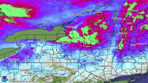
Over two feet of snow takes up many places near and especially north of the Thruway. That’s in GREEN. The PURPLE areas surrounding it that cover most of the rest of Northern NY? 1 1/2 to 2 feet on the ground. In some areas, it is RECORD snowpack on the ground. Several feet in spots! The water content? UNBELIEVEABLE! In the biggest areas, the Tug Hill and especially the southern slopes of the Tug Hill. This being Oswego County, Northern Oneida County and Central Herkimer County… we have up to 10 to 12 INCHES OR MORE TRAPPED IN THE SNOW PACK! YIKES!!!
That’s where it’s bad. Now we go to where it’s not so bad first.
The first to be taken offline, and most have been already or are about to be, are the Genesee Valley, Finger Lakes, Southern Tier and the Hudson Valley. See ya! Next up will be Western NY, areas south of the Thruway, and the Capital Region. This area will take a hit, some areas may close. Some may not. From the Thruway, northbound, from Central NY, to the Tug Hill, Adirondacks, and North Country… A brief 4 day thaw where most temperatures will be in the 30s instead of the 40s, and with near record snow pack on the ground, NO WAY! If there is anywhere that riding will continue this week, Oswego, Oneida, Herkimer, Lewis, Jefferson, St Lawrence, Franklin, Clinton, Essex, Hamilton, Fulton and Montgomery Counties have your best shot of staying open all the way. Onondaga, Cayuga, Cortland, Madison, Chenango, Otsego, Schoharie, Saratoga, Washington and Warren Counties in this will be the wild cards. Some may make it. Some may not. The rest: ASSUME CLOSED FOR NOW
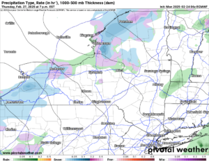
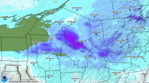
You see the warmth makes it’s greatest charge to us Wednesday PM and through Thursday (MAP 2). I believe this is the first time I have seen 550+ thickness values hit Upstate NY this year, but it looks like they will for 12-24 hours at least. This is the zone I am most worried about for potential flooding. Do I see all 5-10 inches of the water that have piled up since January 1 coming crashing on down and creating major to record flooding? NO. How much of that water does come on down remains to be seen. I don’t have an answer for you guys yet. Other than to say Ice Jam Flooding, is the most likely. These areas can spring up fast and can be the worst! Please look out for this, especially Thursday.
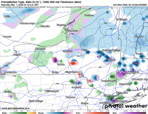
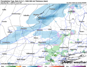
Friday we get some clearing and temperatures go back below freezing both day and night. RELIEF! Then we have more snow showers move though on Saturday and into Sunday with colder air behind that heading into the first full week of March. That is good news. At least for now. The deeper we head into March and the deeper the snowpack is heading into March, the higher and higher chances of flooding will happen. The better chances of major flooding happen too.
PLEASE KEEP CLOSE CHECK ON THINGS THIS WEEK AND HEADING THROUGH MARCH. EVEN INTO APRIL. MAJOR TO RECORD FLOODING POTENTIAL IS GROWING AND CANNOT BE IGNORED.
Zack and Rich Lupia
Upstate Snow
February 24, 2025
Please thank our advertisers on Upstate Snow for 2024-25
Banner Sponsorship
Great Lakes Equipment
Enjem’s Flooring America
Ohio Ridge Riders
ilsnow.com
Southern Tug Hill Sno-Riders
Saratoga Snowmobile Association
Business Sponsorship
Wedge Life
Paton & Son Excavating and Landscaping
Personal Sponsorship
Jim and Colleen Andre


