OK Folks things are getting clearer as we approach our Wednesday PM to Thursday AM Nor’easter… and biggest storm of the season so far. Winter storm watches and warnings being put out unusually far in advance to the south of Upstate NY from Scranton down through the central Appalachians. It’s no longer an issue of if, but when, where and how much.
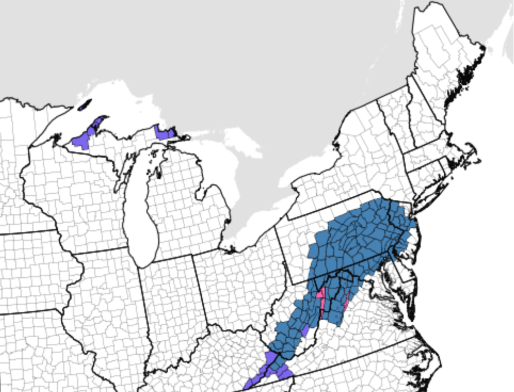
As I have said all along storm #1 sets up storm #2. Storm #1 is what is bringing snow and mixed precipitation to PA, Downstate NY and southern New England. Those areas locally could see several inches by this evening as the storm races off the coast. In Upstate NY snow showers with anywhere from a dusting to an inch is expected, and as NW winds kick in behind the storm to bring in the cold air in advance of the bigger storm… brief lake response and upslope flow could squeeze out another inch or two over the Tug Hill, along Route 20 S of the Thruway, and in the hills S of Buffalo. Not enough to warrant a snow map and I won’t so as to not add additional confusion.
Tuesday will be a breezy and chilly day across Upstate NY with temps hard pressed to get above freezing and overnight lows getting cold. The airmass is very dry as well, a true Canadian airmass with dew points in the single digits. Remember this as it will be a factor in the upcoming storm as to how far NW the decent accumulations get across Upstate NY.
On Wednesday as our weak storm fades over the Ohio Valley and coastal storm takes shape running from the northern Gulf of Mexico, across Georgia and the Carolinas to near Cape Hatteras, it’s taking on the classic track of a secondary development or in Meteorology, a “Miller B” storm. With the fact the upper level storm is dynamic and taking a southern track, adding Gulf of Mexico moisture to Atlantic and Gulf Stream moisture, it will be a big and notable storm for a lot of the country no doubt.
BUT WHAT ABOUT UPSTATE NY??? The three biggest things that will determine who gets what in Upstate NY will be 1) Exact surface low storm track, 2) The upper air low at 500mb… where does it track and does that 500mb low hang back over Upstate NY, 3) How dry the arctic airmass is and how long it takes the atmosphere over Upstate NY to moisten up and allow the snow to reach the ground. This will be key to snowfall amounts, especially in the area where amounts could be big or small, from the Finger Lakes, to CNY to the southern Adirondacks and the Capital Region NORTH of Albany. Areas south of these regions in Upstate NY, the Southern Tier, Catskills and Hudson Valley S of Albany, confidence is growing of a significant snowfall event.
Before we get into the models, you’ll notice the GFS is missing here. This is intentional. GFS notoriously is bad at handling southern systems and this one is no exception. The upper air maps don’t make sense given the intensity of the storm and are an outlier to the NAM and the Euro, and their associated ensemble runs. If you are looking at the GFS today, and/or especially, looking on your useless weather apps that base their forecasts off of the GFS model, this information may come as a surprise. Don’t be. And don’t be surprised if GFS at the last minute draws back to the NAM and Euro. I believe the NAM and Euro have a better track record and their dynamics and upper air patterns are making more sense to me given historical patterns in previous winter storms. I am using these for guidance and my forecasting decisions until I’m persuaded otherwise…
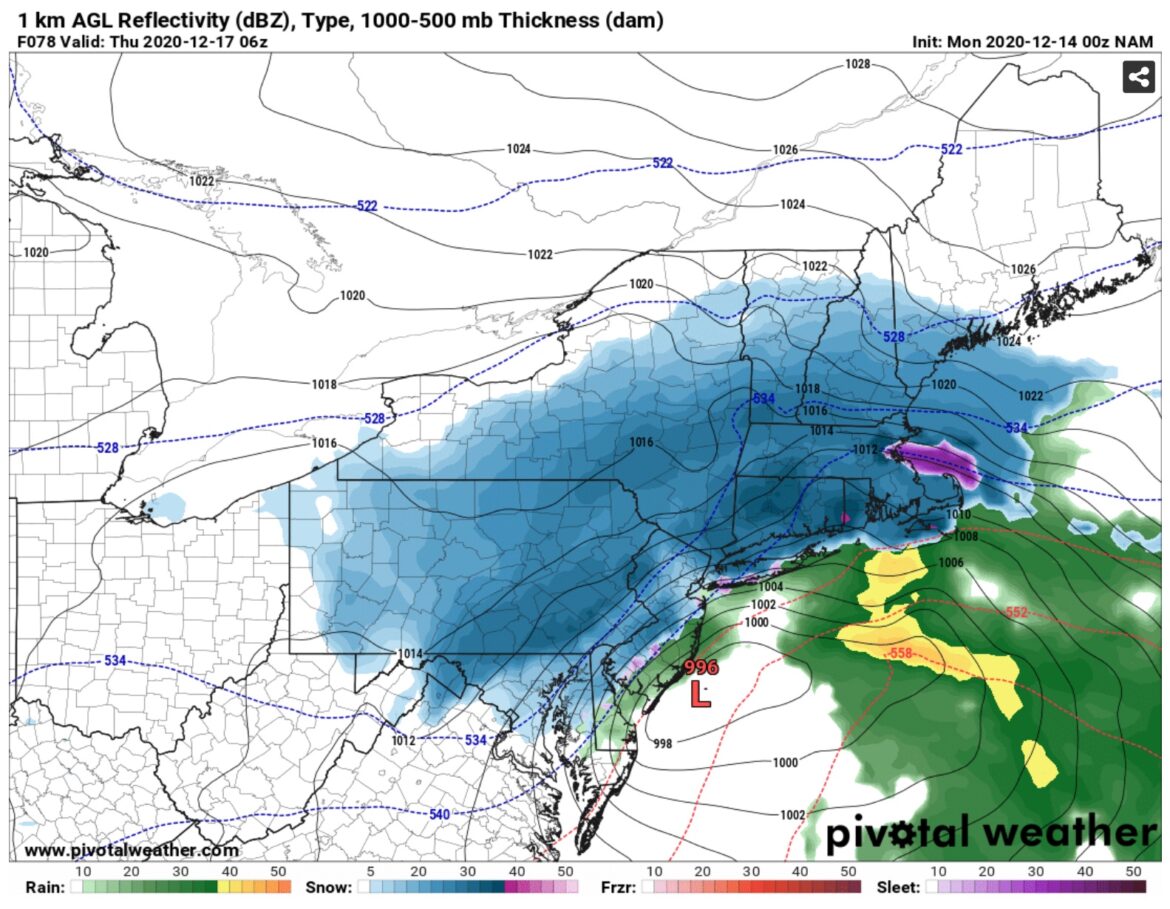
Here is the surface low late Wednesday night and projected precipitation per the NAM and Euro. NAM is by far the most aggressive for Upstate NY… And the low pressures are zeroing in on about 30 miles either side of Cape May, NJ, which is actually a better track for Upstate NY especially areas east of a Bath to Syracuse to Piseco to Schroon Lake line…
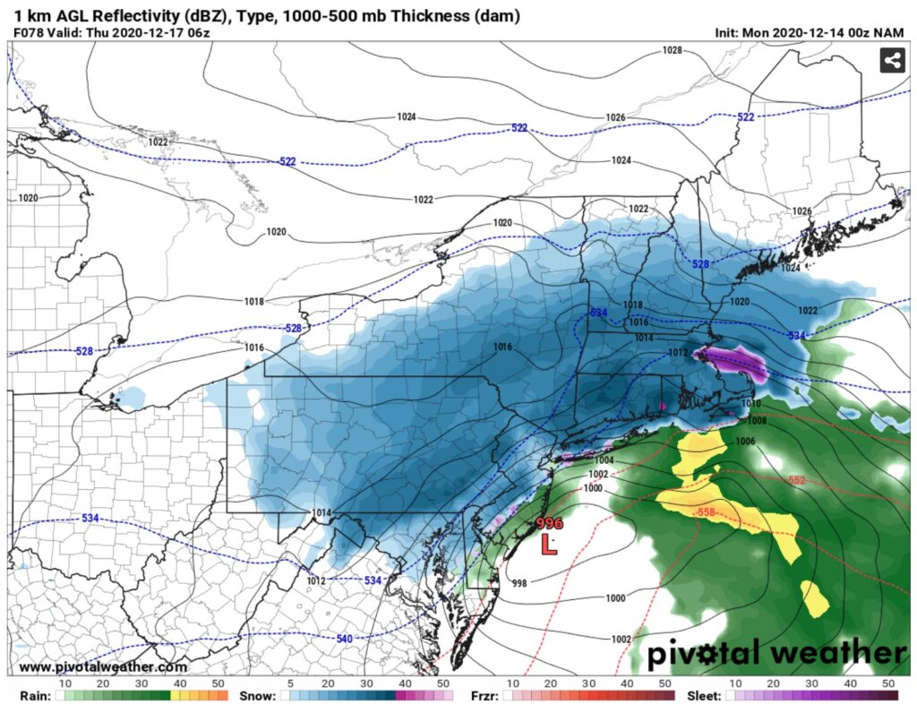
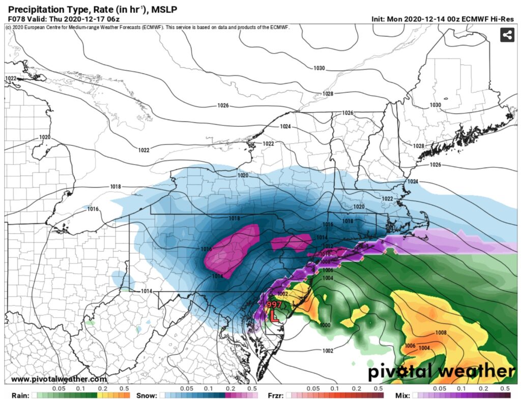
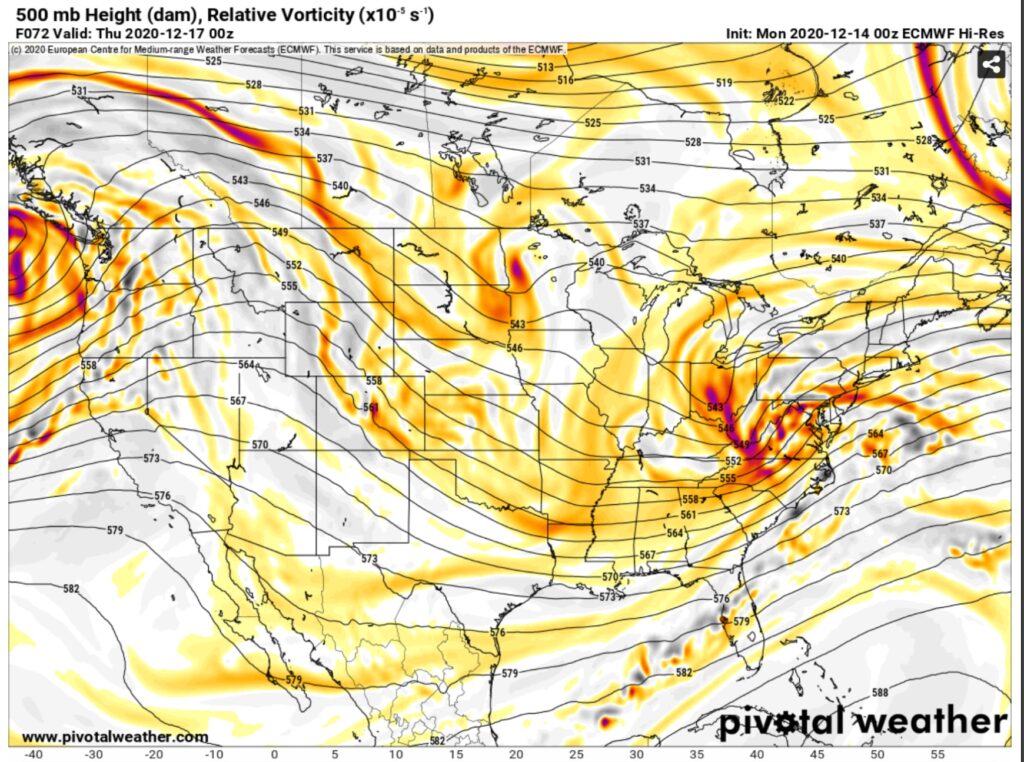
Looking at the upper level winds, historical research by the National Weather Service in Binghamton shows the best 500mb pattern for heavy snow events in their CWA (the counties they cover and warn for which includes the whole Binghamton/Elmira areas, Cortland, Ithaca, Onondaga County – Syracuse, Oneida County – Utica & Rome, Otsego County and most of the Catskills (Delaware/Sullivan Counties) + the Pocono’s and Scranton/WB, PA, the trough or dip in the jet stream as the surface low approaches needs to be centered over Ohio with a corresponding ridge over Nevada and Idaho, what I personally refer to as the “Vegas Ridge”. As you see in the corresponding upper level maps, check the box on this. Plus the trough is starting to take on a “negative tilt” which is when it’s oriented more NW to SE like this \, instead of neutral which is north south like | or a positive tilt oriented SW to NE which looks like / on a map. If this indeed is reality and verifies as NAM and EURO are strongly indicating, it means you’ll see more of a north and west shift of the heaviest snowfall amounts away from the I-95 corridor and closer to Upstate NY. Keep a mental note of this as the trends unfold and as the forecast changes in your area, especially if you follow us outside of Upstate NY from Virginia, MD, PA, Downstate NY, NYC, LI and southern New England…
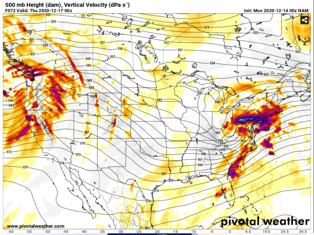
One of those “flies in the ointment” that always frustrates Meteorologists like me, is the dry air from the Arctic high, that causes “Virga” (precipitation that does not reach the ground because it evaporates in the dry air near the ground)… It’s a mesoscale thing (small scale) that’s only in the lowest few thousand feet of the atmosphere and where we have nowhere near as much data to work with. I’ve blown one too many forecasts over 20+ years under or over estimating the dry air near the ground, which will screw up snowfall totals to where you under promise or over promise. This will be a big issue in the area where snowfall forecasting will be the toughest for this storm… Finger Lakes, CNY (Syracuse/Utica), southern Adirondacks and areas along the Northway like Saratoga/Lake George.
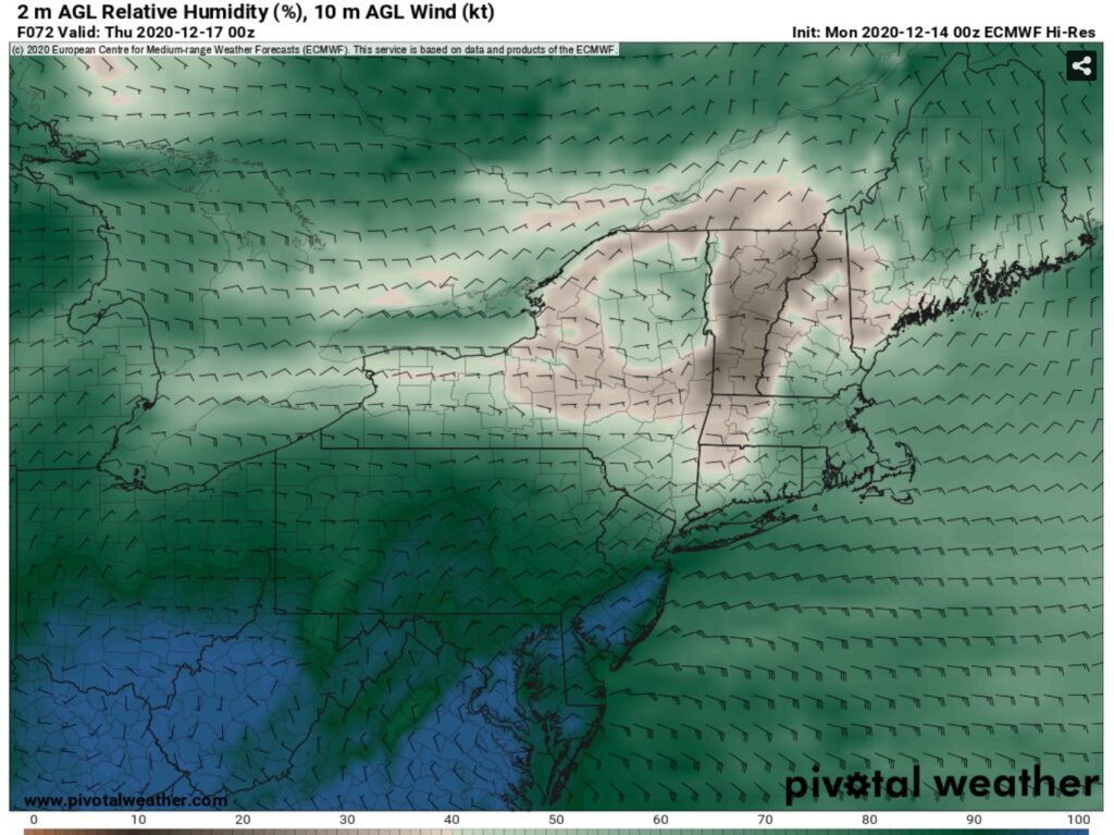
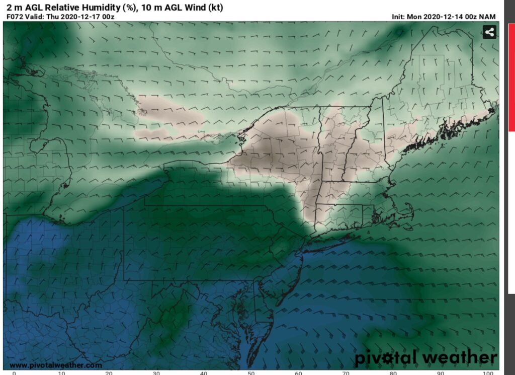
So with lots of dry air near the ground in those aforementioned transition areas, this adds an extra degree of difficulty to the forecast… And with this being a heavy precipitation event with tons of moisture from the south involved, this could very well be a setup like we’ve seen historically where there could be a drastic drop off in amounts… where one county could get over a foot, the next county north only a few inches.
So after all of this analysis, discussion and maps, what is the bottom line?
Timing of the storm for Upstate NY: Wednesday PM (especially after sunset) until morning drive Thursday
This will be a drier snow with cold arctic air in place, so look for snow ratios in the neighborhood of 16:1 (16 inches of snow for every 1” liquid)
High confidence areas along and south of I-88 (Binghamton area, Catskills, areas S of Albany) will see significant snows
Growing confidence significant snows could extend north and west of this area towards the Finger Lakes, Syracuse/Utica/Rome, the Southern Adirondacks and Capital Region N of Albany, but still not certain
Western NY to the Watertown area, St Lawrence Valley, Tri Lakes Region and Champlain Valley are likely to miss the significant snows
Finally for the Tug Hill region, critical for snowmobiling it’s still a big question mark. Not much Lake Effect potential in back of this storm. General snows should be heavier on the southern half of the hill rather than the northern half of the hill. Amounts still highly variable. No way the 24”+ bullseye in the widely shared map verifies on the hill, but several inches is still possible
And finally, since this is a snowmobile enthusiast website, DO NOT EVEN THINK ABOUT HITTING TRAILS AFTER ANY SNOW FALLS UNTIL YOU CHECK WITH LOCAL CLUBS FIRST! SNOW DOES NOT AUTOMATICALLY MEAN TRAILS ARE OPEN. CHRIS RINCK AND I WILL DO A “GUIDE TO YOUR RIDE” PODCAST THURSDAY NIGHT AND GIVE YOU THE LATEST ON WHERE ANY POTENTIAL RIDING COULD BE.
SNOW MAP TOMORROW. I MAY COMMENT ON TRENDS ON FACEBOOK LATER THIS AFTERNOON AND EVENING.
Be good! Thanks for reading this far! Rich

