The northern shift we were hoping and praying for is happening. I still expect the heaviest snow to be along and south of I-88 so Binghamton area, Catskills and areas of the Hudson Valley south of Albany will be the heaviest in Upstate NY. I think overall with the storm the Poconos are most likely to be “bullseye”.
THERE IS STILL GOING TO BE A SIGNIFICANT DROP OFF ON SNOW AMOUNTS ON THE NW SIDE OF THE STORM. THAT LINE HAS SHIFTED 50 MILES OR SO AS THE CROW FLIES NW, BUT THE SAME THING IS IN PLAY. IT’S GOING TO BE HARD NOT TO BUST THIS FORECAST SOMEWHERE. AS ALWAYS WE WILL DO OUR BEST BASED ON EXPERIENCE.
Timing of the snow is from later this afternoon, especially this evening through morning tomorrow, most of it gone by the time morning rush is over. Heaviest snow falls overnight between 11 PM and 5 AM. During this window, snow rates of 1″-3″ per hour are possible, mainly near the highest numbers. Even in areas with lighter accums on the map, it could fall in a burst of only a few hours. Here is the analysis based off the Canadian, which is less aggressive than NAM, more robust than Euro and who cares about the useless GFS at this point. Based on analysis and trends, I believe the Canadian in this situation is the best one to roll with.
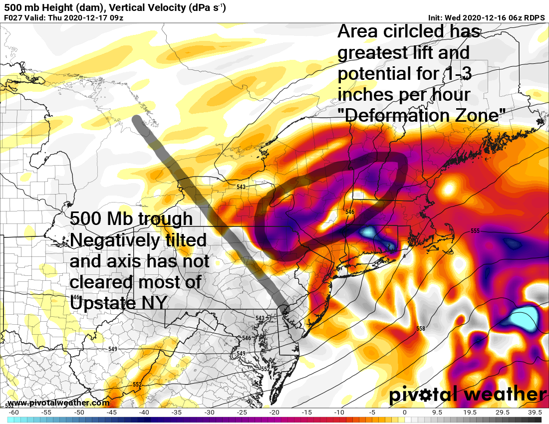
As I discussed in yesterday’s blog, the 500 MB low was hanging back. I told you as long as that’s in play you still have a chance. It’s set up right for a “deformation zone” to form and while it may be brief, I think something will happen with this to the advantage of snow lovers, especially Finger Lakes, CNY, Mohawk Valley and southern Adirondacks.
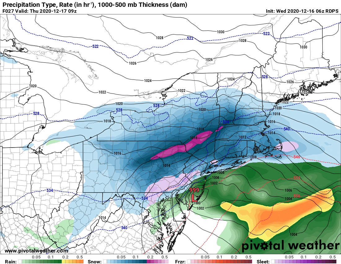
Notice it is not only a little closer to the coast that the last few runs, but it’s a little stronger than the last few runs. Track matters, and it’s close enough to bring the snow away from the big cities. My old buddy from college started playing down the storm yesterday in Rockland County, which makes sense giving numbers going up in the areas mentioned last paragraph.
Bottom line: It’s showtime and this is the final call. We’ll see how this works out:
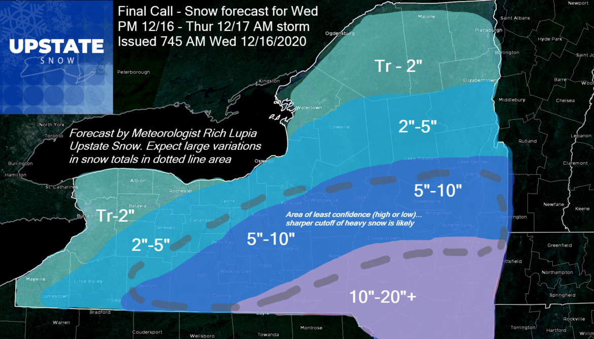
Analysis: Highest bust potential is the Capital/Saratoga Region, especially Albany to Glens Falls, Mohawk Valley, Southern Adirondacks and southern Tug Hill, Syracuse area and Finger Lakes. Lighter snows but close to forecast should be the rule for WNY, Watertown area, St Lawrence Valley and northern half of the Adirondacks towards Tri Lakes and the High Peaks.
It’s going to give everyone more snow and potentially put places that could open for riding (where hunting seasons are over) into play. The nice cold we have had over the last day helps tremendously towards that. The lack of base without any supporting snow and with this being a drier snow similar to lake effect, while easy to shovel, will not hold up well on trails. I guess take what we can get here…
We will follow up with more information tomorrow post storm and get the Guide to your Ride podcast fired up. Any areas that can ride , we’ll let you know. Don’t just go, always check first. Southern zone still closed due to hunting season which is where a lot of the heaviest snow is falling.
We recorded a great Trail Talk with Dave Gleasman last night. We will delay the post of that podcast until tomorrow morning. I’m trying to do all I can but between travel, family in town for the holidays and work, it’s been tough to keep up. Thank you for your patience, understanding and support of Upstate Snow.
Humbly grateful,
Rich


