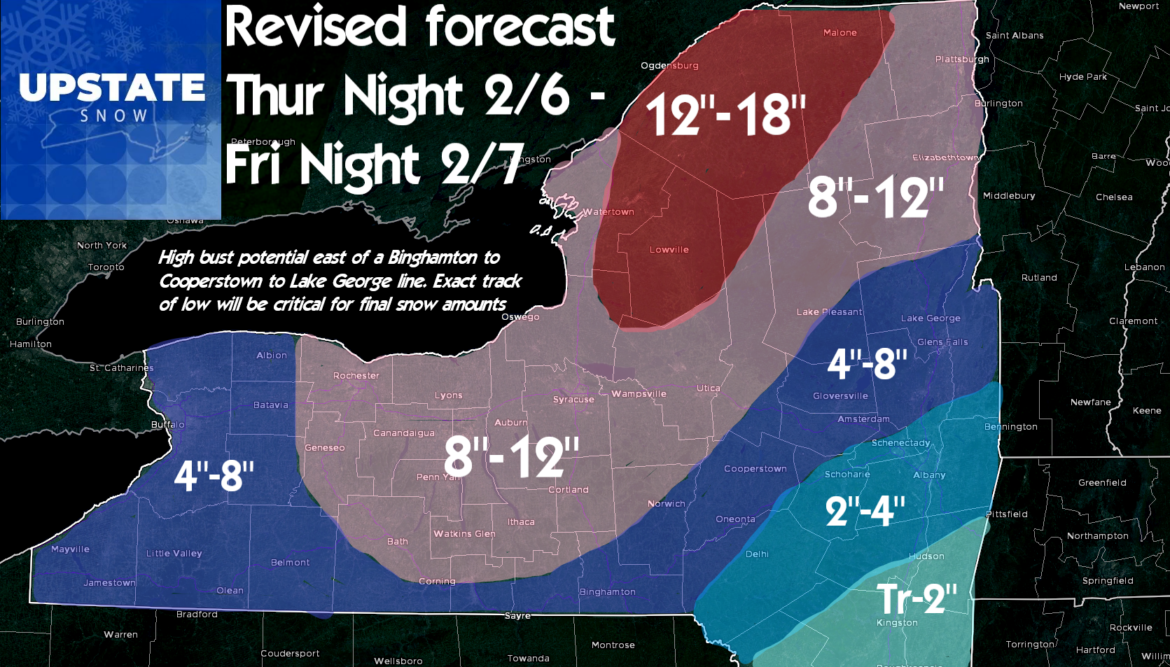
This is our latest forecast on what we think will fall through Friday Night 2/7/2020. Tough call for sure. Models all over the place on positioning of the heaviest snow bands… GFS has rain much farther W than the Canadian and Euro. The zone where I think the highest bust potential is, is near a Binghamton to Cooperstown to Lake George line. Basically within 25-50 miles of that line. This covers most of Central NY, Capital Region, Southern Adirondacks and parts of the Southern Tier. High confidence in heavy snow of a foot plus on the Tug Hill into the western Adirondacks and St Lawrence Valley. Zone of heavy snows but generally at or just under a foot surround it including the central Adirondacks, Utica/Syracuse areas, hills along Rt 20 generally W of Richfield Springs, Finger Lakes and Greater Rochester. In this zone I would not be surprised is a few get over 12″. Best chance between Syracuse and Rochester. All depends on the low track. Decent but not as heavy snows in the Buffalo area and northern and western reaches of the Capital Region. Drops off quickly S and E of Albany closer to the low track and warmer air with less chance for mix.

This storm could overperform. This storm could stay rain longer before changing back to snow and have us reaching just to make low end accumulations. You all know how crazy this winter has been and how much tougher than usual the calls are with so many 32 F mixed precip borderline situations. Why should this change?
THIS IS OUR BEST SHOT AT THIS STORM. Do the snow dance. Hope for this or more than this. Travel during the day Friday will be difficult for most of Upstate regardless.
On the bright side… after this a cold and quiet weekend! Very cold Saturday night with a quick shot of near and below zero temps north of the Thruway. Most all clubs should be open north of the Thruway by this weekend and several S of the Thruway as well. Be sure to check your local clubs, respect signs, landowners and any closures.
Best,
Rich


