
Another storm tonight and tomorrow. Another storm tomorrow night and Valentine’s Day. Yet another storm this weekend. Then another storm after that early next week. Are you sick of me yet???
Good morning! With all of the snow on the ground across Central NY, the Tug Hill, Adirondacks, North Country, Capital Region and parts of the Catskills and Southern Tier, it is no wonder we see many people just getting out to ride! I have not noticed this in years, but today I will bring it about. Last year, when snowfall was so bad you could not even buy it for a dollar… until it was springtime and melted quickly after falling, with about 50% of normal snowfall across most of Upstate NY, my numbers were absolutely through the roof! I mean millions of hits. Several million! This year with the earlier snows in December followed by the generational and historic lake effect snows in early January in parts of Central NY and into the Western Capital Region, followed by straight cold and snow ever since then for several weeks… the numbers are down significantly from last year at this time. For the first time in several years. So once everyone gets a chance to ride, they go away, but when waiting to ride they are at my site with bated breath? That is how it seems.

Having looked through a bit of the site and the Facebook page, there are so many people whom do not like and/or follow the site whom are the regulars on here. Can we help this out some? If you spend ANY regular amount of time on this site, can you please give it a like and/or a follow on the Facebook page? After 12 1/2 years of this, it would be the least you could do to help me on that end. THANK YOU IN ADVANCE!
Now to the LOOOOOONG Weather Outlook. And I mean LOOOOOONG!
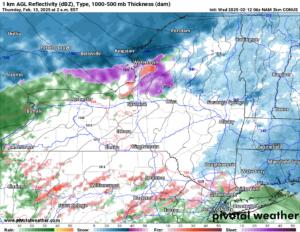
TONIGHT
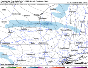
Our storm system approaches from the south and west. Snow develops north of Watertown and generally along the St Lawrence Valley with much heavier snows there, but only within a few miles of the Canadian Border. Away from that, forget about it! Rains also move into Western NY and the Southern Tier. In Central NY, The Capital Region and the Hudson Valley any snow with minor accumulations, just enough to cover the ground with a dusting, maybe an inch at most, will turn to sleet and freezing rain quickly.
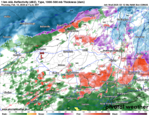
TOMORROW MORNING
The 998 mb low with the storm is centered just south of Rochester. With the west to northwest winds behind it, expect improving conditions across Western NY during the day as rain mixed with then eventually changes back to snow, with light accumulations in the hills south of Buffalo in the afternoon and evening expected. It is remaining sleet and freezing rain, with some rain mixed in across the rest of Upstate NY with temperatures near to above freezing, especially in the lower elevations.
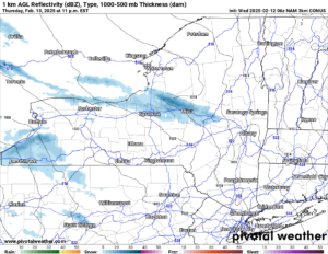
TOMORROW NIGHT
The storm has moved well to the east and has taken all the precipitation with it. What is left is Lake Effect snow. There is minor snows with minor accumulations south of Buffalo, because Lake Erie is frozen over. Off of Lake Ontario, which is not frozen over, expect snow showers with heavier squalls across Oswego, Madison, Oneida and Herkimer Counties.
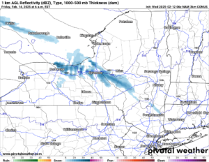
FRIDAY MORNING
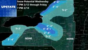
Pretty much between Rochester and Utica, including the Syracuse area, expect snow showers and squalls. Some of the snow will continue to be heavy at times. I would expect the snows to taper off Friday afternoon and be done Friday night. Here is the accumulation map total from tonight through Friday afternoon for Upstate NY:
SATURDAY
Snow develops in the morning across all of Upstate NY and it is snowing at least lightly, if not moderately by the afternoon across most of Upstate NY. How much will we get then? I am not 100% sure yet, however, I think several additional inches of snow are possible, if not likely, Saturday afternoon and into Saturday night across Upstate NY. I will have a full rundown on that storm coming up tomorrow and especially on Friday and Saturday.
SUNDAY
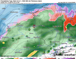
This is where the models are differing with the weekend storm. Some bring the low to our south, keeping this as a moderate to a major winter storm. Other models bring it farther north, changing it to rain across a good part of NY. This example is more of the second solution, with a 988 low centered over Syracuse. That is not good if you want snow. Because if this solution verifies, we go from several inches of snow on Saturday, to plenty of rain on Sunday to melt it down and compact it yet again. Yikes!
SUNDAY NIGHT
The cold front comes through, temperatures nosedive from the 30s and low 40s down into the single digits and teens. Expect another lake effect snow blast to begin across areas downwind of Lake Ontario.
PRESIDENT’S DAY
The lake effect snow, heavy at times, will hit areas generally north of the Thruway so the Tug Hill, Adirondacks and areas just to the north of the Thruway will see the most of the heavy snow here. It will be getting bitter cold again. Temperatures will be in the single digits and teens for highs with near to below zero for lows early next week.
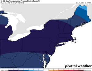
6-10 DAY
Temperatures will continue to run well below normal not just for Upstate New York but for most of the eastern US, especially east of the Mississippi. This runs 2/17 to 2/21. This is seriously cold for most of the Eastern US!
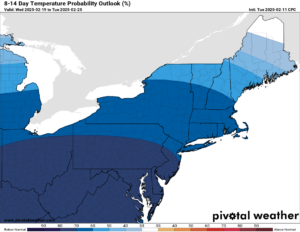
8-14 DAY
Expecting changes in the weather between 2/19 and 2/25??? FORGEDABOUDIT! Seriously. Major cold will continue to have a firm grip of most everything east of the Mississippi including the Northeast and Upstate NY.
We have not had a winter riding season like this since 2014-15. Seriously. We have left out 2017-18 and 2018-19, just because we had a few more breaks in those winters. We am not seeing those breaks anytime soon here. So what are you waiting for? RIDE RIDE RIDE!
Zack and Rich Lupia
Upstate Snow
February 12, 2025
Please thank our advertisers on Upstate Snow for 2024-25
Banner Sponsorship
Great Lakes Equipment
Enjem’s Flooring America
Ohio Ridge Riders
ilsnow.com
Southern Tug Hill Sno-Riders
Saratoga Snowmobile Association
Business Sponsorship
Wedge Life
Paton & Son Excavating and Landscaping
Personal Sponsorship
Jim and Colleen Andre


