
Snow, heavy at times, moves into Upstate NY this evening, hits the heaviest overnight while you are sleeping, then you have to shovel out and plow out to head to church tomorrow morning.
That is assuming that is your plan. I know not everyone is like me when it come to this and that’s OK. Regardless, a decent winter storm is heading in with things loaded. It will somewhat fall apart across western and northern NY this evening and into the overnight, which is why the total accumulations there are closer to 1/2 foot and not closer to a foot like they are in Central NY, eastern Southern Tier, Catskills, Capital Region and the Hudson Valley. For the last two regions, the Capital Region and the Hudson Valley, this could be one of the biggest storms of this year.

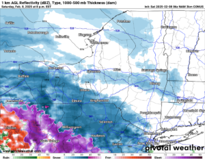
The storm begins to move in this evening, hitting areas west of I-81 by 7 PM. Snow developing, with it being heavy at times, especially closer to I-81.

At Midnight, all of Upstate NY is covered in this storm. Snowfall rates, especially east of I-81 will approach 1″ per hour, and be at that for several hours. That will make it very difficult for traveling. Have plans to head out to a bar tonight and have some drinks? You should SERIOUSLY RECONSIDER. This is not the night or the type of storm to do that in.
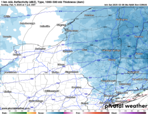
By Sunrise on Sunday Morning, most of the snow has left Upstate NY with the exception of Eastern NY and into New England. That snow will continue to be falling hard where it is falling. When it is not falling, expect relatively calm conditions. Like I said, just leave extra time to get things cleaned up before heading on out to church (or wherever you need to go) tomorrow. Hey, it’s SUPER BOWL SUNDAY! So it’s almost a national holiday for that too!
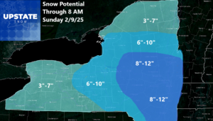
Here is the final snowfall map for Upstate NY for this event. I am sorry I have had to change this more than usual, but we have had several minor changes with this forecast. For Western NY and Northern NY, we will hold the 3-7 inch forecast since that seems the best right now. We don’t see these areas hitting double digits. For the Finger Lakes, Southern Tier and into the Tug Hill and Adirondacks we are putting up the 6-10 inch range with a little more snow. Bullseye is the eastern part of Central NY, eastern part of the Southern Tier, Catskills, Capital Region and the Hudson Valley.
After this we see quiet weather with just scattered snow showers for Sunday, Monday and for most of Tuesday. Now Tuesday Night, a bigger storm will move through, but most of this will pass SOUTH of Upstate NY. But just barely. Any changes will put an accumulation map up starting tomorrow on that.
Thursday is the next significant weather maker for our area with more general snows. The snows may be heavy at times and it could be similar to what is happening tonight. More storms are on the way after that.
So what are you waiting for? RIDE RIDE RIDE!
Zack and Rich Lupia
Upstate Snow
February 8, 2025
Please thank our advertisers on Upstate Snow for 2024-25
Banner Sponsorship
Great Lakes Equipment
Enjem’s Flooring America
Ohio Ridge Riders
ilsnow.com
Southern Tug Hill Sno-Riders
Saratoga Snowmobile Association
Business Sponsorship
Wedge Life
Paton & Son Excavating and Landscaping
Personal Sponsorship
Jim and Colleen Andre


