
OK so Phil saw his shadow. Again. So did everyone else. Again. This week is going to be spring like with near record highs south of Upstate NY (Carolina’s) but what happens after that?
Hello! Thanks for sticking with me. I am sorry I have not been the best as of late. But today’s news should help you. In what has already been the best season for Upstate Snow since 2018-19 for the Adirondacks and Tug Hill, and the best overall season since 2017-18 for everyone, what is the BACK 9 OF WINTER looking like for Upstate NY?

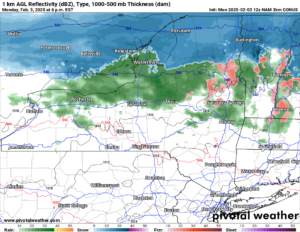
We start off tonight with rain showers in the lower elevations. Higher up and to the north of the Thruway, it is changing to snow in the evening. In some locations, a few inches are possible.
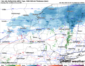
Overnight it goes to all snow over Central and Northern NY with not much hitting the Southern Tier, the Capital Region, Western NY and points south. After the light accumulations you’ll get tonight and see in the morning, most of Tuesday and Wednesday look dry. A mix of clouds and sun will be the rule here with temperatures below freezing.
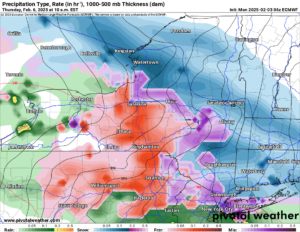
Heading into Thursday, here comes our next storm. It spreads quickly from west to east across Upstate NY. It starts off as snow, then goes quickly to sleet and freezing rain, then to all rain. I was expecting some accumulation on snowfall but just looking at how quickly this is moving heading into our high resolution models, I am not seeing much here.
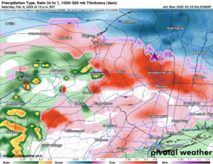
NOT AGAIN! After the Thursday system moves out and Friday and Saturday cool back below freezing, here we go again with another mix/mess storm. Starting Saturday Night, we start with a period of snow. Then sleet and freezing rain. Then rain heading into Sunday. Once again with temperatures going above freezing, I am not expecting all that much snowfall accumulation. But should you be worried about this? No.

The 6-10 day outlook is showing at to below normal temperatures for Upstate NY heading through all of next week. Deep cold win the western and central US with heat in the Southeast US.

On the 8-14 day outlook, the cold continues in the same areas as before. If anything, over Upstate NY, it is showing a greater chance for the cold and snow to continue.

Things are supposed to turn around President’s Day Weekend and especially the week to 2 weeks after that. In this period, daytime average highs start to get above freezing, so anything above normal is not good. With equal chances to just a slight bit above normal we should not be as bad as we could be. There should be a few more periods week 3 and week 4 of February like we are seeing this week.

Overall the month should end just a little above normal. For February this is not the best but it is not the worst either. There will be some western runners doing the snow to mix to rain to snow thing like we will be seeing this week. There may be a few storms that dive south and east of us that turn into Nor’easters. Maybe. But looking overall at the season we have had, how much snow is out there now, especially north of the Thruway, and what is to come… It is looking like the best winter in a long time. So what are you waiting for? RIDE RIDE RIDE!
Zack and Rich Lupia
Upstate Snow
February 3, 2025
Please thank our advertisers on Upstate Snow for 2024-25
Banner Sponsorship
Great Lakes Equipment
Enjem’s Flooring America
Ohio Ridge Riders
ilsnow.com
Southern Tug Hill Sno-Riders
Saratoga Snowmobile Association
Business Sponsorship
Wedge Life
Paton & Son Excavating and Landscaping
Personal Sponsorship
Jim and Colleen Andre


