
Snowfall will return to parts of Upstate NY, particularly downwind of Lake Ontario, over the next 48 hours. After a windy Monday, Tuesday and Wednesday will feature separate periods of light snowfall, probably a few inches worth, followed by bitter cold returning to end January.
That’s pretty much how this last week of January will play out. Through the ups and downs and the snows from time to time, mainly lake effect snows, followed by one more crash back to the Arctic Cold middle to end of next week. There are details you need to know on this roller coaster ride known as the weather. Here we go:

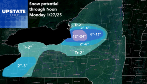
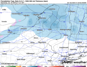
Here is the snowfall map over the next 48 hours. Most of this snow will fall as a weak disturbance moves through this evening, and the winds continue off the lakes through Sunday. The biggest areas for lake effect will be the usual spots downwind of Lake Ontario with a Georgian Bay connection. Just so you know, Georgian Bay is freezing quickly, as is most of Lake Erie and other areas of the Great Lakes. This very cold January has turned the lakes from near record warm, and has taken all of the warmth out of it! It is actually back to about normal now. Amazing!
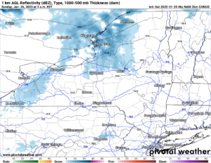
Snow moves in this evening. As you can see it is weak. It’s not even covering the state with accumulations. Only areas downwind of the lakes, particularly Ontario now, will see heavier snows now that Lake Erie has mostly frozen over in recent days.
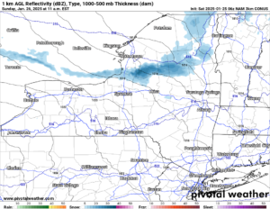
Sunday midday we have the bands of heavier lake effect squalls off of Lake Ontario. These will bring several inches of snow downwind of Lake Ontario. This will gradually weaken by Sunday Night and be basically gone by Monday Morning.
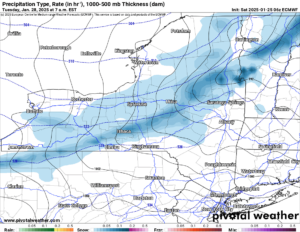
Heading into Tuesday, this is the next clipper system coming through. This one is stronger with general snows across much of Upstate NY. This is where a few inches across most of the state would be much more likely.
Wednesday is the big day. This secondary push of bitter cold air comes crashing through. Temperatures will go from near freezing early Wednesday, down about 20 degrees if not more by Thursday next week. It’s a little too far to call accumulations on this right now. I am thinking Monday will probably be the day I call on this whatever will fall. Then bone chilling cold returns for a few days. The end of next week, temperatures fall to near 10 above during the day and near 10 below at night. This is not record territory at this point of the year, but it’s enough to get your attention!
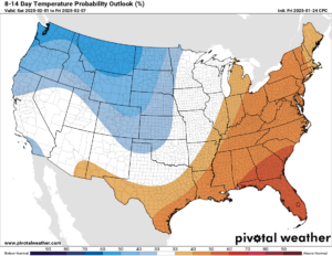
Heading into next weekend and the first full week of February, the CPC is signaling a major turn in the weather. From below zero lows and highs not much above zero, we could very easily jump 20-30 degrees within a few days. Highs could exceed freezing for at least a few days with lows more like the 20s or high teens rather than single digits to below zero.
That is how everything is looking right now. Thank you for your continued support of Upstate Snow!
Zack and Rich Lupia
Upstate Snow
January 25, 2025
Please thank our advertisers on Upstate Snow for 2024-25
Banner Sponsorship
Great Lakes Equipment
Enjem’s Flooring America
Ohio Ridge Riders
ilsnow.com
Southern Tug Hill Sno-Riders
Saratoga Snowmobile Association
Business Sponsorship
Wedge Life
Paton & Son Excavating and Landscaping
Personal Sponsorship
Jim and Colleen Andre


