Wow. Just wow! These are not all of the snowfall reports. But these are some. Once in a lifetime!
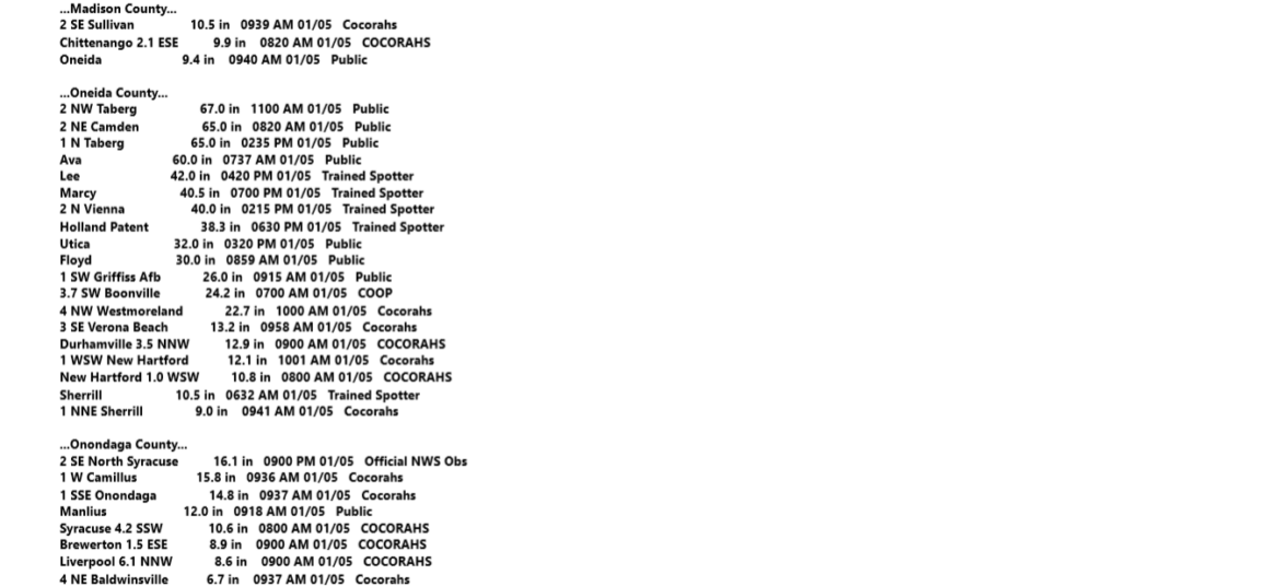
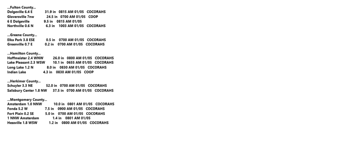
As we get more in later today and over the next few days we will share them. Especially with a map of this historic lake effect snow event. Why do I say historic? In the City of Utica, 32″ of snow was recorded. This is Blizzard of 1966 and Pi Day Storm or “Stella” storm of 2017 territory. That’s the level of snow Utica is digging out of. What did the City of Rome get, especially at Griffiss? Well we know that this is somewhere between a top 5 all time snowfall event, to the greatest all time snowfall event. We aren’t sure yet. When we find out we will let you know.
Just to the north of Rome, from Camden to Annsville, Taberg, Lee, Stokes, Ava, Steuben, Remsen, Barneveld, Alder Creek, Poland, Schuyler, Newport, Middleville, Salisbury, Fairfield, Dolgeville, Stratford, Oppenheim, Ephrathah, and even down to Gloversville, Johnstown, and Amsterdam, this lake effect snow event was historic. Once in a lifetime. You will in all likelihood never see a lake effect snowstorm of this level. Ever again.
Why am I writing so much about this? Because this hit the area I was born and raised in. Where I have spent most of my life. Not right now, but most of my life. And also, after three years, we have formally made the decision. Because of this historic lake effect snowfall event, we have decided that WE ARE COMING BACK! SOON! We will have details on our 2025 snowmobile adventures coming up soon. We are working them out now!
To the areas that I had predicted a lot of snow, and little to none came, I am sorry. I am glad I got most of the historic lake effect snows, but over forecasted for other parts of Upstate NY. When you are forecasting for an entire state all the time, you are going to make mistakes in certain areas. It is just going to happen. And some people won’t resist and will lash out with their anger over how you are always 95% wrong on snow predictions. Those people, if they point their heads up out of the ground, will be banned from this site. This control mechanism has worked well for Upstate Snow. It didn’t initially, but over the years as we have done what we have needed to do. The negative voices have their place, the positive voices have their place. It has gotten us over 20,000 followers since 2012! And more being added every day. So THANK YOU!
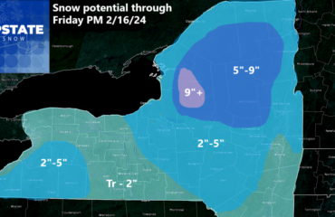
Now to the weather: The snow over Pennsylvania and in the New York City area will shift east, not to the north. This means clouds south of the Thruway, more sun north of the Thruway. Tonight it gets really cold. -5 to +5 for many areas. Some even colder. But nowhere near record cold for this time of year. Tomorrow through Thursday, we have light snows restart over parts of Upstate NY. With a NW flow providing some lake effect. Here is how much we are thinking through Thursday at 7 AM:
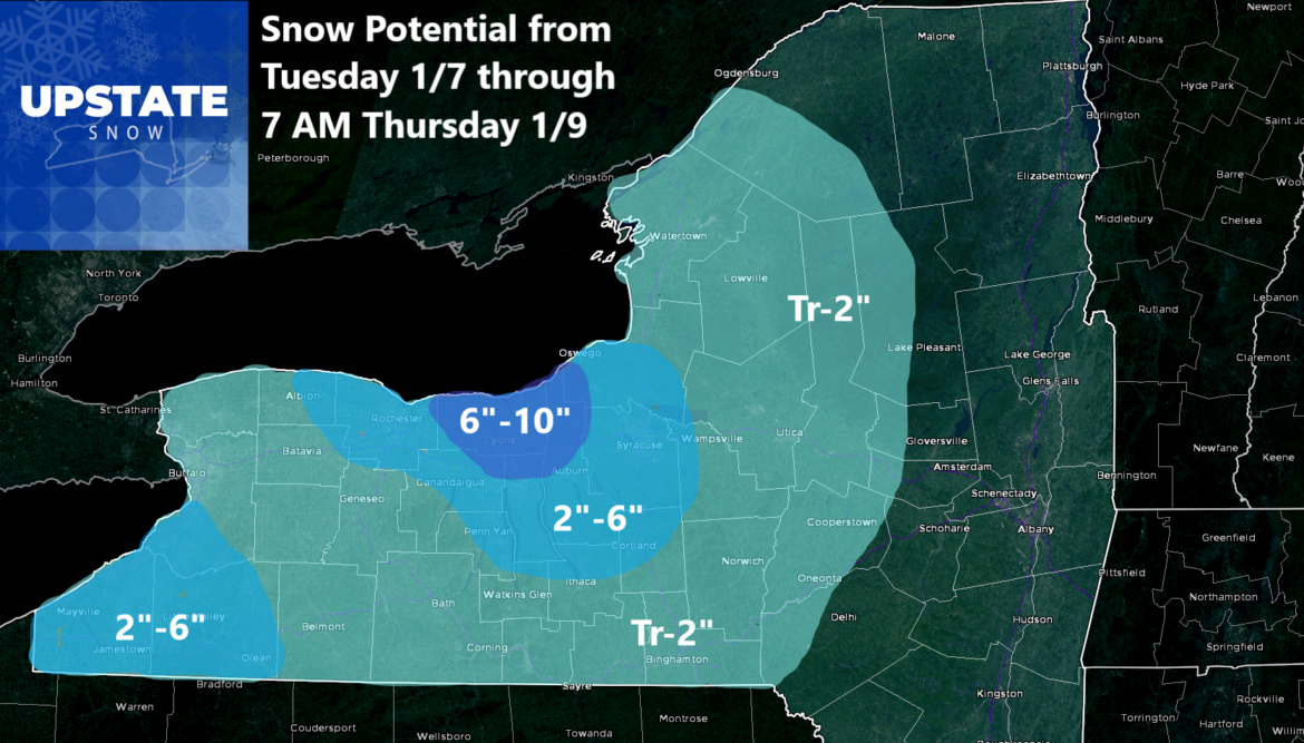
After this, it’s below normal but not by a lot. If anything this next weekend coming up, in areas where you can ride, should be great! Like the Schoff Memorial Ride on Saturday. With 40-50 inches of snow there, what an epic ride that will be this weekend for them! Skies should range from mostly cloudy to partly sunny. To the south, like where I live, the first snowfall in three years is looking more and more likely each model run. Can you say MILK AND BREAD???
Next week another blast of cold air comes on in. And then that’s where we come in. To ride! More on that later. Enjoy your day and thank you for trusting us!
Zack and Rich Lupia
Upstate Snow
January 6, 2025
Please thank our advertisers on Upstate Snow for 2024-25
Banner Sponsorship
Great Lakes Equipment
Enjem’s Flooring America
Ohio Ridge Riders
ilsnow.com
Southern Tug Hill Sno-Riders
Saratoga Snowmobile Association
Business Sponsorship
Wedge Life
Paton & Son Excavating and Landscaping
Personal Sponsorship
Jim and Colleen Andre
Chris Schoff Memorial Vintage Ride – January 11, 2025


