Good evening! This post will be a brief one.
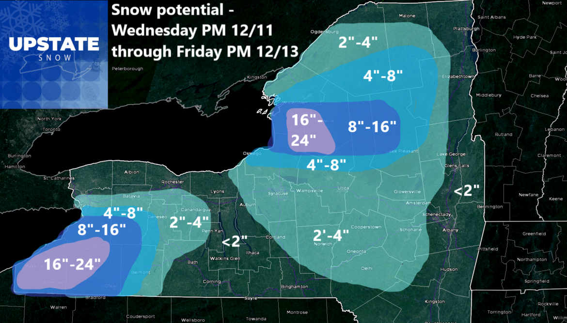
I had already gone into how we were going to go from heavy rain through tomorrow afternoon and tomorrow night (Wednesday) and the change to snow by Wednesday evening west of I-81. East of I-81, the changeover will be later. With the changeover being quicker to the west and this area pulling away more quickly, that will keep snow accumulations lower near Lake Ontario, the Rochester area, and into the Finger Lakes. I feel the best shot of snow with this storm, from the wrap around late Wednesday and early Thursday to the Lake Effect afterwards heading into Friday, south of Buffalo and from Watertown to the center of the Tug Hill is best. Southern Tug Hill will not see as much as friends just to the north. The map is posted above. Please like and share it tonight and Wednesday. It would be appreciated. We will see how exactly this storm plays out.
In the meantime, my biggest fear by far, is a fast meltdown and very high river and stream levels after this storm goes by tomorrow. And losing a lot of snowpack. The next 24 hours will be critical. And the lake effect snow afterwards should all but save Snowdeo, even if they mostly get wiped out. They should get enough to get back into it for snow riding on Friday and Saturday. Pray for them. It so far has been the best winter since 2018. Let us keep it this way!
Zack and Rich Lupia
Upstate Snow
December 10, 2024
Please thank our advertisers on Upstate Snow for 2024-25
Banner Sponsorship
Enjem’s Flooring America
Ohio Ridge Riders
ilsnow.com
Southern Tug Hill Sno-Riders
Saratoga Snowmobile Association
Business Sponsorship
Paton & Son Excavating and Landscaping


