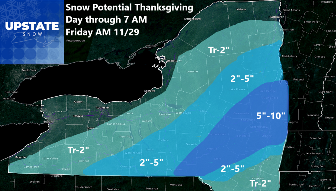
After all of these model runs, after getting blasted to getting none, to getting somewhere in between, here is where we are. This storm on Thanksgiving won’t be the worst we have seen in November. It won’t be the best either. The snow, especially in the eastern Southern Tier, Catskills, and in the Capital Region will be more than enough to be plowing. On Thanksgiving. Other areas will see less and the Dusting to 2″ areas will mainly be on grassy areas, since temperatures will be near to above freezing most of the storm. This snow will once again be a heavy wet snow with a lower ratio of 8:1 or so, maybe 10:1 if we are lucky.
This snowfall is just with this storm and this expires Friday morning at 7 AM. This is not the biggest story here though.
Coming Friday through at least the middle of next week will be a several days long lake effect event. It will be one of the bigger lake effect storms over the last 10 years. Especially given the colder than normal air coming down over near record warm lake waters. I have no idea what to go on for that. Yet. I am just telling you in a few days when I put the top numbers out south of Buffalo and over the Tug Hill, they may be the highest numbers Upstate Snow has ever put out for snow! Seriously. Get ready because winter is about to arrive!
Zack and Rich Lupia
Upstate Snow
November 26, 2024
Please thank our advertisers on Upstate Snow for 2024-25
Banner Sponsorship
Enjem’s Flooring America
Ohio Ridge Riders
ilsnow.com
Southern Tug Hill Sno-Riders
Saratoga Snowmobile Association
Business Sponsorship
Paton & Son Excavating and Landscaping


