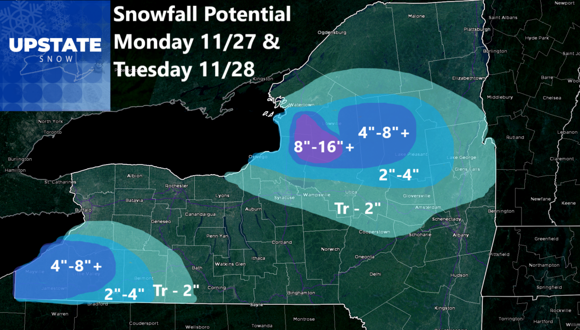
And Good Afternoon! The first significant (Lake Effect) snow of this 2023-24 winter season looks to be imminent for areas off of Lake Erie and especially off of Lake Ontario. It’s cold there now. You know it is WELL BELOW freezing in the mornings. Not much above freezing during the day… if that. So with a significant cooling trend having been indicated for several days across the eastern US, the timing has focused for several days on Monday 11/27 and Tuesday 11/28. Basically since last weekend. With very little change in that pattern, it does look like it shall come to pass.
This afternoon: Some sunshine. Temps within a few degrees of freezing out there.
Tonight: Variably cloudy and cold. Temps well down into the 20s with teens across the north country and Adirondacks.
Sunday: Variably cloudy once again, but in general, clouds shall increase especially midday and during the afternoon. Just before sunset, rain and snow begin to overspread Western NY.
Sunday Evening between 6 PM and Midnight: Rain and snow mix spreads over the rest of Upstate NY as our cold front approaches. It stays as all snow, but just barely for the Tug Hill and the Adirondacks. Depending on how much happens here is really the biggest question on total snowfall accumulations.
Sunday Overnight between Midnight and 6 AM: Precipitation goes back closer to rain…
Monday Morning: Highs for the day from the mid 30s to near 40. Once that cold front comes through, so do gusty winds. You’ll know it.
Monday Afternoon: It’s all snow showers at all elevations around Upstate NY. It’s scattered snow showers over the lower elevations with Lake Effect developing over Lake Erie and especially over Lake Ontario. This is when the snow starts to accumulate where it is falling.

Monday Night: This is PRIMETIME. This is when the colder air really sinks in. It’s snow everywhere. And where the Lake Effect Squalls are, expect 1″‘ or more of snow per hour. This is where you may fall asleep with 1-2 inches and wake up the next morning with a foot. No joke! The alignment in this period is 270 so favoring the center of the Tug Hill. Some northern and southern areas of the hill could hit big, but we are thinking the center of the hill has the best chance right now.
Tuesday Morning: Lake Effect snow showers and squalls head on from due west to east, down more towards the Mohawk Valley, Syracuse and Albany areas. Snow accumulations shall be much lighter. While I expect Utica to get more that a Trace of snow, I am thinking more than 2″ in this scenario is not advisable.
Tuesday Afternoon: Snow showers and a few squalls will continue with little additional accumulation. These snow showers and squalls should end Tuesday Night
Wednesday and Thursday will be quiet days before the next system moves in on Friday December 1. We have nearly a week to look at that so no worries at this time.
Pray for this snow. If it happens, for the first time since 2018, we can ride on OPENING DAY which is just 9 days away in the North Country and the Adirondacks.
Rich


