Well it’s about time to put out another snow map. Now that the cold air has arrived again and will continue to deepen over the next three to four days, it will lead to snowfall over many parts of Upstate NY. What’s worse, the models have been all over the place with this. At first on Thursday, it was looking like we’d get hammered like Halloween 1993, the biggest snowfall so early in Upstate NY history. On Friday, the models we are all like HA HA what the heck were you looking at? Saturday kind of came somewhere in between with snow beginning to show up more north of the Thruway. It also started mixing with the snow earlier as this was getting into the high resolution models as now most of the event was entering the high resolution model territory and their aspects and judgements.
Now it’s Sunday. Now nearly the entire view of these several low pressure areas are within 84 hours now. So we have enough to put out some numbers… CONSERVATIVELY… and hope for the best with them. You’ll see they are not all that large, even where the snow is the heaviest and the colder air is deeper. I mean when you say 1 to 2 inches over a 2 to 3 day period, you are really not asking for much. Here is how I best things are going to play out over the next 84 hours:
This Afternoon: Rain. Rain may be heavy at times. Temps stay from the high 30s to the low 40s.
Tonight: Rain. Rain may be heavy at times. Temps range from the mid 30’s up north of the Thruway to around 40 in the lower elevations of WNY, CNY and the Capital Region.
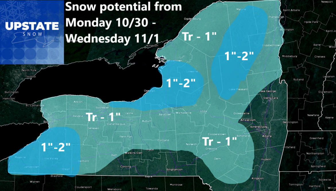
Monday: Next batch of rain is moving through. In this scenario, the air is cold enough to change it to snow in the morning and keep it snow until it begins to taper off later afternoon and evening. The transition to snow only happens north of the Thruway, particularly over the Adirondack Mountains and into Northern NY. Best chances look to be Franklin, Clinton, Essex, Hamilton, SE St Lawrence and N Herkimer Counties. This is where your dusting to an inch (isolated 2″ at most) shall happen. But this is very temperature dependent. If I am off by 1-2 degrees, most of this just ends up a cold rain. We shall see.
Monday Night: Scattered snow showers move south into the Tug Hill and into the areas mainly north of Utica and Syracuse. Also start to move into areas from the Southtowns of Buffalo, southward to the PA line in Chautauqua and Cattaraugus Counties. Any snow showers or any squalls shall be light for the most part with just a dusting to perhaps an inch in spots (indicated on the map) by Tuesday morning.
Tuesday: We start to get some sunshine on this day. Just a little sun. Between that and temperatures holding mainly from the mid 30’s to around 40, any snowfall that happens during the daylight hours on Halloween will barely accumulate to a trace. And not for long.
Tuesday Night: The last batch of moisture and lake effect snow showers, mainly to the Southtowns of Buffalo, and the areas east of Lake Ontario, shall be in play. In these lake effect areas, where not as many people live as say Buffalo, Rochester, Syracuse and Utica, expect another dusting of snow Tuesday Night into Wednesday morning with localized areas getting as much as 1″. In the evening for Trick or Treating, a majority of Upstate NY will see mostly cloudy to cloudy skies with temperatures near to below freezing in the evening. Whatever you do for Halloween, DRESS WARM AND IN LAYERS AT THE LEAST!
Wednesday: Any snowfall ends during the morning and any remaining rainfall should end by the afternoon. The best chance of sunshine shall be in the afternoon. By Wednesday evening, all of this will be over. Except for one more night in the 20s across all of Upstate NY with a hard freeze everywhere Wednesday Night going into Thursday morning.
So after all of this crap, and I do mean and emphasize the word CRAP, here is your forecast total snowfall maps through Wednesday. Again with temps in the 30s to low 40s, there will be some melting and settling of this stuff. Not all of this will stick and blow up like mid winter. It’s the end of October. This is the first real event, although small, of the season folks! Do you realize how many months of this we have left?

Speaking of, now it’s time for us to have a discussion not just on this forecast but on Upstate Snow in general. This site was founded in 2012 by me. I ran it the first two seasons and started the third season in 2014-15, before I got called out on having the site and being told if I kept it I would lose my job. Mid-season on December 27, 2014, I gave the wheels to my good buddy Dave Gleasman, who did an awesome holding down the site for over 4 1/2 years. He increased the number of folks on here from 3,300 to over 9,000 when in late 2019, I was able to take back over Upstate Snow. Now we are approaching 16,000 online with nearly 17,000 followers. You all made it passed my stroke in August of 2022 that came within an inch of taking my life. You’ve seen me go through a year of grueling recovery, and now going into the 2023-24 season, being able to hit the gas full bore. This past week we just finished was the best week Upstate Snow had ever had with more than 1/2 million people having viewed the site in some way. Thank you to all those whom like the site, follow the site, and comment on the site. Well, many of you, but not all of you.
With the articles I have had, many of them being repeatedly shared hundreds of times, including my most shared article ever (October 26 Trail Talk Thursday), it has brought up a part of Upstate Snow that I have not wanted to bring up. It’s what I don’t have to deal with most of the time but I have to deal with now.
THE IDIOTS!!!
We have been around for awhile. This is our 12th winter on Upstate Snow. We have done these snowfall maps literally hundreds of times. All of the information on this site is examined and forecasted directly by me, a Meteorologist with 26 years experience. I get a lot of them, but sometimes I miss some. I miss at least a handful of times per year. Every year. It’s unavoidable the fact I can never be right, every time. Every where. What I am not going to tolerate is the personal bashing of me in any fashion. Again, everything on this site goes out as a FREE SERVICE to anyone who wants to view it. If you don’t like what you see, MOVE ON. DON’T COMMENT. DON’T START TROUBLE. If you do, and if you get personal with me, you will be permanently expelled from this website.
Let me repeat: If you personally bash me for my forecasts or for anything I have done, am doing, or will do, I will hit the delete button and you will be gone. Permanently! Period. End of discussion.
Does this mean I can’t say anything? NO! You can of course say something about me or about my site. Just don’t take it personally, insult gravely personally, or otherwise out come the knives and you are history!
By the way, with the thousands of post comments just over the last 5-10 days, I have a lot of catching up to do.
It is my goal to continue to expand Upstate Snow. I want as many as possible to be a part of this. Seriously. To the vast majority of you people who love what I do, appreciate what I do, respect what I do, encourage what I do, and don’t bash to shreds what I do; THANK YOU!
Thank you for making Upstate Snow Nation the best there is out there!
Rich Lupia
October 29, 2023


