After 60s and record warmth today, a cooldown Friday then Saturday, the first snow event in over a week impacts Upstate NY. This snow event is being measured in inches, at a time of the year when this forecast could be in feet. There is no snow on the ground. Even in the Adirondacks and Tug Hill. We are truly back to square one. And if you think after a few inches of snow the trails are going to open, especially on the Tug Hill and in the Adirondacks and North Country… even in the far northern areas where several inches is possible up in St Lawrence, Franklin, Essex and Clinton Counties??? No kimosabe. Just, No.

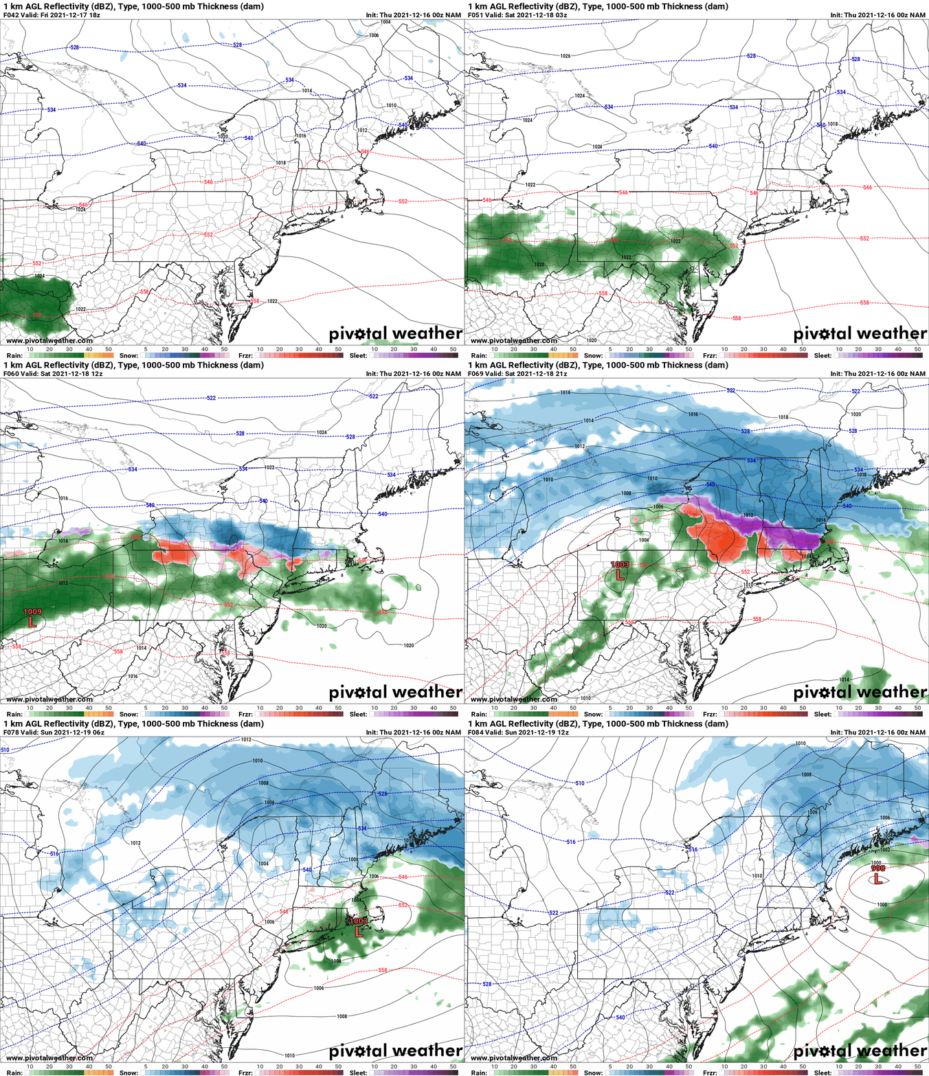
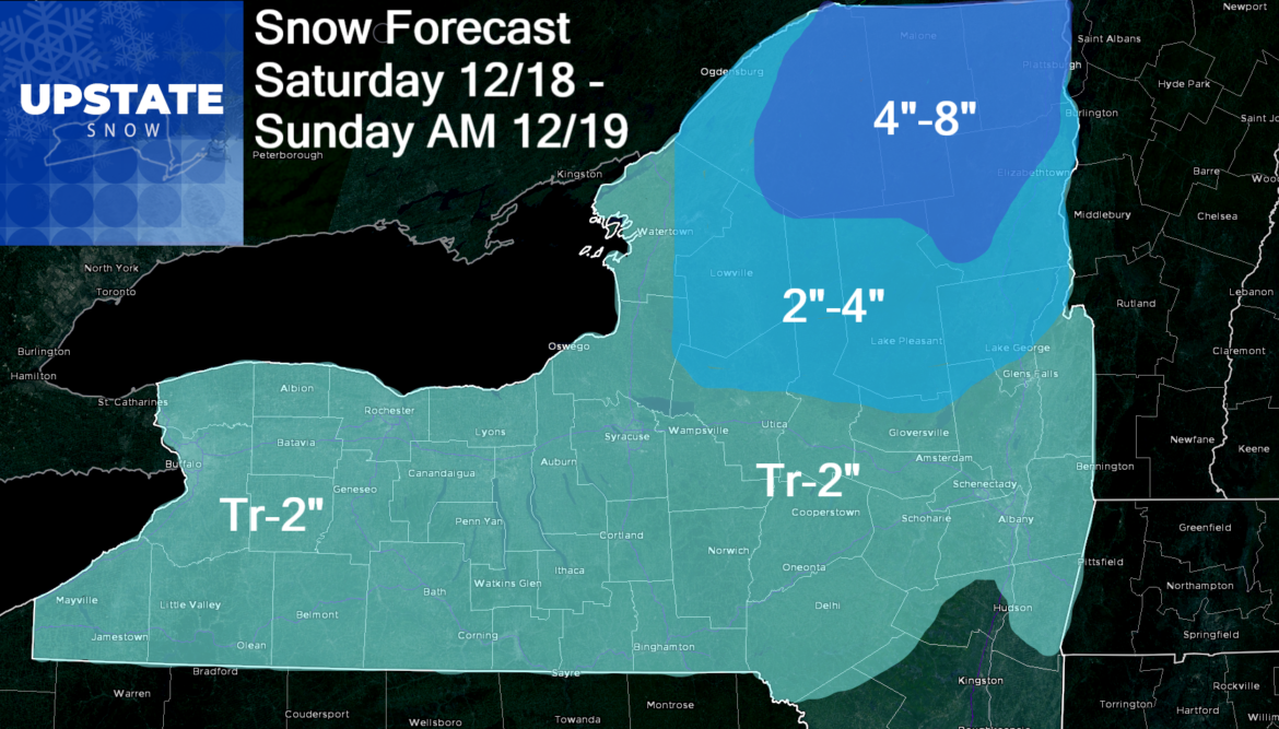
So the setup on Saturday is a complicated one. The record warmth today gets pushed south Friday then makes an attempt to move back into the Northeast on Saturday. This sets up a “cutter” event, then the storm cuts to the south of Upstate NY. The latest model runs, including the NAM shown here, bring this storm farther N. Instead of along the PA Turnpike and south, more like I-80 and even briefly moving into Upstate NY, before transferring its energy to the coastal low developing off NJ and NY Harbor. Because of the very fast jet stream winds aloft, this storm will not last long. Because of the more northerly track, a lot of the state is going to get ripped off, especially from the Thruway corridor and points south. I have a lot of the state in Dusting to 2″, but to be fair with snow changing to rain then ending as snow, 2″ is probably optimistic. From Buffalo to Rochester, Syracuse, Utica and the Capital Region and points south, including the higher elevations, this will be more of a “hey, snow’s back” rather than a plowable snow event. I’d even argue this is borderline for shovelable snow.

The only places I expect actual accumulations to stick will be in the higher elevations north of the Thruway. Tug Hill, Adirondacks and most of the North Country should stay mostly snow, with rain/mix as the storm center makes its close pass late Saturday afternoon into Saturday evening. The ending as snow shouldn’t be a whole lot of snow. In a lot of these transition areas, I could see at least 2″ of snow with potentially as much as 4″. The only areas I think break 4″ of snow, are the areas in which any changeover or mix should not happen. That is St Lawrence, Franklin, Essex and Clinton Counties, the 4 northernmost counties in the state. Here it should stay mainly snow. With it being an overrunning event, and staying mainly snow, I fall back on my UAlbany days and I can hear Eyad Attalah yelling at me, 6″ on WAA precip! So 4-8 in these most northerly areas will be the call.
So what about next week? Colder, yes. Not 40s or 50s or 60s. That ends today THANK GOD. But a whole lot of 20s and 30s will be ahead, especially next week during the daytime hours. Consistent below freezing temps, day and night, which north of the Thruway become NORMAL this time of year, is not in the cards at least yet. The longer range models agree on storms 2, 3 and 4. Here’s the impacts and timing based on the Euro and GFS.
Tuesday 12/21: Weak cold front, light snow.
Thursday 12/23: Weak cold front, light snow.
Christmas Day 12/25 to Sunday 12/26: A potentially bigger storm. This would be mainly snow with some mix especially the farther south you go. Third weekend in a row a storm is coming. Hmmm… a pattern here maybe???
So hopes of a “White Christmas” are not dashed, but only 1″ of snow on the ground on Christmas Day is the low bar to reach that milestone so no big deal there. But in the long range beyond Christmas, hope is increasing of at least NORMAL conditions. No above normal BLOWTORCH events in sight… like the one we have for today. I expect as we close out December 2021, it will start to look and feel more like December going into the holidays, especially after Christmas with better chances for snow and cold. How much cold still TBD. How much snow, still TBD. But the lakes are warm, the patterns are changing, and we could get just enough to start opening up some trail systems if not over the holidays, after the first of the year. Not what you want to hear, or maybe it is. Bottom line, we’ve got a long way to go.
THANK YOU UPSTATE SNOW NATION for your generous support of The Morning Blog, our Podcasts, Videos and more! I truly appreciate your support! Special thanks to those that have given in recent days, despite the lack of snow. To become a MEMBER, drop me $10, and you’ll get name recognition, or if you wish not to use your name, recognition to your favorite snowmobile club or where you live. To become a SPONSOR, drop me $60 and I’ll put up a link to your business, Facebook page or snowmobile club!
Click below to get started
paypal.me/lupiallc
www.venmo.com/u/Richard-Lupia
THANK YOU to our faithful sponsors and members!
SPONSORS
Southern Tug Hill SnoRiders
Saratoga Snowmobile Association
Ohio Ridge Riders
ILSNOW.com
Enjem’s Flooring America
Water’s Edge Inn – Old Forge
Adirondacks Speculator Chamber of Commerce
White Lake Inn
Toads LLC Fisher and Snow Dog Plows, Cairo, NY
John Schoff Memorial Vintage Ride – January 15, 2022
Lincoln Mountain Gansevoort Snowmobile Club
MEMBERS
Chris Rinck
Charles Klesse
Chaz Albertson
Dave Gleasman
John Bates
Darrin Harr
Mark Enjem
Matthew Pistner
Eric Vilovchik
Brian & Paula Bedell
Robert G. Gartley
Chris Higgins
Nathan DeMarco
Frank Presky
Chris Schoff
Richard Keller
Mark Spano
Paul Marconi
Michael Schrader
Chris Skipper
Frank Sansone
Mercy Board LLC
John Scalora
Tom & Alis Vincent
Angelina Gogola
Cricket Corelli
Russ Lamoy


