Sleet for a lot more folks and now freezing rain for some is LIKELY for a good portion of Upstate NY with this storm moving in. I’m going to hit the details you need to know FIRST. After that, what changed over the last 24-30 hours, many of those points if you’ve followed my blog regularly, will not be a surprised because I’ve mentioned them ad nauseum… and finally, how does this impact the next storm Thursday/Friday and the Lake Effect for next weekend.
First things first:
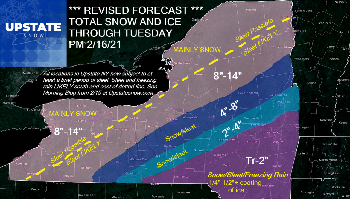
WHAT WE KNOW: Initial shot of snow develops across Upstate NY in the next several hours. For some areas, especially in the lower accumulations on my map, this may be all the snow you see. This initial wave of mainly snow for most, will taper off late this afternoon/early this evening. If you are traveling or planning to ride the snowmobiles this evening, it will be quiet. The heavy precipitation should hit between Midnight tonight and Noon Tuesday 2/16, give or take an hour or two either side. As the heavy precipitation moves in with the approaching low, the warm air aloft will create the potential for at least a brief period of sleet now ANYWHERE. Even far northern NY, Rochester and Buffalo could see an hour or two of sleet. Get south and east of a Jamestown to Oswego to Plattsburgh line, the period of sleet will be more noticeable and it’s south and east of here that the mix could start to cut down on accumulations. This may impact the Tug Hill. Get south and east of an Alfred to Syracuse to Indian Lake to Schroon Lake line, the sleet will become more pronounced and last longer. This is likely to cut down on accums for the Syracuse area, the Utica/Rome area, the hills S of Syracuse and the Southern Adirondacks, especially towards Saratoga and Lake George. Get closer to the Binghamton area, the Catskills and the Capital Region, I expect sleet to be the predominant precip type with freezing rain coming into play as well. Along and south of I-88, and the Capital Region, especially S of Albany, Icing has the potential to be significant. More ice than snow here between Midnight and Noon Tuesday 2/16. Here is the snow map once again.

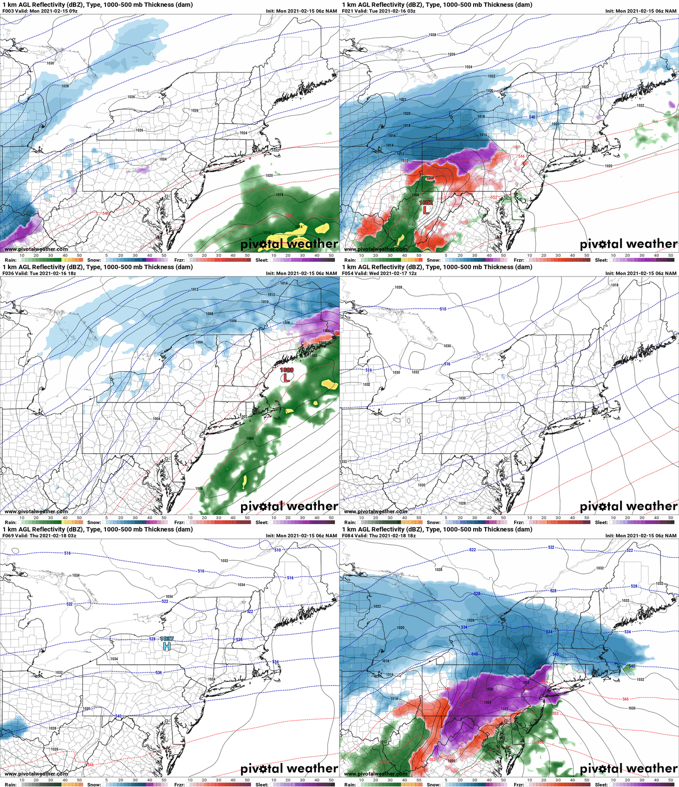
What happened? What changed? Again if you’ve followed the blogs recently, you’ll notice I’ve constantly referenced the coming stormy pattern and my concern we could get too close to the transition from the bitter cold locked in to our west and the building warmth across the Southeast, particularly the Gulf Coast and Florida. As this storm has approached, the model trends kept pushing the snow north and the sleet and freeing rain right behind it. This trend did not stop. Yesterday I watched the satellite and radar trends across the country with a pit in my stomach. The jet stream just isn’t right and storms rarely develop off the TEXAS Gulf coast. The storm track is not a usual one. Models always have trouble handling the extreme cold and the warmth of the Gulf so close together. Watching the Daytona 500, I noticed the storms we moving more north than east. Rain amounts in general over the Southeast were more than predicted… and trends kept pushing the storm more west of the Appalachians. The jump of the low over the mountains to the coast was first from WV to DE. Then it was Pittsburgh to NJ. Now as you see below, yes the low does jump to the coast NJ/Long Island… but what’s left of the main low SURVIVES into NY State and actually traverses the state almost in equal strength to the low on the coast. It means the warm air aloft SURVIVES into NY and we get the mix/mess in a lot more places and a mix/mess of a forecast.

For snowmobilers and the club trails, this is my assessment:
WINNERS IN THIS FORECAST: Western NY, Northern Adirondacks, Tug Hill and St Lawrence Valley.
SPLIT DECISION: Finger Lakes, Central NY and Southern Adirondacks.
LOSERS IN THIS FORECAST: Southern Tier, Catskills and Capital Region.
Looking ahead: Look back above to the NAM. I’ve said many times one storm sets up the other. We still have the Thursday/Friday storm trailing behind this one. You see the initial part of the next storm on Thursday. It starts off as snow, and decent snow at that. Thursday could start off nice, especially with a much stronger high pressure acting to keep the cold air locked in, but the Thursday/Friday storm may also have mixed precip potential, especially for the same areas getting it on this storm. As you’ve seen things change quickly, they could here too. I’ll post an update after this storm winds down either Tuesday PM or Wednesday AM. Regardless of track, next weekend looks cold with a favorable setup for Lake Effect snow for the snow belt areas.
Snow dance right now would help. I’d love for nothing more than this revised forecast to be an overreaction and it turns out to be more snow than expected. I’ll take a blown forecast in that direction, rather than 4-8 becoming less than 2″ of ice. Be safe and enjoy the day.
Rich


