The big storm is here for the next two days. There still remains an unusually high degree of uncertainty with this storm. So lets break this down into what we know and what we don’t know as of 7 AM 02/01/21
WHAT WE DO KNOW: Eastern PA, The Poconos, The Tri-State area (including NYC this time), Downstate NY (The Catskills and lower-middle Hudson Valley), Long Island in 48 hours will be measuring snow totals IN FEET. Some locations in these afore mentioned areas could hit the top ten list of biggest snowstorms in history!
Because of where the storm is stalling and the position of the upper low pressure, as indicated in real time, not by the models, the chances of the bullseye of snowfall getting into the Southern Tier and Capital Region, and points farther north and east is very low.
We know because of the storm stalling, this will send a band of heavy snow tonight into Tuesday AM, north and west through a good portion of Upstate NY.
We know wrap around moisture will have a better chance at getting areas from Albany northbound (Saratoga, Washington, Warren, Essex, Clinton and Franklin Counties) later Tuesday into Wednesday AM.
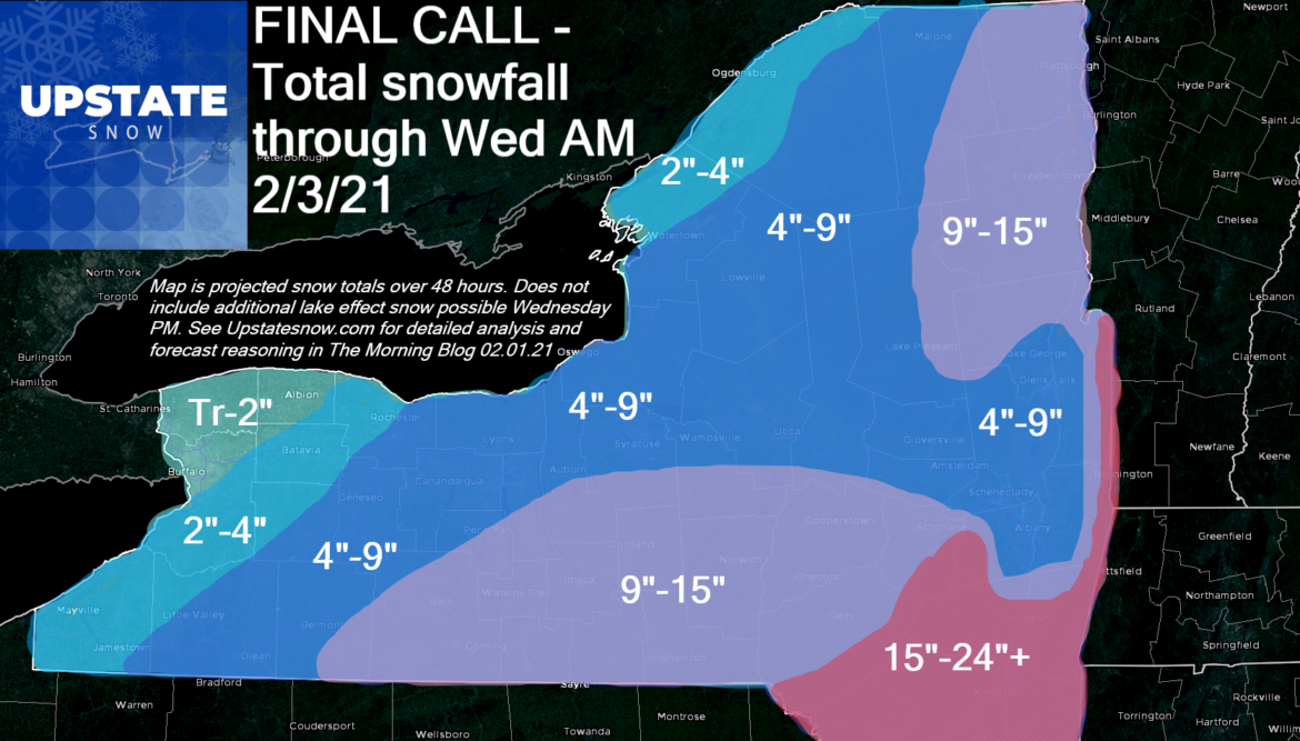
We know there will be additional lake effect snow Wednesday, not factored into these accumulations on the map so as to avoid confusion, for the Syracuse area, hills south of Syracuse and the Mohawk Valley, into the Finger Lakes and the Rochester area (especially east), and likely several inches worth to the EAST of I-390 and to the WEST of NY-Route 12, south of the Thruway.
WHAT WE DO NOT KNOW: How much low level moisture wraps around the storm on Wednesday to give the above mentioned lake effect areas several inches, or locally into the double digits on additional snowfall
How much “downsloping” there will be in the Capital/Saratoga region, and immediately west of the Catskills and Adirondacks. The last time we had this big and intense of a storm “cutting off” and stalling was the “Downslope Nor’easter” of December 1992. This one was a touch farther north, burying the Berkshires, Taconics and southern Green Mountains with 20-40+ inches of snow, while the Hudson Valley and Capital Region proper got less than 6 inches in the lower elevations, mostly from the wraparound. As a teenager and aspiring Meteorologist at the time, I remember the outright anger poured out on the NWS and TV Meteorologists in Albany at the time. It will be a factor and there is absolutely NO WAY I can ignore A) The lesson from 28 years ago I saw with my own eyes B) The fact our models are much more advanced and can pick up on these microscale events much better. That’s why my snow map looks much different than the first one Sunday AM.
How far north does the burst of snow get tonight and Tuesday AM. For areas well to the north like the Mohawk Valley, Syracuse area, the Tug Hill and a lot of the Adirondacks, this is where the majority of the snow on the map will come from. I cannot bank on 6″+ of wraparound, even in a stalled storm, because I have rarely seen over 6″ of just wraparound snow outside of the high peaks, hence the different snow map.
Is there a dry slot that works into this storm that messes everything up? I’ve seen that before. Given the year and times we are living in and the crazy storms we’ve had the last few years, I can feel a curveball of some kind coming. I just don’t know what it is yet. Eyes on the storm.
BOTTOM LINE: Unless you live south and east of Interstate 88, or south of Albany County (where it is a storm to take VERY seriously), this storm will be an off and on event. There will be periods it’s a full on squall, others just flurries and snow showers with no accumulations for several hours as the storm goes through it’s phases. Remember it is a 48 hour event. Blowing out comments of “it’s a bust” before Wednesday morning, before the end of the storm is pompous and irresponsible. Look, I know despite hours of analysis and my best efforts putting together a snow map for an area as big as Upstate NY, it’s next to impossible to get it perfect for every single town and county across this big of an area. But I’ve always loved the challenge, and I know many rely on the expert opinions given here. That being said, my chips have been pushed to the center of the table. We are ALL IN with the following:

So lets break this down by region with commentary. I’ll start with the elephant in the room that’s blatantly obvious on the map. The Capital/Saratoga Region. I’m calling downslope, which will keep the big snows up in the higher elevations. I cannot put double digits for the Cities of Albany, Schenectady and Troy. I can’t do it. December 1992, plus current trends, plus the mesoscale models saying “hey… downslope” have me leery of pushing 10″. I’m telling you right now, if I’m right, I’m golden. If I’m not, I will bust it being several inches low. I’m aware of this. And I know I got nailed way low on the 12/15 storm. Still, I say majority of the population at lower elevations stay under 10″. We shall see.
East of the Hudson, the closer to Route 22 you get, snow totals will change DRAMATICALLY. Helderburgs and the Catskills… MOUNT CRUSHMORE. Ok, I stole that line from Darrin @ Ilsnow. Get south of Route 23 heading into the Mid Hudson Valley, legit big snows, even in the valley as downslope not as big of a factor there plus closer to the storm.
The Western Catskills, Delaware, Otsego County and getting closer to the Binghamton area, I didn’t extend the big snows that way because of the same downslope reasoning I used for the Capital Region. But higher amounts because closer to the storm. Again, same scenario here. If downslope doesn’t happen, I will bust here being too low.
I am holding more snow over the Eastern Adirondacks, mainly along and east of Route 30. In patterns like this, the upslope flow will hit these areas along and east of Tupper Lake, Long Lake, Blue Mountain, Indian Lake and Speculator much better. Gore will get crushed, probably way more than 15 on the mountain itself, 9-15 good in North Creek. Here also, the wrap around snows Tuesday PM to Wednesday AM will add to it.
Mohawk Valley, Syracuse areas W to Rochester, and north into Western Adirondacks and Tug Hill. Again, I could see 9″ easily, but I am still leery of going widespread double digits. Between distance from the storm, relying too much on the band of snow tonight and tomorrow morning for most of the accums, I’m going to sit 4-9.
West of Rochester to the Buffalo Niagara area it gradually drops off. More in the higher elevations to the south where snow has already started. But here it will end by tonight for most with the action to the east on Tuesday.
So there it is. My best shot. Let the chips fall where they may. Some additional lake effect possible Wednesday PM, and all the talk about big wipeout thaw at end of the week. Table it for now. This storm will have a major impact on the weather to come afterwards. Enjoy the snow, be safe, travel safe, respect the clubs. The heart of the winter is here and now.
Rich


