Snow will indeed hit Upstate NY despite our analysis three days ago that said otherwise. It’s a funny reversal. If you remember back to the beginning of December, before the December 15th incredible storm that hit the Southern Tier and Eastern NY, There was a “bullseye” hit for most of Upstate NY indicated three days away and I called wide right… and was right. Eastern New England got nailed and Upstate NY was lucky to get snow showers. Now it’s the reverse! Great news for snowmobilers all across Upstate NY. While the heaviest accumulations should stay Downstate, PA and Southern New England on this one, we will get something decent.
This is a FAST evolving situation. Models are all over the place from skunking parts of Upstate, to dropping history shattering amounts in Eastern PA and Downstate NY that rival the all time greatest snowstorm, the Blizzard of 1888. I don’t believe either extreme at this time. Any outlet that focuses on this is doing it for clicks or taking a bet they could be right. There is not 100% certainty on any outcome at this time.
So what changed? Three days ago in the morning blog I went into why the storm would go offshore. It was predicated on a huge storm crashing into California, sending the ridge east into the plains which therefore would send the storm east instead of up the coast. This is not happening, therefore the door is open for the storm to nearly stall in a good spot to drill Upstate NY and all of the Northeast.

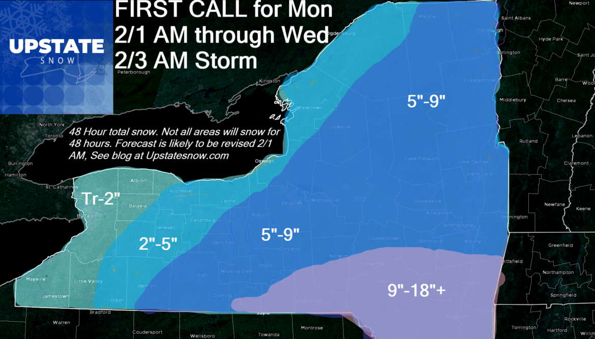
With this in mind, our 48 hour snow map. This is a FIRT CALL. EXPECT A REVISED MAP TOMORROW IN THE MORNING BLOG. AMOUNTS IN YOUR AREA COULD GO UP OR DOWN.

There will be additional lake effect on Wednesday, not factored into this. Tug Hill, CNY and hills south of the Thruway would be best chance for bonus snow Wednesday at this time. Amounts TBD.
STAY TUNED…
Rich


