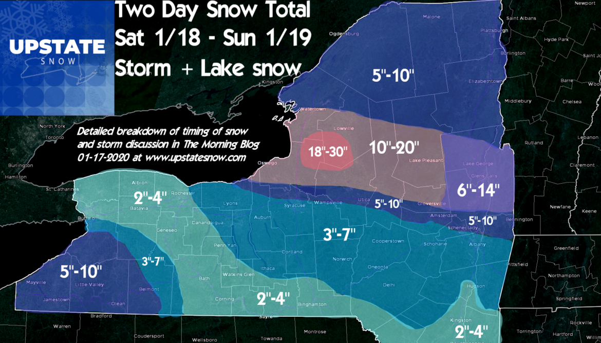
This is a very complex forecast with high bust potential for certain point locations, mainly close to the Thruway. Please read full text below for details on how/why I forecasted what I did.
It will be quiet through today with minor lake effect snows diminishing west of I-81 as cold and dry air builds in. Tonight into Saturday morning will be very cold, especially east of I-81.
Saturday morning our storm approaches from the west and spreads snow across all of western and central NY. By 10 AM – Noon the snow will spread east of I-81 and by 1-2 PM it should be across all of Upstate NY. Snow that falls on Saturday will be general and a steady light to moderate snow with a decent water content to it, a little packy. With the storm center tracking on the north shore of Lake Erie and up to near Toronto by Saturday Night, this will spread warm air aloft and at the surface into areas west of I-81. This means a sleet/frz rain mix with some areas, especially Greater Rochester and the lake plain along and N of I-90 into Buffalo, the northtowns, Niagara, Genesee and Orleans Counties will see the least accumulation and the best chance for mix and changeover. Even in the southtowns and western Southern Tier this may happen Saturday afternoon/evening.
The cold high pressure will hang tough east of I-81 and most of Central NY, Catskills, Capital Region, Tug Hill, Adirondacks and St Lawrence Valley should remain snow. Don’t be surprised if sleet mixes briefly, but only for a short time late Saturday afternoon/evening, and will have minor impact on the accumulations.
There will be a zone of steady moderate snows on the north side of the Thruway from Syracuse to Albany with these SW winds aloft not only lifting the warm moist air up over the colder air near the surface, but this is an upslope flow. Areas from N Oneida County to N Herkimer, Fulton, Hamilton, Saratoga and Warren Counties, even Washington County, will see enhanced snowfall from this Saturday afternoon into Saturday evening from the main storm itself. Just Saturday afternoon/evening alone, these locations mentioned above will likely exceed 6″ of snow and maybe even get to double digits just on this snowfall alone by the time you go to bed Saturday Night.
FOR MOST AREAS OF UPSTATE, INCLUDING SOUTH OF THE THRUWAY, EAST OF I-390 ALL THE WAY TO THE HUDSON VALLEY, MOST OF YOUR SNOW FALLS SATURDAY. THIS INCLUDES ELMIRA, FINGER LAKES, ITHACA, BINGHAMTON, CATSKILLS, HUDSON VALLEY AND CAPITAL REGION SOUTH OF THE CITY OF ALBANY.
Overnight Saturday into Sunday morning the Low pressure tracks along the NY/Canadian border and ends up near Montreal and Sherbrooke, Quebec. This position of the low pressure is KEY to the lake enhanced and lake effect snow that will develop almost immediately behind the low as you are sleeping early Sunday AM into the morning hours Sunday. From when you wake up Sunday, through the day, this will be a solid and respectable lake effect snow event unfolding for a zone near the Thruway to the center of the Tug Hill, Old Forge, southern half of Hamilton County, and still accumulating snows continuing east into Saratoga, Warren and Washington Counties on a strong and gusty W to WNW wind.
In this zone of lake effect snow Sunday morning into Sunday afternoon, expect significant accumulations, near whiteout conditions with gusty winds above 30 MPH at times, and difficult travel conditions.
Mean low level wind direction looks to be between 275 and 285 degrees. This favors THE SOUTHERN HALF OF THE TUG HILL. BARNES CORNERS, MONTAGUE AND LOWVILLE WILL GET LESS THAN OSCEOLA, TURIN, C’VILLE, HIGHMARKET AND BOONVILLE. BIG MOOSE AND STILLWATER WILL GET LESS THAN OLD FORGE, INLET AND MOOSE RIVER PLAINS AND PERKINS CLEARING ON THIS WIND DIRECTION. THIS WIND DIRECTION IS FAVORABLE FOR NORTHERN ONEIDA COUNTY (TC RIDERS, LEE CENTER, LOST TRAILS, PENN MOUNTAIN, TRACKSIDE CLUBS), CENTRAL HERKIMER COUNTY (OHIO RIDGE RIDERS), SOUTHERN HAMILTON AND FULTON COUNTIES (MOOREHOUSE, PLEASANT RIDERS, DRAG OF SPECULATOR, WELLS, STRATFORD, OPPENHEIM, SOUTHERN ADIRONDACK, MAYFIELD, MULLEYVILLE SNOWMOBILE CLUBS)
ANY DEVIATION OF THE WINDS ON SUNDAY WILL HAVE A BIG IMPACT ON SNOWFALL. THERE WILL BE ON SUNDAY A VERY SHARP SOUTHERN CUTOFF OF THE SNOW OVER THE DISTANCE OF JUST A FEW MILES. YOU COULD HAVE TWO DAY STORM TOTALS OF 18″ WITH PLACES JUST MILES MILES SOUTH NEAR THE THRUWAY WITH AS LITTLE AS 4″. PLEASE KEEP THIS IN MIND. BUST POTENTIAL FOR THE FORECAST IN THE UTICA/ROME AREA, MOHAWK VALLEY AND AREAS OF THE CAPITAL DISTRICT LIKE AMSTERDAM, GLENVILLE, CLIFTON PARK IS HIGH, ESPECIALLY WITH THE LAKE EFFECT.
I have an enhanced zone of heavier total snows over Saratoga, Warren and Washington Counties, the northern 1/2 of the Capital Region. You will get hit with snow both Saturday from the storm and Sunday from lake effect that makes it to you (something that doesn’t happen in every storm). There will be a HUGE difference in snow between exit 9 and exit 15 of the Northway (Clifton Park to Saratoga).
The immediate Capital Region gets most of the snow Saturday with Albany, Schenectady, Troy and points south quiet most of Sunday, just windy.
Most of the snow totals over WNY, especially Chautauqua, Cattaraugus, Allegheny, southern Erie and Wyoming Counties will be from lake effect of Lake Erie Sunday morning and early afternoon. Most of the lake effect misses Greater Rochester, City of Buffalo and northtowns.
The lake effect snow late Sunday afternoon into Sunday night will begin to weaken, turn into weaker multi bands of snow and shift into a NW wind flow into the Utica/Rome, Syracuse areas, hills along Route 20 and the Finger Lakes.
MLK Day and Tuesday will be general quiet, with minor lake snows possible, breezy and mid-winter cold. Wednesday will still be cold, Thursday and Friday a moderating trends. I won’t go into that now. Some models wanting to push it back above freezing by late week into next weekend before we get reinforcing cold into the last week of January. Just know I know about it, am nervous about it and will tackle after this storm.
FOR SNOWMOBILE RIDERS, PLEASE DOUBLE CHECK WITH CLUBS BEFORE YOU GO. REMEMBER THERE IS NO BASE IN MOST AREAS AND WATER AND BLOW DOWN IS STILL A BIG ISSUE ON THE TRAILS. THOUGH IT’S MID JANUARY, CONDITIONS WILL BE MORE LIKE THE START OR END OF THE SEASON. WATCH FOR HAZARDS, SLOW DOWN AND HAVE REALISTIC EXPECTATIONS.
AND IF YOU HAVE SICK OR PERSONAL DAYS TO USE, BE OPEN TO THE IDEA OF DUMPING ONE AGAIN MIDDLE OF NEXT WEEK AFTER CLUBS GET THIS SNOW PACKED AND GROOMED, IN AREAS THAT GET RIDEABLE SNOW.
We will update on the website and Facebook. Expect at least one live FB update during the snow Saturday and Sunday.
Rich


