Good evening…
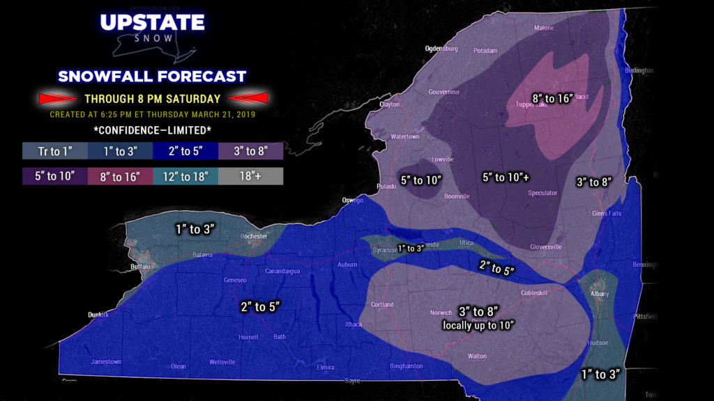
Late season storm will bring heavy snow to the Adirondacks, the Tug Hill, most of the Catskills and Susquehanna region beginning late tonight and lasting into Saturday.
The big picture hasn’t really changed. A rapidly strengthening area of low pressure will move from the Delmarva to Long Island by early tomorrow morning. A second area of low pressure will be riding up the St. Lawrence with a trailing cold front. Look for rain to change to snow overnight / early Friday morning… first in the higher elevations, and then to the valley floors by late morning or early afternoon, with windy conditions and falling temperatures. The winds will REALLY pick up by early Friday evening as our low bombs out just off the coast of Maine. Heavy snow will be the result.
We have tweaked our snow map a bit, mainly over the Adirondacks and the Tug, where we believe higher amounts of snow could fall. This is still a LIMITED CONFIDENCE FORECAST, and a few degrees of temperature change or a shift in storm track can result in a catastrophic busted forecast. Modeling also has differences in opinion with regards to snowfall. Therefore we felt it best to keep it close to what we had outlined last night. We did add a color of 8-16 for the highest terrain in the ADKs, and we’ve bumped the Tug to 5-10.

These totals run now through 8 PM Saturday. These totals are also VERY DEPENDENT ON YOUR ELEVATION… ESPECIALLY over the Susquehanna Region. City areas such as Norwich and Oneonta may only pick up a few inches, but get out of town and into the hills, Gilbertsville, Morris, etc., and you can expect quite a bit more.
Blowing and drifting of snow will also be a hazard Friday afternoon into Saturday as a strong northwest wind flow wraps around our departing system. All snows should rapidly come to an end by Saturday evening.
High pressure briefly settles in before a fairly unusual cold front (running virtually due west-to-east) drops down over the state Monday. This will bring a renewed push of colder air and some snow showers. The modeling wants to spin up a new low pressure on this front, pushing it from the Ohio Valley to the coast, but we believe the front pushing southward will keep most of the precipitation with it. That being said, the FV3 does spin up another fairly deep low off the Delmarva/southern Jersey coast by Tuesday afternoon.
Conditions SHOULD be quiet thereafter, with temps running a touch below normal.
LETS GO RIDING! As mentioned last evening, this storm is going to re-energize some of our areas. This will make for better lake crossings and improved trail conditions in the Adirondacks and on the Tug Hill through next week. BUT… where trails have closed, don’t just rush out there. Double check with clubs first… some landowners may have already closed gates. Always respect landowners and clubs!!!


