Good evening…
Tonight’s report will focus on the lake effect event(s) expected this week east/southeast of Lake Ontario. We say event(s) because both will have a definitive start and stop point.
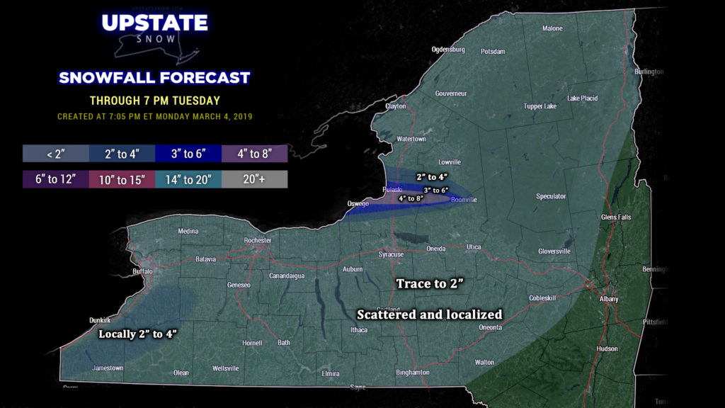
Event #1: A narrow band of lake effect is expected to become established east of Lake Ontario, impacting extreme northern Cayuga county and southern/central Oswego County, through Tuesday morning. Last night we spoke of a very deep low pressure center located way off to our north, which will spin little “frontal boundaries” down across the state. One such boundary will drift over the early tonight, and once it does the lake band will really come alive, impacting central Oswego county… Oswego and Pulaski eastward to the southern Tug… perhaps as far east as Boonville. We’ll go with a 4-8 total in this area, but not everyone in that area will see those totals — the band will be narrow, and tend to work its way northward during the overnight into early Tuesday. As we go through the day Tuesday this band is shown by our high-res modeling to drift northward even farther but to “shrink back” toward the lake, ahead of the next “frontal boundary.”
The next boundary drops across the state Tuesday afternoon or early evening and kicks off several “bursts” of snow across much of central and western NY. This won’t amount to a lot, a trace to a couple of inches at the most.
Some lake effect will occur off of Lake Erie, but don’t get excited, the scope will be limited thanks to ice cover.
Our snow accumulation map through 7 PM Tuesday illustrates what has been stated above. Not everyone will see snow; it’s impossible to really pinpoint who will and won’t, so we have broad-brushed things a bit. To arrive at these numbers, we essentially went with a blend of the short-term modeling. The target area is, again, Oswego to the southern Tug through 7 PM Tuesday. We did paint in a faint area of “locally 2-4” east of Lake Erie just to cover the possibility, but that’ll be the exception more than the rule.

Event #2: This one isn’t going to be as easy to put together, in terms of the location, who gets the most, etc. Behind that “frontal boundary” winds will want to turn a bit southwesterly for a little bit. Deeper moisture across the area (thanks to that boundary) will mean a plume gets started Tuesday evening, with Jefferson County in the crosshairs… but our modeling suggests that’ll be kind of short-lived. The winds become more west, and then west-northwest during the overnight hours into Wednesday morning, and our band sinks southward in response… but not before several inches of snow accumulates in Jefferson county. The WNW winds line up verrrrry nicely with all that open water on Wednesday, and our band will push southward through Oswego county before settling for a cup of coffee across northern Wayne and northern Cayuga counties, and then lining up along the Onondaga/Oswego county line, extending eastward through central Oneida county (mainly north of the valley). The next “frontal boundary” zips across the area Wednesday night, providing a fresh dose of Monster energy to our lake band… winds become nearly due-west, and our band lifts just a bit northward once again to pummel a large portion of Oswego county and most of central/northern Oneida. At least… if you believe what modeling would suggest (as well as previous experience). The lake band may also impact the southern shoreline, mainly along and north of route 104. We’re not going to make any calls on snow amounts but some areas will likely see over a foot of new snow between Tuesday evening and late Wednesday night.
Oh, and while we’re at it, that “frontal boundary” Wednesday night will also bring additional snow showers across much of the state outside of the lake snows.
Again, Lake Erie counties will have limited impacts thanks to all the ice. There will still be some lake snows, but probably similar to what we’ll see tonight through Tuesday, generally in the 1-3 or 2-4 inch range, depending on where you are.
Event #2 comes to an end during the day Thursday.
For Friday, a fairly weak area of low pressure will move from the Ohio Valley, across northern Virginia, and off the coast. This may bring some generalized light snows to the southern tier.
Then the focus turns toward the end of next weekend and what is looking more and more like a storm system similar to many others that we’ve had this season… so enjoy the early-January-like weather and lake snows while we have it.


