Good evening everyone…
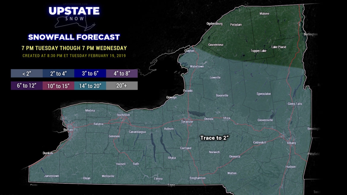
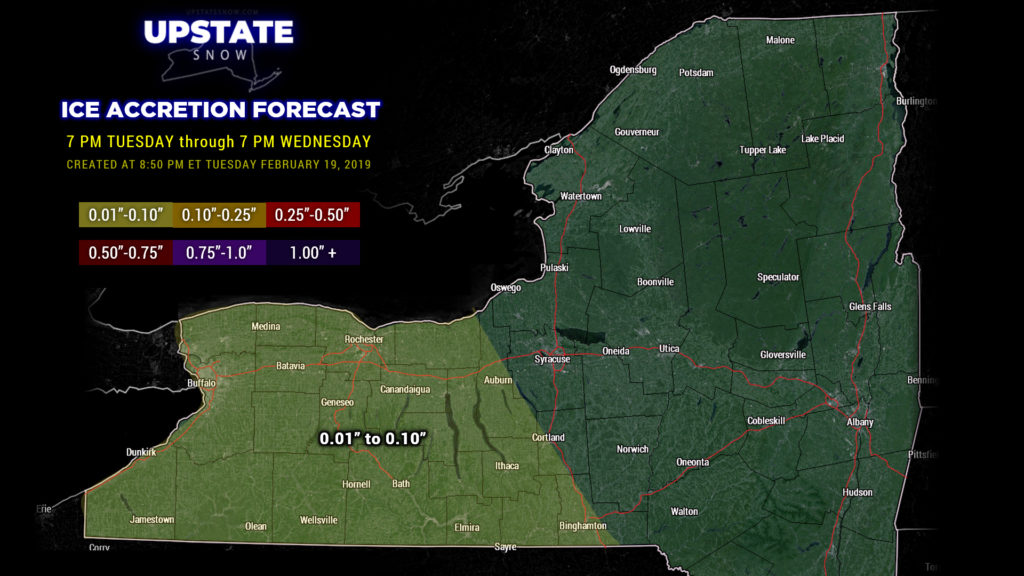
Another mess headed our way as Winter Weather Advisories are up for Wednesday and Wednesday night for all but the northernmost portions of the state. This is primarily for the mixed precipitation headed our way… a couple of inches of snow with roughly a tenth of an inch of ice accretion. . So let’s break it down:
High pressure will try to hang tough over the state through the day Wednesday. The latest high-res modeling shows an area of snow lifting northward into the Southern Tier by mid-afternoon… advancing northward into the ADKs by mid-evening. With this overrunning moisture will come warmer temps aloft… this will cause a transition to sleet and then freezing rain… initially late in the afternoon for the NY/PA border counties, also lifting northward into the evening hours.
We’ve painted out snow map “trace to 2 inches” through 7 PM tomorrow evening. By that time most areas south and west of a line from Watertown through Hudson should have transitioned over to sleet/freezing rain showers. Some light icing is expected for most of the area into the early evening.
As we move into Wednesday night the high-res modeling shows colder air hanging on into the overnight hours, keeping mixed precipitation going for a large portion of CNY, with a transition to light rain showers for the far southwestern corner. Surface temps go above freezing for just about all areas south of the Valley during the pre-dawn hours, and precipitation tapers off to just a few scattered rain showers.
Thursday– The main low pressure center with this system lifts northeast across Ontario and Quebec, dragging a cold front across the state early in the day. Leftover rain showers transition back to snow showers during the afternoon, and a bit of lake response sets up off of Lake Ontario. Scattered snow showers should continue Thursday night into early Friday.
As mentioned, light icing can be expected across mainly areas west of I-81 during the later afternoon Wednesday. Expect that icing to continue over the rest of CNY on Wednesday evening into the overnight; amounts generally a tenth of an inch or less, maybe some isolated higher amounts. Snows, again trace to 2 inches for most of the state through early tomorrow evening (probably closer to “trace” in many areas); snow accumulations along the Canadian border will occur Wednesday night into Thursday. Looking at modeling, that will also probably be on the order of 2 inches or less.
Total liquid equivalent / liquid is still expected to be between a quarter and a half inch. The high-res modeling is coming in a bit higher with total accumulated precip into Friday morning… pushing an inch for the southern ADKs and the Tug. The model is likely taking into account the orographic uplifting as precip moves in from the south. The model might be a bit aggressive, but honestly, the way this season has gone, it’s hard-pressed to discount that.
Everything ends on Friday and the sunshine returns. Temperatures will run a bit warmer than normal though, upper 30s to lower 40s for the southern tier.
To add insult to injury, a very similar storm system will lift northward into the Great Lakes over the weekend. Looks like we’ll start out as snow and then quickly transition to widespread rain, especially on Sunday. Modeling is coming in pretty strong on this one. And, as per usual with these systems, a front will swing through and transition whatever is left over back to snow showers.
Wash, rinse, repeat.

