Good evening…
Last night we talked about storms this season trending warmer than initially expected on the modeling and this has proven to be true here as well. Well… warmer is a relative term, because at the surface it’s still below freezing in many areas. But when you get off the deck, it’s above freezing… and that is why mixed sleet or freezing rain is falling. Jamie Hyneman and Adam Savage would take our map from last evening and slap a big “BUSTED”… especially south of the Thruway.
Mixed precipitation is expected to continue across much of CNY through the night… which means higher ice-fall totals… and then transition back to snow showers tomorrow morning. While it’s warmer aloft, I don’t think we’ll see a switch to “plain rain” for CNY. As for western NY, HCA radar tells us that liquid rain is falling along the Lake Erie shoreline.
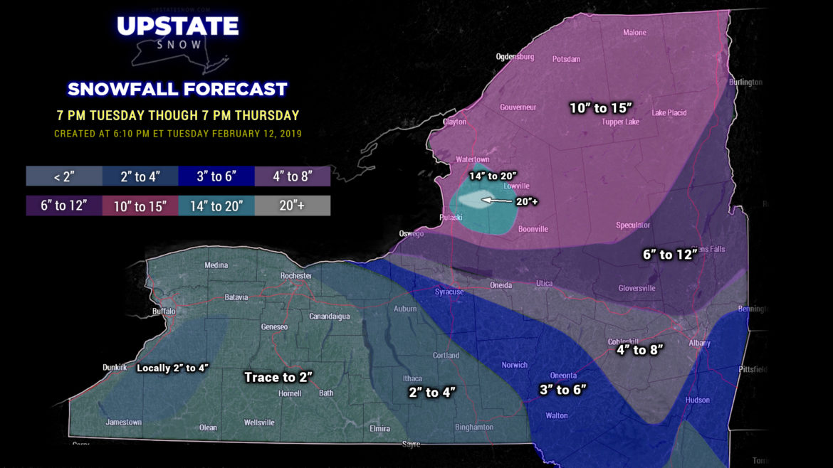
Much of the North Country should stay in the form of snow, but again, trending warmer with the system it wouldn’t be surprise if a snow/sleet mixture… or even a transition to sleet… occurs for places like Tupper Lake, Saranac Lake, Lake Placid, to Elizabethtown. Still… the heaviest snow totals from the “synoptic event” will be over the North Country.
Everyone everywhere will see a changeover back to snow from west to east as colder air surges in. A deep area of low pressure will move from southern Michigan this evening… to a position somewhere over Lake Superior early Wednesday morning. At the same time, another low will move from Maryland NNE to over NYC and then NE toward Boston by early Wednesday morning (this is a bit farther inland than originally expected). As the coastal system heads toward Cape Cod early Wednesday our winds will turn and pick up from the west / northwest. COLD air surges into the area, and any leftover mixed precip changes to snow. Our “original” low (the one to our west) will very slowly meander northeastward to the Ontario/Quebec border by Wednesday evening, keeping a stiff west-northwest wind blowing over much of the state. Some additional snow accumulations are likely across the state Wednesday BEFORE the LES starts to push in.
LES off of Lake Ontario comes ALIVE Wednesday afternoon, continuing through Valentine’s Day. Initially the band will have a 7 o’clock to 1 o’clock orientation extending from northern Lake Erie and then up the St. Lawrence. As the afternoon progresses, that wind continues to shift more WSW to ENE, and then W to E off the Lake. By Wednesday night, though, the lake band will start to weaken… and by Thursday the moisture gets cut off completely.
A snow forecast map is a bit challenging to create, given the two “separate” snow-producing events. In an effort to keep things relatively simple, we’ve drawn a 48-hour map — this evening through 7 PM on Valentine’s Day. So this will include the remaining “synoptic snows” and the Lake Effect, which, by Thursday evening, should have come to an end.
There’s not much rest for the wicked as the next storm system takes aim on our area Thursday night into Friday with more mixed precipitation or rain (probably either light snow or light rain)… the GFS is a little more aggressive on this one, and with the history of storms this season it will bear some watching.
And as of right now, the coming weekend should be dry with temps running just a touch above normal.
Be safe if you have to travel tonight and early Wednesday… and thanks for viewing and your support!


