Good evening everyone…
Game on.
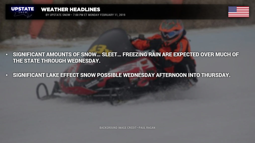
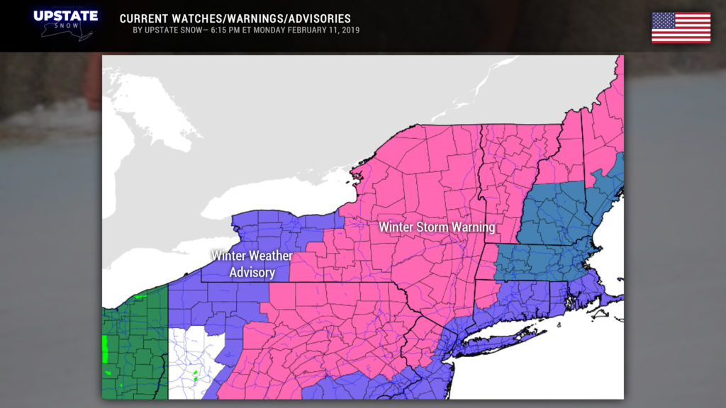
Snow… sleet… freezing rain… probably some “plain” rain as well… will target the Empire State beginning early Tuesday and last through Wednesday. Winter Storm Warnings are posted for much of the state, with Winter Weather Advisories up for western NY.
Gonna be real honest with you folks… this is one of the toughest storms to forecast. As mentioned last night, it’s at a point where 1 to 2 degrees can mean the difference between all of the above-mentioned precip types. Elevation will also play a role in this.
A very complex storm system will be centered over the Illinois/Indiana state line by time you sit down to breakfast on Tuesday, while strong high pressure will reside to our north. A southeast to southerly wind flow will become established over the state while moisture blasts northward. By Tuesday afternoon, two areas of low pressure will be centered over northern Ohio, while a third low takes shape off the Delmarva coast. By the evening hours, a very strong low will be centered over southern Michigan while our coastal system stays pretty much over the Delmarva, perhaps jogging slightly inland. A strong south to southeast flow will be pummeling the state throughout the day on Tuesday with copious moisture streaming northward. By early Wednesday our “initial low” lifts north into southern Ontario, while our coastal storm moves to a position over southern New England. By this time winds will be turning and colder air will be rapidly pulling back into the system. By Wednesday evening, our primary low should be located just north of the St. Lawrence, near the Ontario/Quebec border. A cold northwesterly wind flow will be established, which will last into Thursday.
“Dude …what does that mean?” The devil is indeed in the details. One of the devils early in this scenario is really dry air at the 10,000 foot level across CNY early Tuesday morning. The “column” (think of a “piece” of the atmosphere, from the ground to the stratosphere, put into a 3-dimensional cube)… the column will be quite moist from about 14,000 feet on up… but there will be a 6,000-foot layer that is desert dry… from roughly 8,000 feet to 14,000 feet… with still fairly dry air below that to the surface. The dry layer is REALLY substantial over the north country, we’re talking about a layer near 15,000 feet thick of desert-like dewpoint depressions.
As moisture lifts northward, it’s going to hit this like a brick wall. The moisture will stream northward and northward and will slowly saturate the column. I mean slowly. As well, this Sahara Desert layer sits at the bottom of the dendritic growth zone (the layer of atmosphere most conducive for the development of falling snow). With this dry air in place, no matter what our models say, no matter what the radar may look like, it’s simply not going to snow.
Devil #2: “Warmer” air pressing northward. Warm air rises up and over cold air, always, every time. That’s physics. Nearly all of our weather systems this season have ended up trending warmer than modeled. Why would this one be any different? We’re going out on a limb here and leaning on the “warm” end of the modeling. Other media outlets may disagree; that’s their prerogative. Anyway, while that moisture pushes north, warmer air will also be pushing north. This isn’t going to be an instant flip, the denser, cold air will hang tough as long as it possibly can, and I believe will do so at the surface for much… if not all… of this event. BUT… remember what I said about 1 or 2 degrees. The higher peaks of the Catskills, and especially the Adirondacks, may “poke” into the warmer layers as well… it’s possible that higher peaks go over to rain while the deeper valleys stay frozen (sleet or freezing rain).
SIDEBAR — How a “warm nose” works: When you have air that is below 32 degrees from the cloud base to the ground, you’ll have snow. But as warmer air lifts in, you get a layer (or multiple layers) “aloft” that rise above that 32-degree mark. Therefore, snowflakes fall into that warmer layer, and melt into water droplets, and then fall back into the colder layer. Ok, great. Well if the cold layer is sufficiently thick, the water droplets will re-freeze while falling and colliding with one another… this gives us sleet. However, as our warm layer gets thicker and thicker, and the slice of colder air becomes thinner and closer to the ground, these water droplets will not re-freeze. They will stay liquid to the surface — even into a layer that is, say, 28-31 degrees. The droplets are supercooled and freeze instantly to whatever surface they hit. That is freezing rain. –END SIDEBAR
Devil #3: Modeling differences. I mentioned earlier that our storms this season have trended warmer than modeling wants to suggest, so that’s what we’re expecting here. The “Icon” (which is a variant of the Euro) is crazy warm; transitioning nearly the entire state to a soaking rain during the overnight hours Tuesday night/Wednesday. I just don’t really buy into that, not even with double coupons. The GFS and Canadian are next in line… showing snow Tuesday… transitioning to mixed precip for several hours Tuesday afternoon/evening, and then a transition to all rain during the overnight hours Tuesday night… and then BACK to snow by daybreak Wednesday…. with gusty winds and snow showers continuing through the day Wednesday. The FV3-GFS trends a bit colder… still transitioning to all rain for WNY but keeping frozen precip of some type through the event elsewhere. The European operational agrees with the FV3-GFS.
“Gut instinct” says to expect something between the GFS/Canadian and the FV3/Euro solutions. Tuesday starts off with snow… once it finally saturates that dry layer. So as we get up Tuesday morning, it should be snowing (?? maybe) south and west of a line from roughly Rochester through Binghamton. Perhaps. Depending on how tough that dry layer wants to hold on. At any rate, this all pushes northeastward. By noontime, it should be snowing … probably fairly heavily, for much of CNY from the southeast shores of Lake Ontario through the Valley to the Capital District. A transition to sleet and freezing rain should be occuring as you go farther south and west. As the surface low continues into Michigan, widespread mixed precipitation (sleet and freezing rain) should be impacting much of the state east of I-81, and probably a transition to all-rain for the Fingerlakes west toward Buffalo and Jamestown. Moderate to heavy snow should be falling in the Adirondacks. Again though, that warm layer… we believe it’s going to push farther north, so it’s expected that a transition begins south of a line from Watertown to Port Henry later Tuesday afternoon.
Generally frozen precipitation continues for all of CNY, ENY, and the North Country into Tuesday night. This is where my confidence is lowest; it very well may be warm enough that most areas south of the Thruway transition to rain for at least a couple of hours. Eventually the surface low off the coast lifts over Long Island into Connecticut and Rhode Island, toward Cape Cod, while the initial low lifts into southern Ontario. Winds will shift and cold air wraps in pretty quickly… by Wednesday morning any leftover mixed precipitation should be transitioning back to snow.
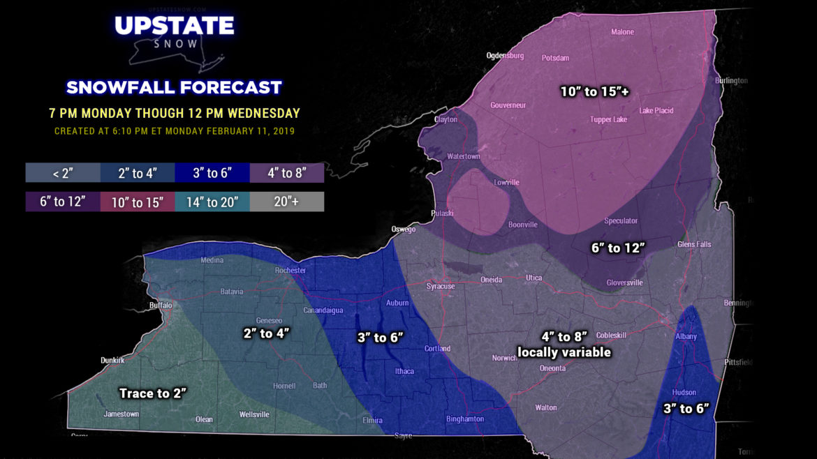
Our snowfall (and ice accretion) maps will go from 7 PM tonight through NOON on Wednesday. I want to differentiate the accumulations from our storm…. from the potentially very heavy lake effect coming in the aftermath of the storm.
Full disclosure: Confidence is… not great.

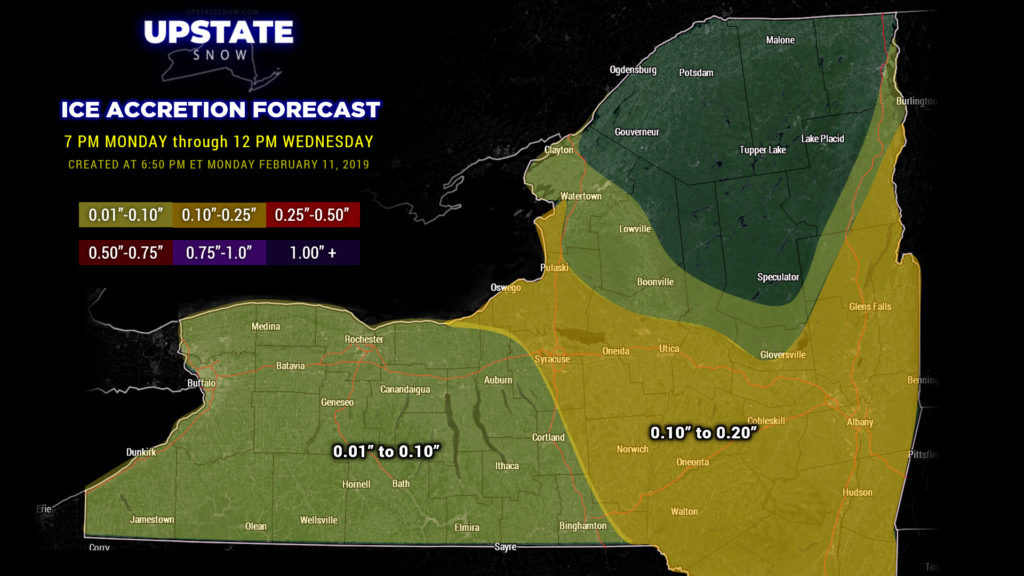
As we go into Wednesday afternoon, the focus changes from “synoptic snows” (from our storm system) to lake effect snows, especially east of Lake Ontario….. along with gusty winds.
From a winds standpoint, a very tight pressure gradient will set up between our departing storm system and high pressure trying to build in. The atmosphere desperately wants to be in a state called “geostrophic balance,” and one way to put itself that way is to create strong winds. We’re probably going to be looking at winds 35 to 55 mph for much of the state west of I-81, especially closer to Lake Erie.
Lake effect snow: The typical WNW-to-ESE wind flow will result in the typical targets getting hit … possibly pretty significantly … with LES. Lake Erie has a decent amount of ice, but there’s enough open water that the Chautauqua Ridge gets “shovelable” snow… but the Tug… a very early guesstimate … I think we’d be safe in saying at least a foot of new snow from Lake Ontario Wednesday into Thursday.
THE NEXT SYSTEM—-This coming weekend. Absolutely zero… zilch… nada… no model agreement … at … all. So you know what? We’re going to forget about that for right now.
Tomorrow is going to be a real mess for travel concerns. Please keep this in mind if you have anywhere you need to go. Allow a lot of extra travel time and pack your patience. Be safe…

