The #SecondChanceWinter just keeps rolling right along!
Good evening! Windy with areas of moderate to heavy snow continue from Ogdensburg south through Watertown, Oswego, Syracuse, Oneida, Utica, Elmira, Ithaca, Binghamton, Norwich, and Oneonta as of this writing. This will continue through the evening and overnight hours, GRADUALLY diminishing in coverage and intensity overnight. In the meantime, additional significant snowfall can be expected through the night tonight.
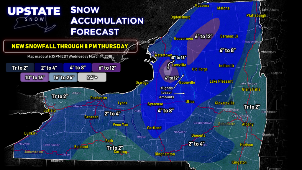
Our snow map — which illustrates NEW snowfall from 8 PM Wednesday through 8 PM Thursday — continues to bullseye the Tug Hill for an additional foot or more of snow over the next 24 hours, with a wider area of 6″-12″ totals. Uplift enhancement brings an additional 6″ to 12″ over the northern Adirondacks as well. A large area of 4″ to 8″ snow totals are expected over central and northern New York, but there will probably be lesser amounts along the Black River / route 12 from Lowville proper down to Boonville and into east-central Oneida County. It’s tough to call, but the high-res modeling shows lighter amounts in this area and we kind of leaned in that direction.
As mentioned last night, the same applies tonight in the 4″ to 8″ area. Not “everyone” will see these numbers… this represents an average over the entire region, rather than trying to figure out exactly where the lake bands set up. Hey… it’s the middle of March. We’ll take whatever we get.
Elsewhere, 2″ to 4″ can be expected for the Susquehanna region into the Catskills and the northern Fingerlakes region, as well as western New York east of Lake Erie (2″ to 4″ might be a bit of a stretch there after looking at radar trends).
Now one thing we will say — and repeat — it IS the middle of March. It’s hard to get snow to “stick” during the daylight hours. Even with colder-than-normal temperatures, a higher sun angle helps warm the ground juuuust enough that melting occurs. There’s also a good bit of “compacting” to the snow. The nature of the beast in March. That’s why some areas might not have picked up as much as others today. That needs to be considered when thinking about snow amounts.
This snow isn’t really going anywhere, even with it being mid-March and with a higher sun angle. Unseasonably cold, northwest winds will continue the rest of Thursday into Friday, followed by a reinforcing shot this weekend. With lows in the teens… and even SINGLE DIGITS… this will allow our groomers to do their thing and it will be a very good weekend for riding. Just be sure to call ahead FIRST.
NEXT WEEK—
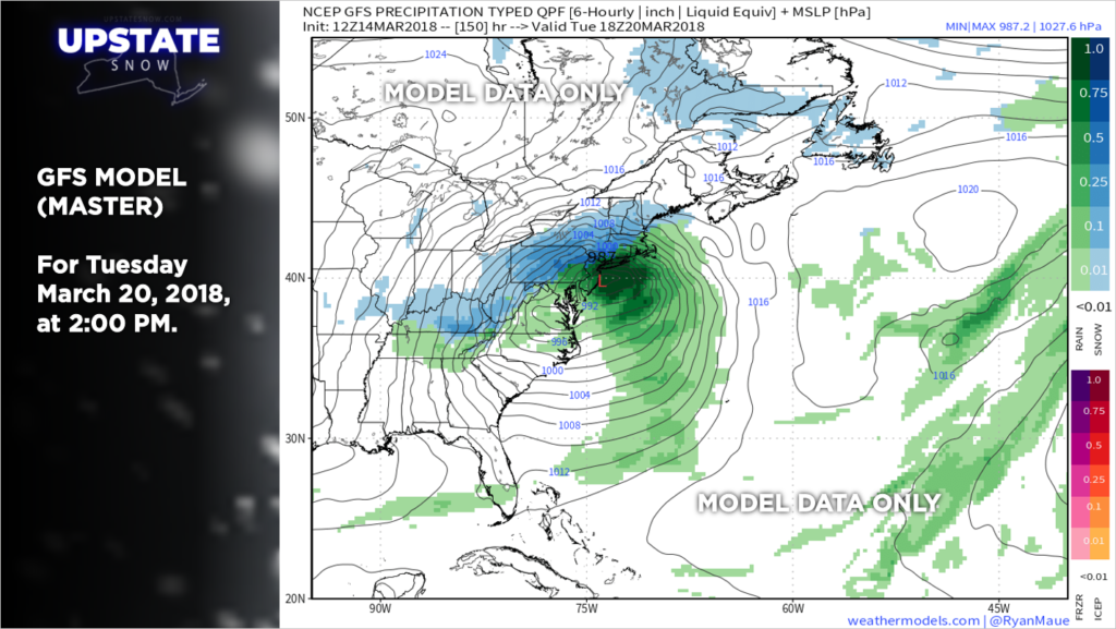
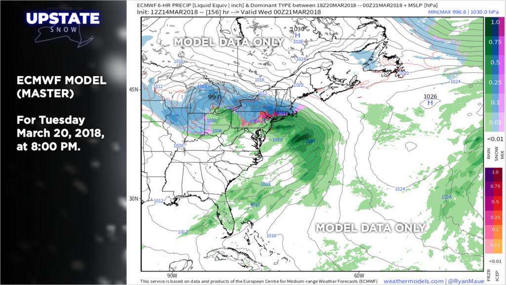
What? You want MORE snow? Well… take a look at this.
Low pressure over the southern plains would move to the Ohio valley and weaken, as energy transfers to a new low that would explosively strengthen off the Jersey coast.
Now… we’re 5-6 days out so don’t get TOO caught up in this. The models will likely go back and forth and change their opinion more often than a politician confronted with Professor Snape’s Veritaserum. The NAO block will have a lot to do with the eventual outcome of this POTENTIAL storm. If the block is strong, the storm would track a bit more to our south… in fact, it could track far enough south that we don’t get much snow out of it at all. OR… if the block is weak, we could have a more northerly track to the system, especially the “western prong” (the Ohio low), which would result in a messy wintry mix or even rain. There’s lots of time to watch this.
In the meantime, ENJOY the weekend riding!
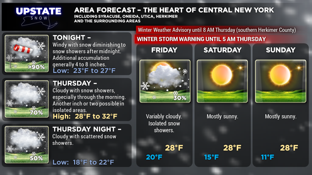
Here are your zone graphics.


