Good evening, and welcome to the NEW Upstate Snow! We’re very excited about our new website and hope you’ll take the time to explore all the features! Also… you can now click / tap on the graphics in our nightly posts to enlarge them.
“Why is forecasting so difficult? Consider a rotating spherical envelope of a mixture of gases, occasionally murky and always somewhat viscous. Place it around an astronomical object nearly 8,000 miles in diameter. Tilt the whole system back and forth with respect to its source of heat and light. Freeze it at the poles of its axis of rotation, and intensely heat it in the middle. Cover most of the surface of the sphere with a liquid that continually feeds moisture into the atmosphere. Subject the whole to tidal forces induced by the sun and a captive satellite. Then try to predict the conditions of one small portion of that atmosphere for a period of one to several days in advance.” Author unknown.
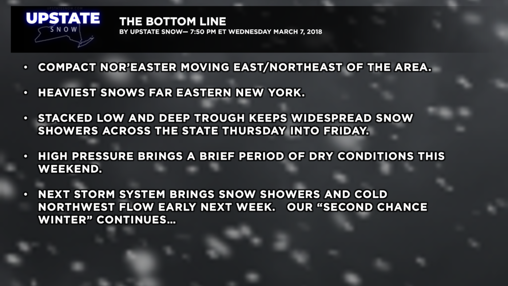
Everything was in place exactly as it was supposed to be… the 500-mb low over the Great Lakes, a beautifully negatively tilted trough over the region, and our nor’easter churning its way northeastward along the coast. Except our nor’easter is a lot more “compact” than was initially expected, and there has been a slight jog eastward in the actual storm path. Remember we posted the other night that any shift in storm track could mean major changes in what actually falls — this was the perfect example of that.
Looking at storm totals, Sullivan county did quite well with 12.3 inches at Woodridge as of 6:30 PM, Glen Spey coming in at 12 inches, and Swan Lake with 11 inches. Our friends in eastern New York also did well, with Taghkanic, in Columbia County, checking in with 14.4 inches as of 5:02 PM; Austerlitz with 11 inches, as well as Chatham. Over in Rensselaer County, Berlin is reporting 9 inches as of 6 PM. Knox, in Albany County, reports in with 9.5 inches as of 5:01 PM, Guilderland with 7 inches. Schoharie, which picked up nearly 40 inches in the last storm, adds 6.2 inches to the ground as of 5:17 PM, and Wallkill, down in Ulster County, reports 14 inches as of 6:02 PM. So there were some areas that picked up a decent amount of new snow.
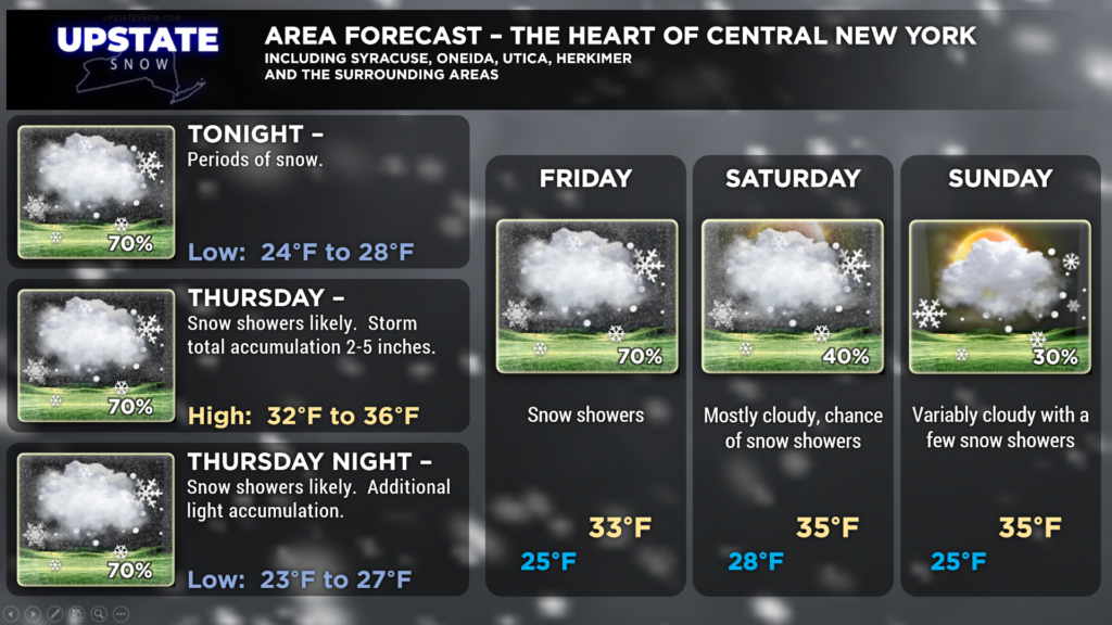
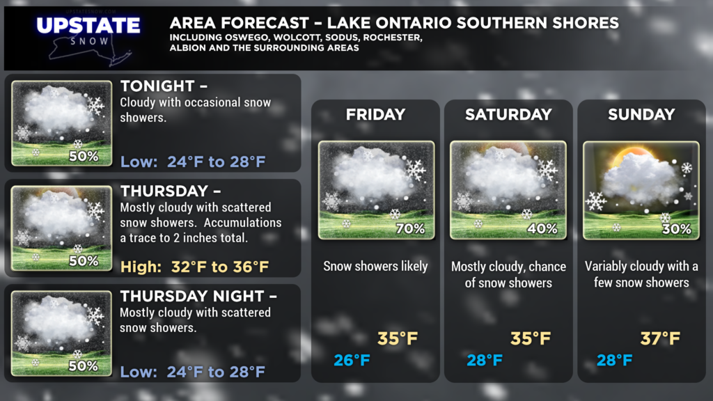
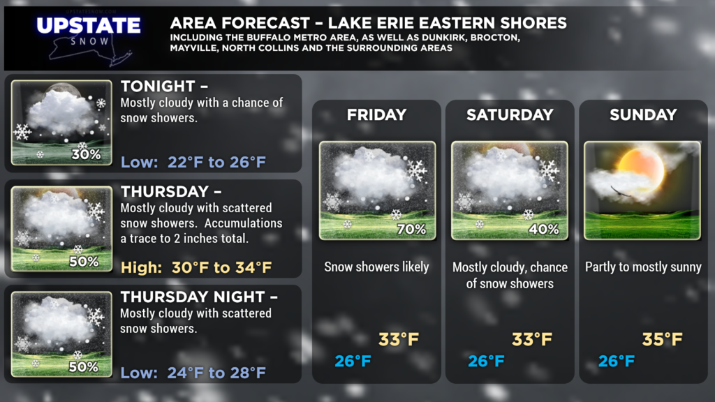
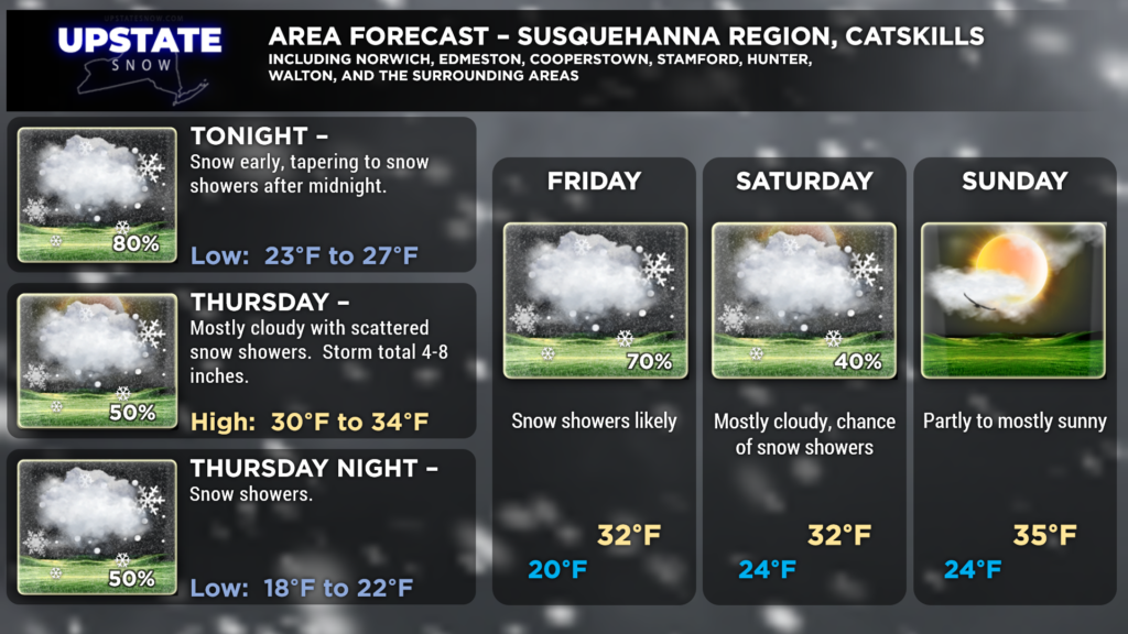
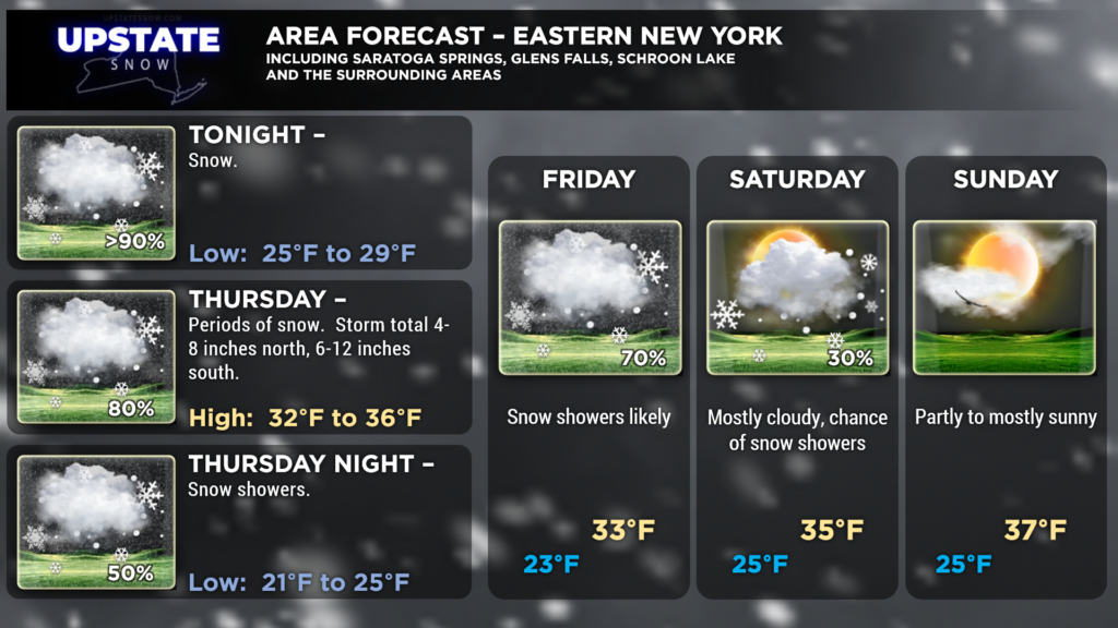
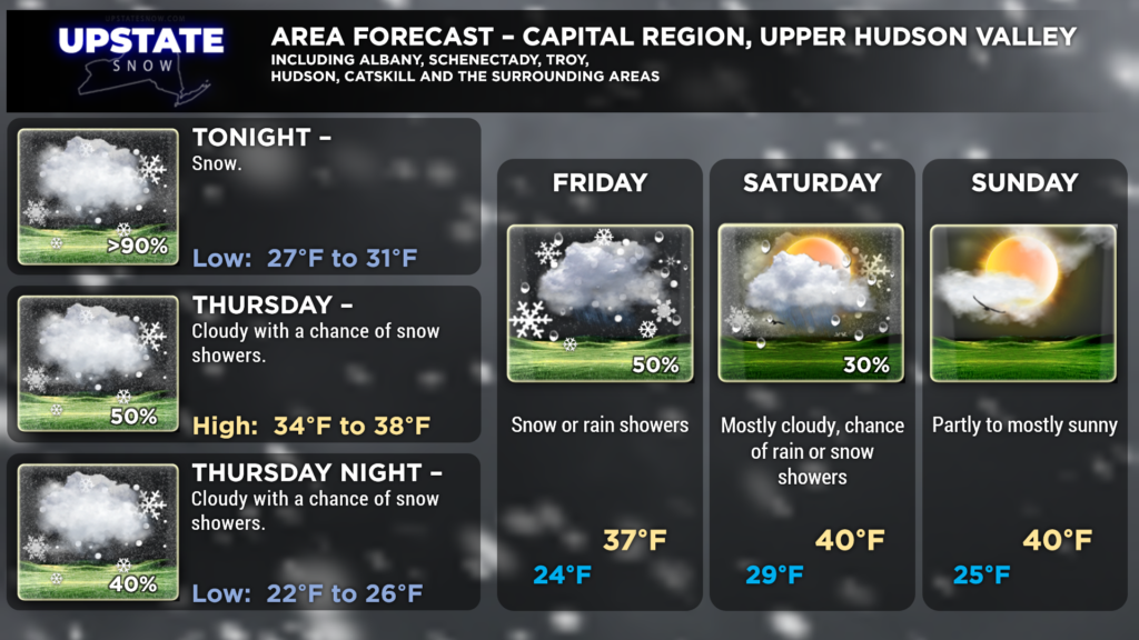
Our storm will continue to wind up like a top and northeastward, then northward into southern Maine… before retrograding a bit west as we get into early Friday. Meanwhile, a “stacked” area of low pressure — at the surface and upward through about 18,000 feet, will tend to drift aimlessly over the Great Lakes and northern New York through early Friday. This will keep periods of snow in the forecast through the day Thursday, as well as into Thursday Night and Friday.
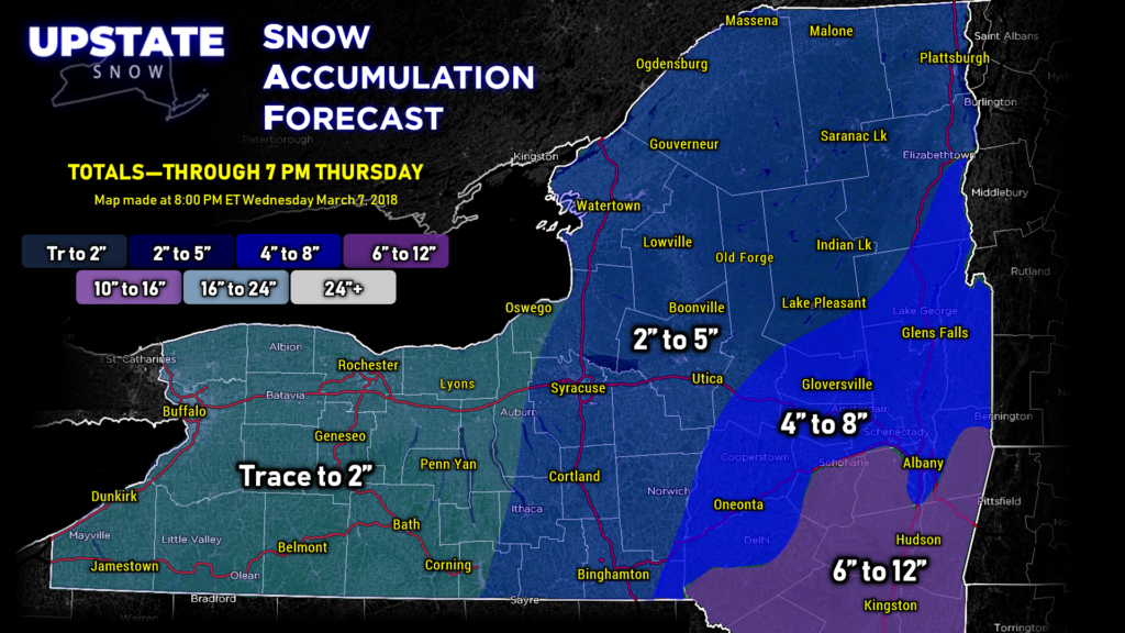
It was a real challenge to put together this evening’s snow map, as we still have snow from the nor’easter affecting eastern New York, but we wanted to account for that which is expected to fall through the day Thursday as well. So splitting the difference our map tonight says “totals” through 7 PM Thursday… this will include a lot of what has already fallen from the nor’easter, plus the additional generally light accumulations for Thursday.
High pressure will slowly start to take control of our weather as we get into the weekend, with a slow drying trend and seasonable temperatures.
Unsettled weather will work back into the state on Monday. Another upper low (actually really it’s the same one that will get “closed off” — meaning the steering wind currents will be “around” the low causing it to get kind of locked in place); anyway this low, with its attendant trough, will keep scattered to numerous snow showers over the state next Monday and Tuesday, along with a colder-than-normal northwesterly flow.
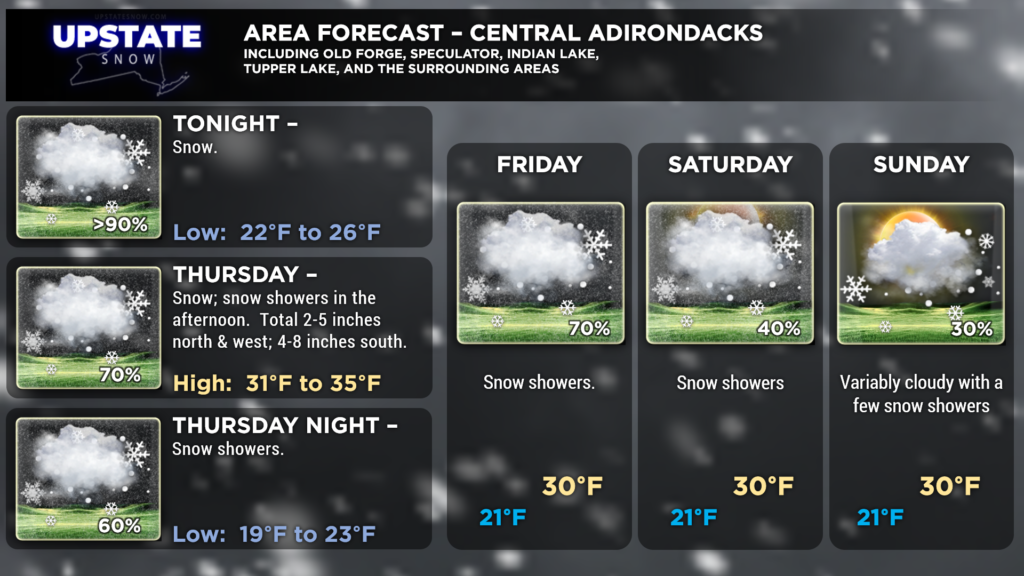
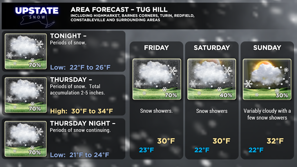
That’s it for tonight, here are your zone area forecast graphics. Take care and thanks for viewing!


