11 PM Update Saturday 11/30 (Basically almost December 1)
All storms have their challenges. Especially the first “big one” of the year. Even more so when it hits on a holiday weekend for travel. Even more so when you have mixed precip (sleet/frz rain) to deal with. Even more so when the rare “stall” happens to a storm developing on the coast.
Guess what? We’ve got it all in one shot! So ready or not, here we come.
Our storm is right on schedule. Cold air certainly in place across Upstate awaiting the moisture to arrive in WNY and Southern Tier Sunday morning, CNY and Catskills towards Midday and early Afternoon, Capital Region and Adirondacks Sunday afternoon. When this wave of moisture (or part 1) of this storm arrives, it will go from nothing to bang, 1/2 inch to 1 inch per hour snows, low visibility and sleet mixing in (south of the Thruway) and freezing rain (west of Rochester, especially Buffalo area and Southtowns). It will get bad quick. If you have to travel, try to do it ASAP or wait until Sunday night after the first wave rolls through the state. Given the heavy traffic, this is the big concern and message to get out. Will travel be impossible? No. Will it be the worst you’ve ever seen? No. But add a ton of people on the highways rushing to and fro and a solid winter storm, you have a recipe for accidents, backups, and travel headaches. Be prepared, take it easy. Figure at least double the normal time if traveling in daylight on Sunday 12/1. Here is the weather map projected for 1 PM Sunday 12/1
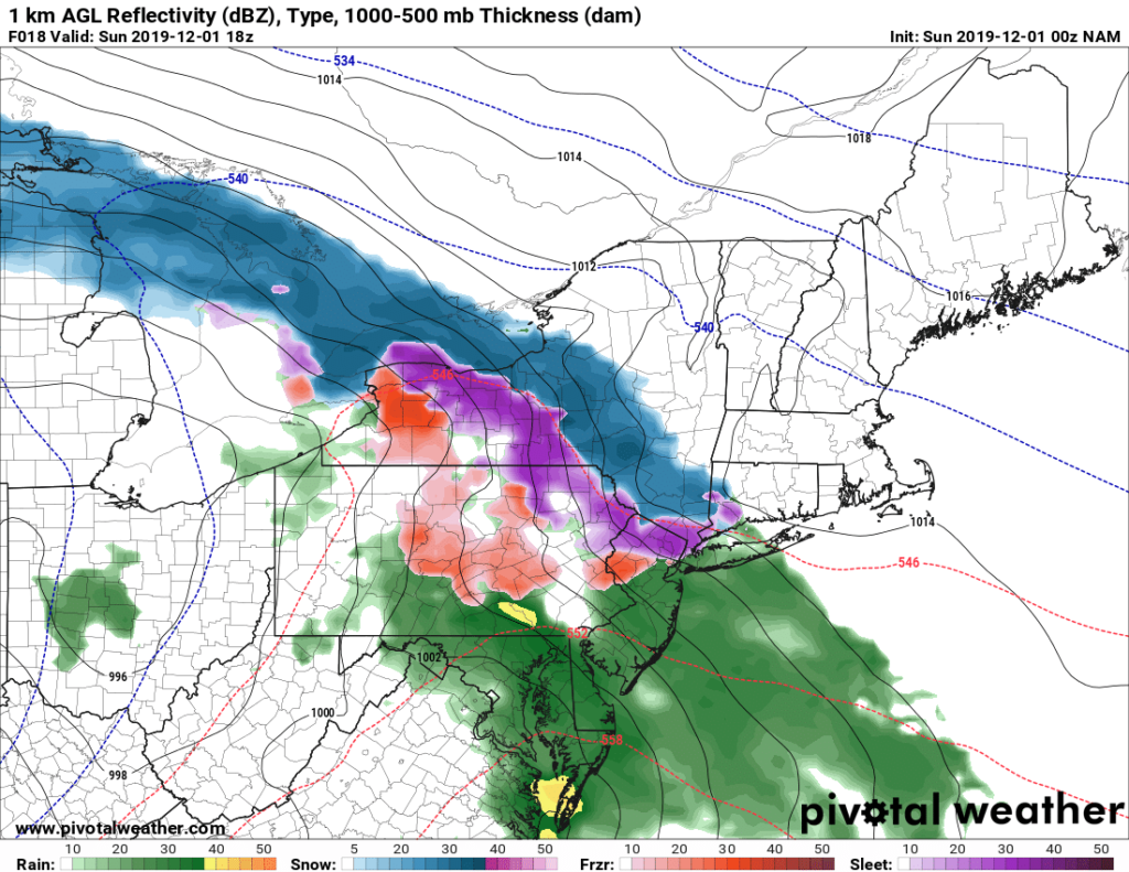
The new coastal low starts to take shape by 7 PM Sunday 12/1 off the coast of NJ by Atlantic City. Notice sleet still an issue mainly S of the Thruway which may make travel icier and may also limit snowfall amounts on the front end (part 1) of the storm. If this happens it may not necessarily mean the snowfall and big snow totals don’t happen. Remember this accumulation storm forecast is 48 hours, TWO FULL DAYS.
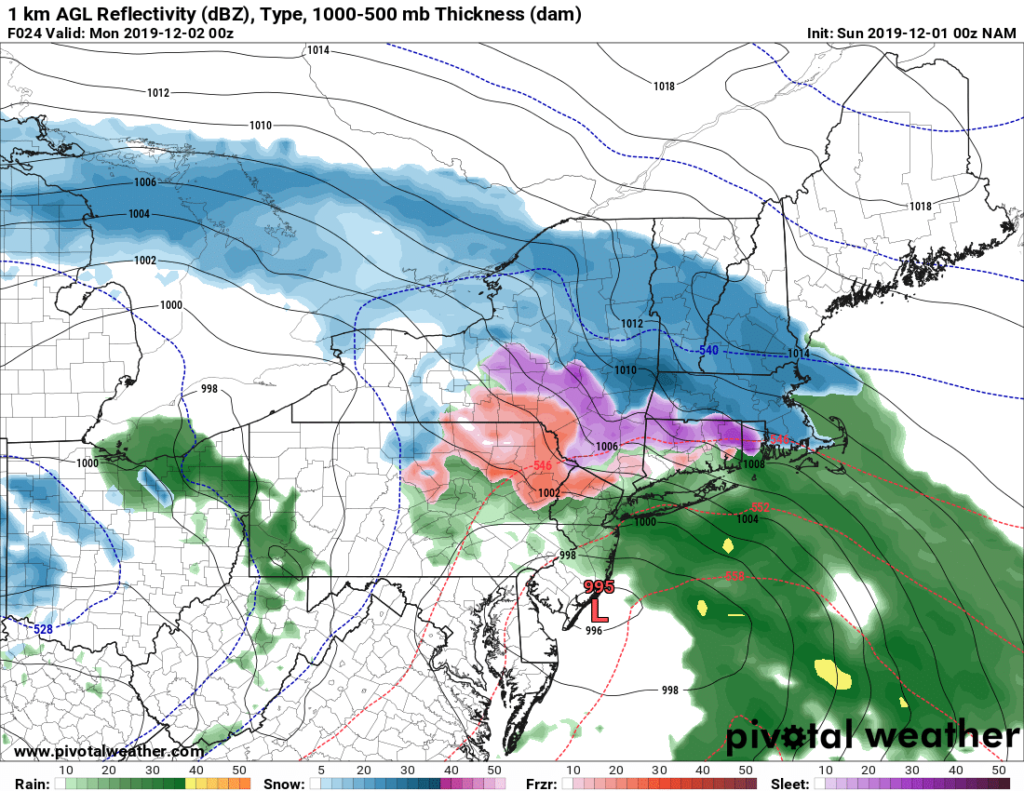
The best chance for there to be a break in the precipitation, especially snow, would be between 7 PM Sunday 12/1 and 7 AM Monday 12/2. It is not uncommon to have a break in the precip as the “primary low”, the big storm over the Plains and western Great Lakes, transfers its energy to the Atlantic coast to develop the “secondary low” or the coastal low. Again I cannot emphasize enough, if you wake up and you are in an area with a Winter Storm Warning with double digit potential snowfall totals, and you only have a few inches of snow and sleet as you wake up before dawn early Monday 12/2… IT IS NOT OVER! By daylight on 12/2, the storm center goes right off NY Harbor, in a perfect position to DRILL CNY, the Capital Region, Catskills, southern half of the Adirondacks and the Binghamton area with steady moderate to heavy snow. AND THE STORM STALLS FOR SEVERAL HOURS DURING THE DAY MONDAY
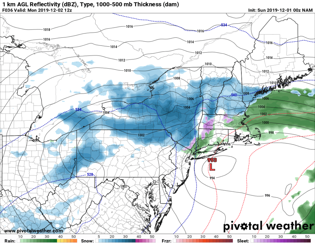
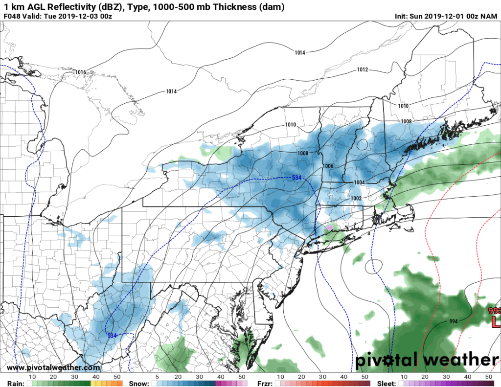
Notice by 7 PM Monday night, the storm center (Closed circle S or Rhode Island.. don’t pay attention to the L on the far bottom right), FINALLY starts to lift out, but notice as darkness falls on Upstate NY Monday night 12/2, most of the Central and Eastern part of the state is still getting hit with steady snows. It will take all night for it to wind down and should be over by Tuesday morning 12/3 as the winds turn N and the low center heads for the Gulf of Maine.
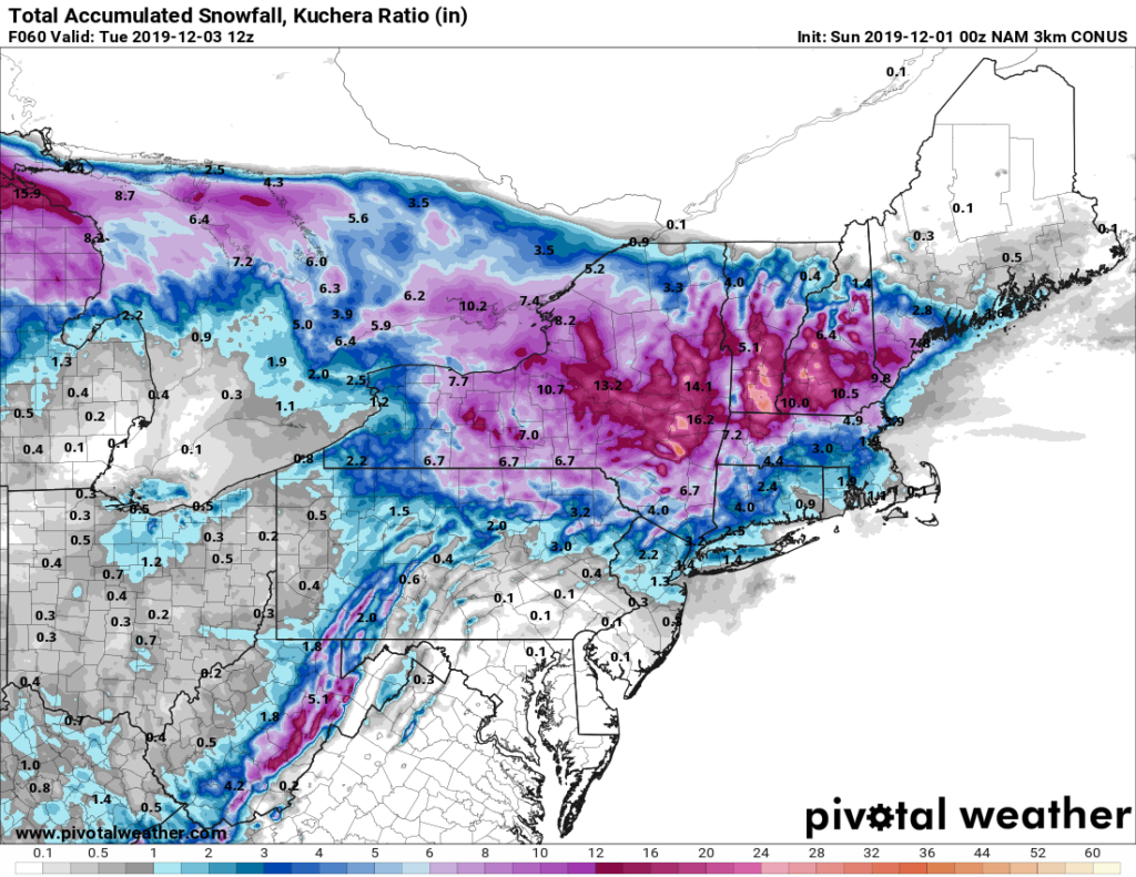
So what kind of snowfall are the models putting out? When you consider each model is handling the mixed precip differently, has different ideas on timing, how long it stalls and how far the snows spread south towards NYC, NJ and PA, also W towards the Finger Lakes and Rochester areas, it is NOT an easy forecast. I’ll show you for your own eyes the data I’ve had to review and use my experience to analyze…
The NAM
The NAM 3K (High Resolution)
The vaunted Euro model, high resolution

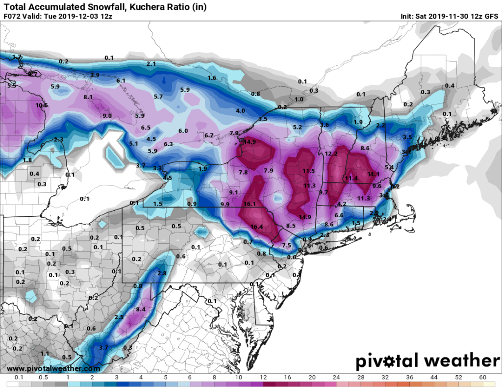
And last but not least, the American GFS which has suddenly some weird ideas on snowfall across Central NY, as well as almost shutting out completely anything getting W of NYS Highway 14 that bisects the Finger Lakes from Sodus and Geneva to Watkins Glen and Corning…
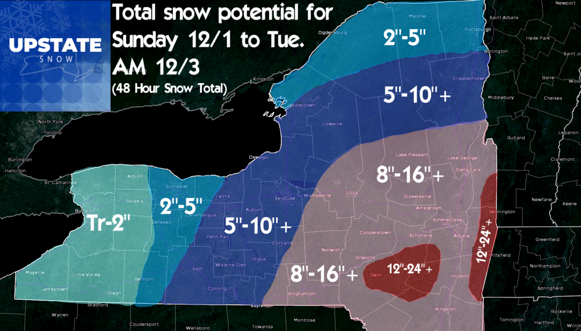
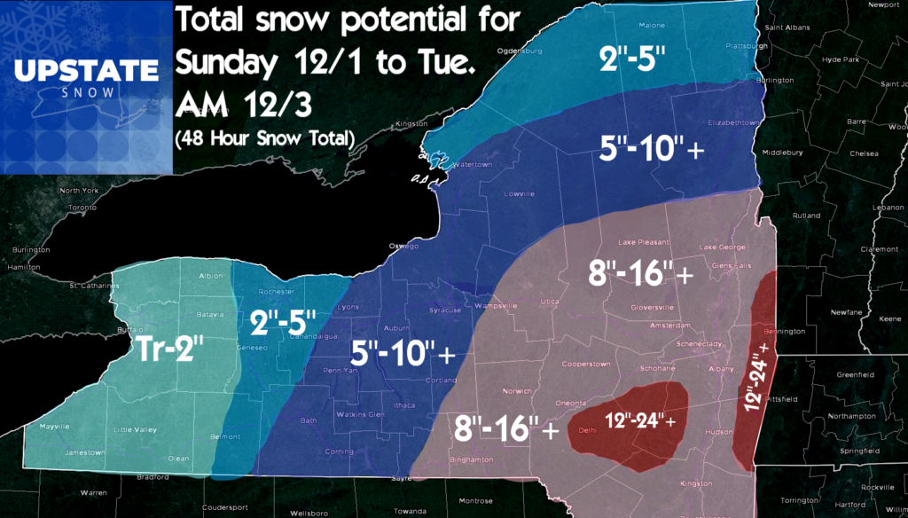
OK Mr Meteorologist, so what say you? After analysis of several model runs, here are my points and my “why’s” as to the snowfall map being the way that I made it…
- The position of the low pressure, along with the troughs at 850mb, 700mb and 500mb favor a line basically close to I-88 from Binghamton to Albany getting the heaviest snow. If that moves, so will the totals.
- The mountains will wring out more moisture. Historically in these storm situations the Catskills, Helderburgs (Escarpment just W of Albany), Taconics (Mt Range between the Hudson Valley and the Berkshires of Western Massachusetts/Green Mts of Southern Vermont) usually end up beating out the Hudson Valley and immediate Capital Region by several inches. Plus climo of getting 18″+ in Albany in one storm puts you in a rare league. Therefore the bullseyes are basically the mountains surrounding Albany
- I did back up the heavier snows into the Southern Adirondacks, Mohawk Valley and the Syracuse areas. I would not surprise me to see the ranges in these areas exceeded, the +, with Tug Hill and the hills along Route 20 from Duanesburg to Lafayette being my prime suspects.
- I do think the Finger Lakes will get in on the action this time, even the Elmira/Corning area. Also, while the Southern Adirondacks will get the jackpot, Old Forge, Inlet, Moose River Plains, Perkins Clearing, Indian Lake and Warren/Essex Counties will do well out of this storm. Tri-Lakes to the north end of the Adirondacks up towards St Regis will be a little too far away based on track.
- Watch Wayne and Monroe Counties… Depending on the stall position and the upper level winds, I may not be factoring enough lake enhancement from Wolcott and Sodus to Webster and possibly the City of Rochester. That 5-10 could sneak that way…
- The broad ranges: I have to account for two things. The first is sleet. I’ve been burned too many time when sleet mixes into a snow event. Many forecasts out there are higher than mine. If it’s 100% snow, they’ll be right and i’ll be a touch too conservative. I am banking on sleet holding some numbers down. Second is where the storm stalls. If it wobbles 25-50 miles off track, big difference where the bands set up. Hence why the larger ranges I have citing less than full confidence in mixing and/or track positions.
- Beware the deformation zone. A deformation zone is a band of steady, heavy snow, with hardly any wind at the surface. This also occurs in the dendrite growth zone, where the biggest snowflakes form, between -10 C and -18 C if relative humidity in these layers is near 100%. This layer is between 700 mb and 500 mb and looks to be oriented along or just N of my bulls-eyes. It also could extend to I-81 and maybe a county west.
So with all of those things I thought about in making this map, here is the call. If we get into the event and any of the above factors becomes obvious and forces a change to the map, I’ll pass it along as soon as possible:
So what happens after this storm? COLD! At or below normal temperatures the rest of the week. Indications are for two clipper systems to hit us, one Wednesday night/Thursday AM, another one next weekend, probably Friday night into Saturday. The timings may change based on what this storm is going to ultimately do.
So what does this mean for snowmobile season? It means we have a decent shot at being able to ride Old Forge/Inlet, Hamilton County starting Monday December 9. Not before this and certainly not anywhere the storm will hit with max snowfall. Snowmobile season starts when hunting seasons end, which for most of the state is December 17th, conditions permitting. ALWAYS CHECK WITH CLUBS FIRST BEFORE YOU RIDE ANYWHERE, ESPECIALLY EARLY SEASON! We’ll pass along any information we can as we get closer to December 9 for riding up north.
Unfortunately a pattern change to milder (at or above normal temps) looks to hit second week of December, possibly lingering through the third week, the full week before Christmas. Jury is still out on this one, but confidence is HIGH that we won’t see any big snowstorms of this type until around or after Christmas. Our best hope for keeping this early bounty of snow will be clippers, some lake effect, and keeping things JUST cold enough. Time will tell. But if you are itching to ride, Opening week heading into Snowdeo is a good possibility as of right now.
If you want to see the latest video from 11 AM Saturday 11/30 https://www.facebook.com/UpstateSnow/videos/410802443133248/
We plan to be Facebook live Sunday 12/1 in the afternoon probably around 2-4 PM. Be on the lookout. We’ll update on the FB page and the site as needed through the event.
If you want to hear our new podcast series, the Trail Talk Podcast https://www.upstatesnow.com/podcast/
And if you want a great deal on Curve skis for your sled, you can buy them right here through us and get great extras including Upstate Snow Swag and a $50 Stewart’s Card
https://www.curveindustries.com/pages/upstate-snow-curve-industries-store
Don’t forget to like and follow the page if you haven’t already… give us a share on the posts/videos you like as well.
And thank you so much for your support of Upstate Snow.
Rich & Zack

