Good evening!
Well, we said last night this was a difficult forecast scenario with some bust potential, and that certainly happened in some areas this morning. It is what it is.
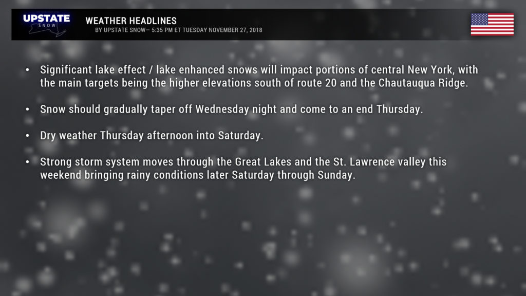
Ok. Our upper level low, or “closed low” we’ve been talking about for a few days will strengthen a bit and linger over northern Vermont through Wednesday. A deep, moist, cold northwest flow will continue through Wednesday… which will result in lake effect / lake-enhanced snow, as well as lingering “synoptic” snow (from the closed low). Temperatures at 5,000 feet earlier this morning were around 5 below zero Celsius, with temps at 10,000 feet roughly 15 below zero Celsius…. these air temps are flowing over water temps that are still “warm.” This creates lift, which creates instability, which creates heavy snows to the southeast of Lake Ontario (with a WNW wind flow) and east of Lake Erie (with a more westerly flow).
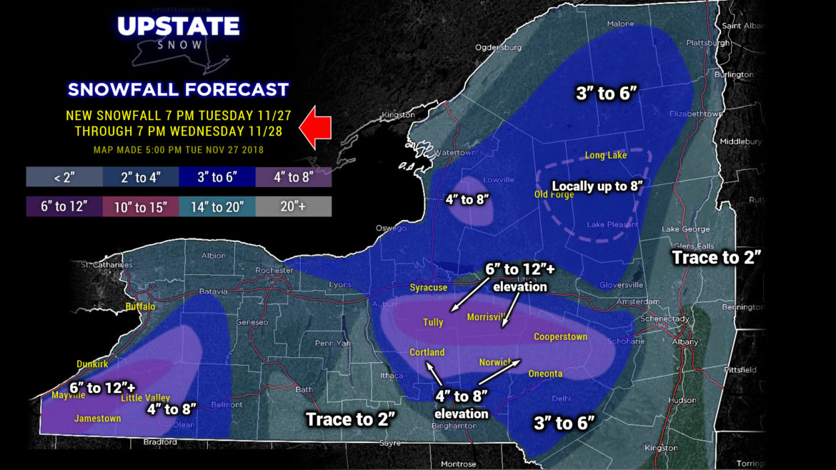
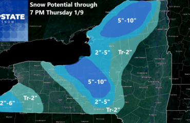
The snowfall will be greatly enhanced by upsloping… and snowfall amounts will be MUCH HIGHER in the higher elevations. High-resolution modeling goes crazy with over a foot in the higher elevations of Cayuga, Onondaga, Cortland, Madison, Chenango, Otsego, and even Delaware counties… while the lower elevations in the same areas get perhaps 3-6 inches of snow, if that. Our forecast is somewhat reflective of the high-res modeling, but we’re gonna pump the brakes a time or two — the highest accumulations (around a foot) will be in the highest elevations. Not everyone is going to see a foot of snow across those counties. And there may be a few isolated areas that end up measuring 15-16 inches of snow by suppertime tomorrow.
In looking at Lake Ontario a little further, surface winds are blowing west-northwest to east-southeast… from 9:30 on a clock face… but winds at roughly 10k feet are more northwest-to-southeast (perhaps 10:30 on the clock face). Therefore, if you’re looking for blockbuster snow totals on the Tug, well, it’s not going to happen. I’ve painted 4-8 for the tug, but it wouldn’t be surprising to see an isolated 10-12 inch total. I also put in a bracket for “local” higher amounts across Herkimer and Hamilton counties. The rest of the snows in the Adirondacks are, again, synoptic snows from the low aided and abetted by some lake enhancement and upsloping.
As for Lake Erie, here’s where we believe the big bullseye will be, especially late tonight through about noon on Wednesday. The winds at the surface are nearly west-to-east, maaaaybe a tad south-of-west… think 8:45 on a clock face. Upsloping, again, will really tap into the abundant moisture and most of the Chautauqua Ridge will be the recipient of around a foot of new snow through Wednesday afternoon.
And, unfortunately, portions of the Fingerlakes just aren’t going to see a lot out of this.
Our snow map goes through 7 PM Wednesday. I can’t emphasize this enough, NOT EVERYONE will see the higher snow totals. These totals are ALL elevation-dependent. And, in all honesty, the bust potential is once again pretty high. This is a complicated forecast.
Late Wednesday night through Thursday should feature scattered show showers about most of the Upstate as our closed low departs. High pressure should start to ridge in later Thursday, drying things out.
No major changes in the weekend outlook. A fairly energetic cyclone will form over the midsection of the country and take aim on the Great Lakes. A deep flow of moist air originating in the Gulf of Mexico will pump our temperatures above normal… we could even see some highs in the 50s for portions of the state by Sunday. At the same time, expect rain to develop (or rain/snow mix) late Saturday night and continue through Sunday. A cold front then sweeps across the state sometime Monday.
Have a good evening, thanks for viewing our page, and be safe.

